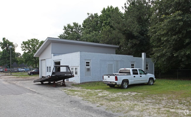
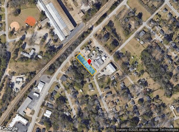
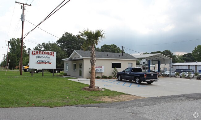
Property Record
1705 Frink St, Cayce, SC 29033
NEARBY LISTINGS FOR SALE OR LEASE
Property Detail
1705 Frink St
Commercialnec
Lexington
X
South Carolina
45063C0279J
0.37 AC
2025
Cayce/West Columbia
2024
Columbia
020100
Columbia, SC
2,908 SF
005724-08-005
DEMOGRAPHICS near 1705 Frink St
1 Mile
3 Mile
5 Mile
2024 Total Population
6,303
42,161
110,021
2029 Population
6,857
45,554
116,494
Pop Growth 2024-2029
+ 8.79%
+ 8.05%
+ 5.88%
Average Age
41
37
36
2024 Total Households
2,764
17,923
48,277
HH Growth 2024-2029
+ 8.94%
+ 8.82%
+ 6.15%
Median Household Inc
$55,000
$44,945
$48,315
Avg Household Size
2.20
2.10
2.00
2024 Avg HH Vehicles
2.00
2.00
2.00
Median Home Value
$126,365
$145,884
$172,688
Median Year Built
1967
1971
1975
Nearby Places
Map Layers
Map Styles
 Street
 Aerial
- Restaurants
- Banks
- Shops
- Fitness
- Groceries
PUBLIC TRANSPORTATION
COMMUTER RAIL
DRIVE
WALK
Distance
9 min
4.5 mi
AIRPORT
Columbia Metro
DRIVE
WALK
Distance
Columbia Metro
17 min
5.8 mi
Nearby Properties
Address
Land Use
TOTAL SIZE
Lot Size
Zoning
Address
Land Use
TOTAL SIZE
Lot Size
Zoning
440,418 SF
7.23 AC
M-1
Address
Land Use
TOTAL SIZE
Lot Size
Zoning
375,417 SF
3.92 AC
INS-GEN
Address
Land Use
TOTAL SIZE
Lot Size
Zoning
30,100 SF
3.45 AC
M-2
Address
Land Use
TOTAL SIZE
Lot Size
Zoning
311,168 SF
3.98 AC
MC
Address
Land Use
TOTAL SIZE
Lot Size
Zoning
490,633 SF
13.20 AC
RM-2
Address
Land Use
TOTAL SIZE
Lot Size
Zoning
352,672 SF
5.16 AC
MC
Address
Land Use
TOTAL SIZE
Lot Size
Zoning
254,900 SF
14 AC
M-1
Address
Land Use
TOTAL SIZE
Lot Size
Zoning
155,883 SF
2.74 AC
MC
Address
Land Use
TOTAL SIZE
Lot Size
Zoning
22,802 SF
2.64 AC
MC
Address
Land Use
TOTAL SIZE
Lot Size
Zoning
4.85 AC
MC
Address
Land Use
TOTAL SIZE
Lot Size
Zoning
121,560 SF
8.46 AC
RM-2
Address
Land Use
TOTAL SIZE
Lot Size
Zoning
196,800 SF
5.83 AC
HI
Address
Land Use
TOTAL SIZE
Lot Size
Zoning
12.50 AC
PD
Address
Land Use
TOTAL SIZE
Lot Size
Zoning
99,720 SF
3.81 AC
MC
Address
Land Use
TOTAL SIZE
Lot Size
Zoning
103,476 SF
2.04 AC
MC
Address
Land Use
TOTAL SIZE
Lot Size
Zoning
158,976 SF
11.28 AC
RM-2
Address
Land Use
TOTAL SIZE
Lot Size
Zoning
152,064 SF
9.58 AC
RM-2
Address
Land Use
TOTAL SIZE
Lot Size
Zoning
686,209 SF
1.73 AC
RM-2
Address
Land Use
TOTAL SIZE
Lot Size
Zoning
0.81 AC
MC
Address
Land Use
TOTAL SIZE
Lot Size
Zoning
237 AC
HI
Address
Land Use
TOTAL SIZE
Lot Size
Zoning
0.46 AC
C-1
Address
Land Use
TOTAL SIZE
Lot Size
Zoning
72,240 SF
4.33 AC
M-2
Address
Land Use
TOTAL SIZE
Lot Size
Zoning
69,770 SF
3.79 AC
RM-HD
Address
Land Use
TOTAL SIZE
Lot Size
Zoning
56,245 SF
2.75 AC
RM-2
Address
Land Use
TOTAL SIZE
Lot Size
Zoning
55,640 SF
2.57 AC
MC
Address
Land Use
TOTAL SIZE
Lot Size
Zoning
3.79 AC
MC
Address
Land Use
TOTAL SIZE
Lot Size
Zoning
75,326 SF
4.89 AC
LI
Address
Land Use
TOTAL SIZE
Lot Size
Zoning
39,172 SF
2.30 AC
RG-2
Address
Land Use
TOTAL SIZE
Lot Size
Zoning
14.88 AC
PD
Address
Land Use
TOTAL SIZE
Lot Size
Zoning
4.45 AC
MC
The World's #1 Commercial Real Estate Marketplace
Connect with us
© 2026 CoStar Group
The information above has been obtained from sources believed reliable. While we do not doubt its accuracy we have not verified it and make no guarantee, warranty or representation about it. It is your responsibility to independently confirm its accuracy and completeness. Any projections, opinions, assumptions, or estimates used are for example only and do not represent the current or future performance of the property. The value of this transaction to you depends on tax and other factors which should be evaluated by your tax, financial, and legal advisors. You and your advisors should conduct a careful, independent investigation of the property to determine to your satisfaction the suitability of the property for your needs.