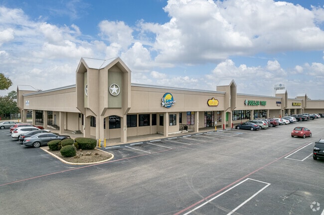
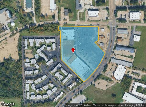
Property Record
1705 Garth Rd, Baytown, TX 77520

NEARBY LISTINGS FOR SALE OR LEASE
Property Detail
1705 Garth Rd
0451440030016
Abst 840 H Whiting
Regionalshoppingcenterormallwithanchorstore
TRS 2B 2B-1 5S 5U & 5V ABST 840 H WHITING
X
Harris
48201C0955M
Texas
2024
8.51 AC
2025
Channelview
254300
Houston
100,683 SF
Houston-The Woodlands-Sugar Land, TX
DEMOGRAPHICS near 1705 Garth Rd
1 Mile
3 Mile
5 Mile
2024 Total Population
11,300
67,160
95,627
2029 Population
11,609
69,109
98,742
Pop Growth 2024-2029
+ 2.73%
+ 2.90%
+ 3.26%
Average Age
34
36
36
2024 Total Households
3,952
23,859
33,386
HH Growth 2024-2029
+ 2.63%
+ 2.80%
+ 3.17%
Median Household Inc
$52,299
$51,776
$55,585
Avg Household Size
2.80
2.70
2.80
2024 Avg HH Vehicles
2.00
2.00
2.00
Median Home Value
$131,931
$151,138
$170,220
Median Year Built
1974
1978
1983
Nearby Places
Map Layers
Map Styles
 Street
 Aerial
- Restaurants
- Banks
- Shops
- Fitness
- Groceries
PUBLIC TRANSPORTATION
AIRPORT
William P Hobby
DRIVE
WALK
Distance
William P Hobby
43 min
28.1 mi
George Bush Intcntl/Houston
DRIVE
WALK
Distance
George Bush Intcntl/Houston
43 min
35.3 mi
Freight Ports
Port of Houston
DRIVE
WALK
Distance
Port of Houston
33 min
23.1 mi
SALE & LEASE HISTORY
LISTING DATE
SALE/LEASE

Sep 25, 2016
For Lease
Jul 15, 2022
For Sale
Nearby Properties
Address
Land Use
TOTAL SIZE
Lot Size
Zoning
Address
Land Use
TOTAL SIZE
Lot Size
Zoning
1,019.77 AC
Address
Land Use
TOTAL SIZE
Lot Size
Zoning
Address
Land Use
TOTAL SIZE
Lot Size
Zoning
815.98 AC
Address
Land Use
TOTAL SIZE
Lot Size
Zoning
857.55 AC
Address
Land Use
TOTAL SIZE
Lot Size
Zoning
1,019 AC
Address
Land Use
TOTAL SIZE
Lot Size
Zoning
Address
Land Use
TOTAL SIZE
Lot Size
Zoning
816.17 AC
Address
Land Use
TOTAL SIZE
Lot Size
Zoning
816.17 AC
Address
Land Use
TOTAL SIZE
Lot Size
Zoning
383,631 SF
22.45 AC
Address
Land Use
TOTAL SIZE
Lot Size
Zoning
874.07 AC
Address
Land Use
TOTAL SIZE
Lot Size
Zoning
323,413 SF
26.41 AC
Address
Land Use
TOTAL SIZE
Lot Size
Zoning
284,794 SF
10.18 AC
Address
Land Use
TOTAL SIZE
Lot Size
Zoning
209,703 SF
11.18 AC
Address
Land Use
TOTAL SIZE
Lot Size
Zoning
225,497 SF
10.90 AC
Address
Land Use
TOTAL SIZE
Lot Size
Zoning
313,810 SF
20 AC
Address
Land Use
TOTAL SIZE
Lot Size
Zoning
Address
Land Use
TOTAL SIZE
Lot Size
Zoning
238,488 SF
13 AC
Address
Land Use
TOTAL SIZE
Lot Size
Zoning
205,859 SF
10.88 AC
Address
Land Use
TOTAL SIZE
Lot Size
Zoning
214,627 SF
13.77 AC
Address
Land Use
TOTAL SIZE
Lot Size
Zoning
247,218 SF
12.44 AC
Address
Land Use
TOTAL SIZE
Lot Size
Zoning
816.17 AC
Address
Land Use
TOTAL SIZE
Lot Size
Zoning
313,504 SF
18.76 AC
Address
Land Use
TOTAL SIZE
Lot Size
Zoning
282,661 SF
14.68 AC
Address
Land Use
TOTAL SIZE
Lot Size
Zoning
100,274 SF
17.63 AC
Address
Land Use
TOTAL SIZE
Lot Size
Zoning
270,282 SF
15.19 AC
Address
Land Use
TOTAL SIZE
Lot Size
Zoning
7.79 AC
Address
Land Use
TOTAL SIZE
Lot Size
Zoning
221,571 SF
21.28 AC
Address
Land Use
TOTAL SIZE
Lot Size
Zoning
233,074 SF
19.10 AC
Address
Land Use
TOTAL SIZE
Lot Size
Zoning
203,740 SF
12 AC
Address
Land Use
TOTAL SIZE
Lot Size
Zoning
1,127,747 SF
59.72 AC
The World's #1 Commercial Real Estate Marketplace
Connect with us
© 2025 CoStar Group
The information above has been obtained from sources believed reliable. While we do not doubt its accuracy we have not verified it and make no guarantee, warranty or representation about it. It is your responsibility to independently confirm its accuracy and completeness. Any projections, opinions, assumptions, or estimates used are for example only and do not represent the current or future performance of the property. The value of this transaction to you depends on tax and other factors which should be evaluated by your tax, financial, and legal advisors. You and your advisors should conduct a careful, independent investigation of the property to determine to your satisfaction the suitability of the property for your needs.