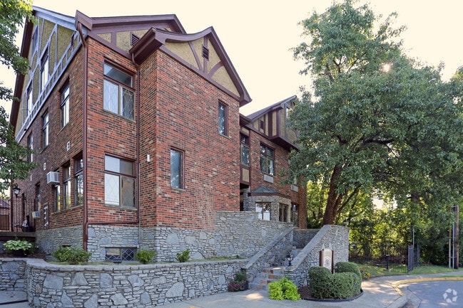
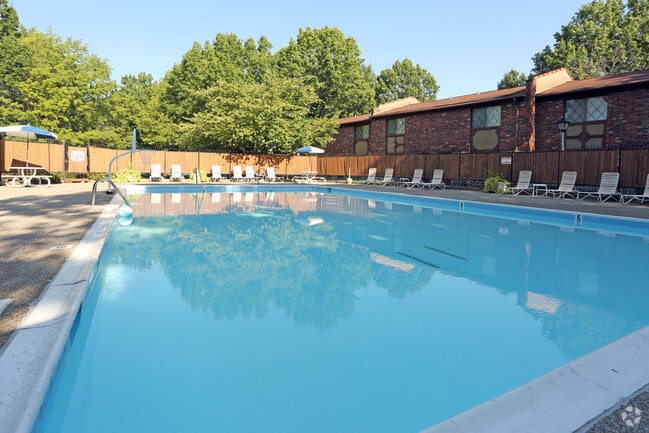
Property Record
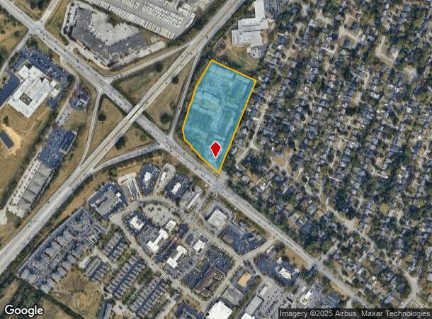
1705 Leestown Rd, Lexington, KY 40511
NEARBY LISTINGS FOR SALE OR LEASE
Property Detail
1705 Leestown Rd
24525800
Meadowthorpe Comm Bus Ctr
Clubslodgesprofessionalassociations
B-102C MEADOWTHORPE COMM BUS CTR LOT; BOOK: 3018 PAGE: 432
X
Fayette
2100670109E
Kentucky
2025
8.22 AC
2025
Meadowthrope
002200
Lexington/Fayette
7,024 SF
Lexington-Fayette, KY
DEMOGRAPHICS near 1705 Leestown Rd
1 Mile
3 Mile
5 Mile
2024 Total Population
4,964
83,914
163,951
2029 Population
4,976
84,692
164,600
Pop Growth 2024-2029
+ 0.24%
+ 0.93%
+ 0.40%
Average Age
39
35
38
2024 Total Households
2,278
34,648
68,223
HH Growth 2024-2029
+ 0.22%
+ 1.04%
+ 0.41%
Median Household Inc
$57,481
$47,006
$54,526
Avg Household Size
2.10
2.20
2.20
2024 Avg HH Vehicles
2.00
1.00
2.00
Median Home Value
$159,966
$205,731
$233,980
Median Year Built
1979
1983
1970
Nearby Places
Map Layers
Map Styles
 Street
 Aerial
- Restaurants
- Banks
- Shops
- Fitness
- Groceries
PUBLIC TRANSPORTATION
AIRPORT
Blue Grass
DRIVE
WALK
Distance
Blue Grass
14 min
7.3 mi
Nearby Properties
Address
Land Use
TOTAL SIZE
Lot Size
Zoning
Address
Land Use
TOTAL SIZE
Lot Size
Zoning
3,896 SF
0.49 AC
B-4
Address
Land Use
TOTAL SIZE
Lot Size
Zoning
14.90 AC
B-2B
Address
Land Use
TOTAL SIZE
Lot Size
Zoning
510,633 SF
15.10 AC
P-1
Address
Land Use
TOTAL SIZE
Lot Size
Zoning
82.77 AC
R-4
Address
Land Use
TOTAL SIZE
Lot Size
Zoning
Address
Land Use
TOTAL SIZE
Lot Size
Zoning
87 SF
R-4
Address
Land Use
TOTAL SIZE
Lot Size
Zoning
Address
Land Use
TOTAL SIZE
Lot Size
Zoning
6,173 SF
301.57 AC
A-R
Address
Land Use
TOTAL SIZE
Lot Size
Zoning
394,590 SF
14.76 AC
R-4
Address
Land Use
TOTAL SIZE
Lot Size
Zoning
1,344 SF
150.76 AC
A-U
Address
Land Use
TOTAL SIZE
Lot Size
Zoning
1.25 AC
B-2B
Address
Land Use
TOTAL SIZE
Lot Size
Zoning
29,480 SF
4.60 AC
MU-3
Address
Land Use
TOTAL SIZE
Lot Size
Zoning
134,783 SF
1.36 AC
B-1
Address
Land Use
TOTAL SIZE
Lot Size
Zoning
163,536 SF
117.26 AC
I-1
Address
Land Use
TOTAL SIZE
Lot Size
Zoning
8,078 SF
10.61 AC
R-5
Address
Land Use
TOTAL SIZE
Lot Size
Zoning
26,672 SF
1.24 AC
B-1
Address
Land Use
TOTAL SIZE
Lot Size
Zoning
384,037 SF
9.52 AC
P-1
Address
Land Use
TOTAL SIZE
Lot Size
Zoning
2,545 SF
14 AC
R-4
Address
Land Use
TOTAL SIZE
Lot Size
Zoning
25,920 SF
23.71 AC
R-2
Address
Land Use
TOTAL SIZE
Lot Size
Zoning
Address
Land Use
TOTAL SIZE
Lot Size
Zoning
9,774 SF
798.32 AC
A-R
Address
Land Use
TOTAL SIZE
Lot Size
Zoning
292,191 SF
19.74 AC
B-5P
Address
Land Use
TOTAL SIZE
Lot Size
Zoning
61,965 SF
46.96 AC
A-U
Address
Land Use
TOTAL SIZE
Lot Size
Zoning
8,880 SF
7.39 AC
R-4
Address
Land Use
TOTAL SIZE
Lot Size
Zoning
6,462 SF
332.36 AC
I-1
Address
Land Use
TOTAL SIZE
Lot Size
Zoning
278,944 SF
0.75 AC
B-2B
Address
Land Use
TOTAL SIZE
Lot Size
Zoning
340,698 SF
B-2B
Address
Land Use
TOTAL SIZE
Lot Size
Zoning
0.42 AC
B-2B
Address
Land Use
TOTAL SIZE
Lot Size
Zoning
63,509 SF
2.24 AC
B-1
Address
Land Use
TOTAL SIZE
Lot Size
Zoning
46,470 SF
4.91 AC
R-3
The World's #1 Commercial Real Estate Marketplace
Connect with us
© 2025 CoStar Group
The information above has been obtained from sources believed reliable. While we do not doubt its accuracy we have not verified it and make no guarantee, warranty or representation about it. It is your responsibility to independently confirm its accuracy and completeness. Any projections, opinions, assumptions, or estimates used are for example only and do not represent the current or future performance of the property. The value of this transaction to you depends on tax and other factors which should be evaluated by your tax, financial, and legal advisors. You and your advisors should conduct a careful, independent investigation of the property to determine to your satisfaction the suitability of the property for your needs.