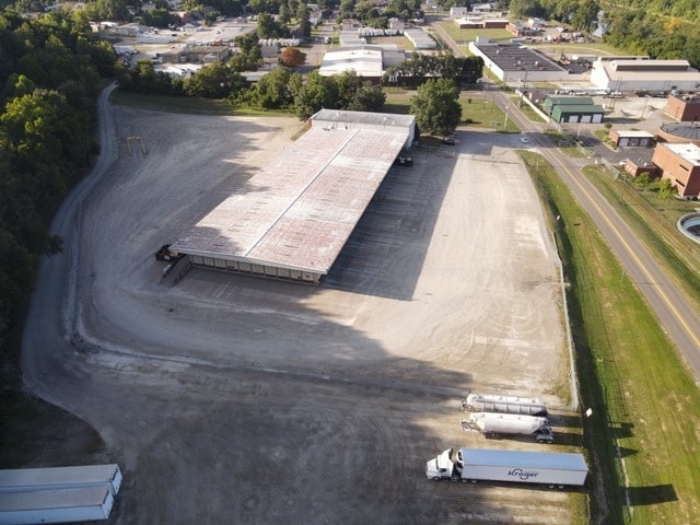
Property Record
1705 Moxahala Ave, Zanesville, OH 43701


Current Lease Availabilities
NEARBY LISTINGS FOR SALE OR LEASE
-
-
View all Zanesville listings for lease on LoopNet.com
Property Detail
1705 Moxahala Ave
81-21-01-06-000
WEST OF MOXAHALA EXTEN
Truckterminal
Muskingum
X
Ohio
39119C0292G
9.50 AC
2024
Ohio South Area
2024
Other Market Areas
912100
Zanesville, OH
45,510 SF
DEMOGRAPHICS near 1705 Moxahala Ave
1 Mile
3 Mile
5 Mile
2024 Total Population
5,480
24,339
42,251
2029 Population
5,506
24,539
42,362
Pop Growth 2024-2029
+ 0.47%
+ 0.82%
+ 0.26%
Average Age
40
39
40
2024 Total Households
2,305
9,908
17,594
HH Growth 2024-2029
+ 0.43%
+ 0.81%
+ 0.26%
Median Household Inc
$44,280
$35,209
$44,049
Avg Household Size
2.30
2.40
2.30
2024 Avg HH Vehicles
2.00
2.00
2.00
Median Home Value
$84,179
$86,973
$118,965
Median Year Built
1952
1951
1957
Nearby Places
Map Layers
Map Styles
 Street
 Aerial
- Restaurants
- Banks
- Shops
- Fitness
- Groceries
Nearby Properties
Address
Land Use
TOTAL SIZE
Lot Size
Zoning
Address
Land Use
TOTAL SIZE
Lot Size
Zoning
1,782 SF
64.80 AC
COMM
Address
Land Use
TOTAL SIZE
Lot Size
Zoning
114,644 SF
7.33 AC
RS2
Address
Land Use
TOTAL SIZE
Lot Size
Zoning
74,956 SF
10.45 AC
RS5
Address
Land Use
TOTAL SIZE
Lot Size
Zoning
6,344 SF
19.56 AC
Address
Land Use
TOTAL SIZE
Lot Size
Zoning
83,031 SF
7.30 AC
RS4
Address
Land Use
TOTAL SIZE
Lot Size
Zoning
184,623 SF
21.08 AC
Address
Land Use
TOTAL SIZE
Lot Size
Zoning
26,455 SF
9.41 AC
Address
Land Use
TOTAL SIZE
Lot Size
Zoning
32,100 SF
2.12 AC
C1
Address
Land Use
TOTAL SIZE
Lot Size
Zoning
17,723 SF
0.94 AC
C4
Address
Land Use
TOTAL SIZE
Lot Size
Zoning
2,772 SF
4.72 AC
RM1
Address
Land Use
TOTAL SIZE
Lot Size
Zoning
52,564 SF
0.80 AC
C3
Address
Land Use
TOTAL SIZE
Lot Size
Zoning
6,662 SF
13.02 AC
I1
Address
Land Use
TOTAL SIZE
Lot Size
Zoning
56,454 SF
1.50 AC
O2
Address
Land Use
TOTAL SIZE
Lot Size
Zoning
61,732 SF
18.46 AC
Address
Land Use
TOTAL SIZE
Lot Size
Zoning
23,857 SF
0.14 AC
C4
Address
Land Use
TOTAL SIZE
Lot Size
Zoning
49,516 SF
3.72 AC
C4
Address
Land Use
TOTAL SIZE
Lot Size
Zoning
51,702 SF
1.69 AC
O2
Address
Land Use
TOTAL SIZE
Lot Size
Zoning
54,300 SF
7.47 AC
Address
Land Use
TOTAL SIZE
Lot Size
Zoning
3.37 AC
I1
Address
Land Use
TOTAL SIZE
Lot Size
Zoning
5,404 SF
15.25 AC
RM1
Address
Land Use
TOTAL SIZE
Lot Size
Zoning
19,574 SF
2.88 AC
C4
Address
Land Use
TOTAL SIZE
Lot Size
Zoning
12,720 SF
5.24 AC
Address
Land Use
TOTAL SIZE
Lot Size
Zoning
132,528 SF
2.27 AC
I1
Address
Land Use
TOTAL SIZE
Lot Size
Zoning
98.11 AC
Address
Land Use
TOTAL SIZE
Lot Size
Zoning
51,740 SF
2.76 AC
I1
Address
Land Use
TOTAL SIZE
Lot Size
Zoning
30,836 SF
0.12 AC
C4
Address
Land Use
TOTAL SIZE
Lot Size
Zoning
16,109 SF
3.75 AC
Address
Land Use
TOTAL SIZE
Lot Size
Zoning
11,900 SF
3.43 AC
RS4
Address
Land Use
TOTAL SIZE
Lot Size
Zoning
32,138 SF
5.36 AC
Address
Land Use
TOTAL SIZE
Lot Size
Zoning
42,400 SF
3.08 AC
C4
The World's #1 Commercial Real Estate Marketplace
Connect with us
© 2025 CoStar Group
The information above has been obtained from sources believed reliable. While we do not doubt its accuracy we have not verified it and make no guarantee, warranty or representation about it. It is your responsibility to independently confirm its accuracy and completeness. Any projections, opinions, assumptions, or estimates used are for example only and do not represent the current or future performance of the property. The value of this transaction to you depends on tax and other factors which should be evaluated by your tax, financial, and legal advisors. You and your advisors should conduct a careful, independent investigation of the property to determine to your satisfaction the suitability of the property for your needs.