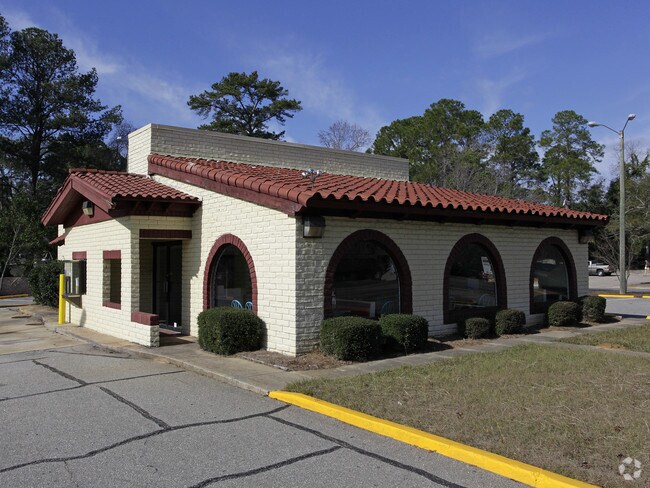
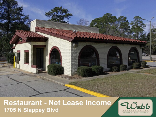
Property Record
1705 N Slappey Blvd, Albany, GA 31701


NEARBY LISTINGS FOR SALE OR LEASE
Property Detail
1705 N Slappey Blvd
Albany, GA
Route 520 Bu North
0000G-00008-009
ALL LOTS 95 & 96 N SLAPPEY HTS
Restaurantbuilding
Dougherty
X
Georgia
13095C0106E
95,96
2025
0.58 AC
2024
Albany/Southwest
001500
Other Market Areas
1,796 SF
DEMOGRAPHICS near 1705 N Slappey Blvd
1 Mile
3 Mile
5 Mile
2024 Total Population
6,392
38,405
75,208
2029 Population
6,035
37,050
73,086
Pop Growth 2024-2029
(5.59%)
(3.53%)
(2.82%)
Average Age
39
39
38
2024 Total Households
2,903
16,796
30,959
HH Growth 2024-2029
(5.51%)
(3.69%)
(3.04%)
Median Household Inc
$50,034
$46,065
$45,440
Avg Household Size
2.10
2.20
2.30
2024 Avg HH Vehicles
1.00
1.00
2.00
Median Home Value
$90,529
$126,332
$137,781
Median Year Built
1957
1973
1977
Nearby Places
Map Layers
Map Styles
 Street
 Aerial
- Restaurants
- Banks
- Shops
- Fitness
- Groceries
PUBLIC TRANSPORTATION
AIRPORT
Southwest Georgia Regional
DRIVE
WALK
Distance
Southwest Georgia Regional
12 min
5.5 mi
Freight Ports
Port of Panama City
DRIVE
WALK
Distance
Port of Panama City
232 min
159.8 mi
SALE & LEASE HISTORY
LISTING DATE
SALE/LEASE

Nov 29, 2018
For Lease
Nov 16, 2021
For Sale
Nearby Properties
Address
Land Use
TOTAL SIZE
Lot Size
Zoning
Address
Land Use
TOTAL SIZE
Lot Size
Zoning
Address
Land Use
TOTAL SIZE
Lot Size
Zoning
126,650 SF
19.41 AC
C2
Address
Land Use
TOTAL SIZE
Lot Size
Zoning
51,008 SF
19.48 AC
C5
Address
Land Use
TOTAL SIZE
Lot Size
Zoning
274,484 SF
16.31 AC
C5
Address
Land Use
TOTAL SIZE
Lot Size
Zoning
1.77 AC
C2
Address
Land Use
TOTAL SIZE
Lot Size
Zoning
15.20 AC
C2
Address
Land Use
TOTAL SIZE
Lot Size
Zoning
42,880 SF
31.25 AC
R6
Address
Land Use
TOTAL SIZE
Lot Size
Zoning
2.53 AC
C2
Address
Land Use
TOTAL SIZE
Lot Size
Zoning
1.75 AC
C2
Address
Land Use
TOTAL SIZE
Lot Size
Zoning
186,956 SF
29.23 AC
R6
Address
Land Use
TOTAL SIZE
Lot Size
Zoning
147,258 SF
36.94 AC
C7
Address
Land Use
TOTAL SIZE
Lot Size
Zoning
0.83 AC
C2
Address
Land Use
TOTAL SIZE
Lot Size
Zoning
224,080 SF
21.72 AC
COMMERCIAL
Address
Land Use
TOTAL SIZE
Lot Size
Zoning
1,752 SF
13.25 AC
RESIDENTIA
Address
Land Use
TOTAL SIZE
Lot Size
Zoning
131,385 SF
21.89 AC
C3
Address
Land Use
TOTAL SIZE
Lot Size
Zoning
77,688 SF
2.93 AC
C3
Address
Land Use
TOTAL SIZE
Lot Size
Zoning
70,596 SF
2.38 AC
C2
Address
Land Use
TOTAL SIZE
Lot Size
Zoning
232,840 SF
49.88 AC
M1
Address
Land Use
TOTAL SIZE
Lot Size
Zoning
88,144 SF
12.47 AC
C2
Address
Land Use
TOTAL SIZE
Lot Size
Zoning
0.54 AC
C2
Address
Land Use
TOTAL SIZE
Lot Size
Zoning
107,500 SF
11.27 AC
C2
Address
Land Use
TOTAL SIZE
Lot Size
Zoning
9,676 SF
10.73 AC
R6
Address
Land Use
TOTAL SIZE
Lot Size
Zoning
129,973 SF
21.89 AC
C3
Address
Land Use
TOTAL SIZE
Lot Size
Zoning
21,760 SF
10.76 AC
R6
Address
Land Use
TOTAL SIZE
Lot Size
Zoning
21,144 SF
11.79 AC
R6
Address
Land Use
TOTAL SIZE
Lot Size
Zoning
44,671 SF
4 AC
C2
Address
Land Use
TOTAL SIZE
Lot Size
Zoning
9,216 SF
14.31 AC
COMMERCIAL
Address
Land Use
TOTAL SIZE
Lot Size
Zoning
5,768 SF
16.40 AC
R6
Address
Land Use
TOTAL SIZE
Lot Size
Zoning
32,000 SF
14.19 AC
R1A
Address
Land Use
TOTAL SIZE
Lot Size
Zoning
19,104 SF
10.81 AC
R6
The World's #1 Commercial Real Estate Marketplace
Connect with us
© 2026 CoStar Group
The information above has been obtained from sources believed reliable. While we do not doubt its accuracy we have not verified it and make no guarantee, warranty or representation about it. It is your responsibility to independently confirm its accuracy and completeness. Any projections, opinions, assumptions, or estimates used are for example only and do not represent the current or future performance of the property. The value of this transaction to you depends on tax and other factors which should be evaluated by your tax, financial, and legal advisors. You and your advisors should conduct a careful, independent investigation of the property to determine to your satisfaction the suitability of the property for your needs.