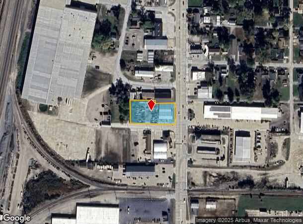
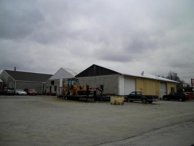
Property Record
1705 S Banker St, Effingham, IL 62401

NEARBY LISTINGS FOR SALE OR LEASE
-
-
View all Effingham listings for sale on LoopNet.com
Property Detail
1705 S Banker St
Effingham, IL
Dorothy Chaplin's Subdivision
0311029012
LOTS 1 THRU 7 DOROTHY CHAPLIN'S SUBD EXCEPT PT N 19.45FT LOTS 1 & 4 THEREOF 3165/343 3140/201 3020/205 2836/318 2301/40 2186/
Commercialnec
Effingham
X
Illinois
17049C0181D
1-7
2024
0.80 AC
2024
Effingham/Central Illinois Area
950800
Other Market Areas
6,875 SF
DEMOGRAPHICS near 1705 S Banker St
1 Mile
3 Mile
5 Mile
2024 Total Population
4,145
12,761
19,677
2029 Population
4,160
12,701
19,553
Pop Growth 2024-2029
+ 0.36%
(0.47%)
(0.63%)
Average Age
40
41
41
2024 Total Households
1,834
5,624
8,282
HH Growth 2024-2029
+ 0.33%
(0.50%)
(0.66%)
Median Household Inc
$54,500
$57,398
$64,289
Avg Household Size
2.20
2.20
2.30
2024 Avg HH Vehicles
2.00
2.00
2.00
Median Home Value
$129,150
$155,500
$174,696
Median Year Built
1958
1974
1976
Nearby Places
Map Layers
Map Styles
 Street
 Aerial
- Restaurants
- Banks
- Shops
- Fitness
- Groceries
PUBLIC TRANSPORTATION
COMMUTER RAIL
Effingham Amtrak Station (City of New Orleans - Amtrak, Illini - Amtrak, Saluki - Amtrak)
DRIVE
WALK
Distance
Effingham Amtrak Station (City of New Orleans - Amtrak, Illini - Amtrak, Saluki - Amtrak)
3 min
1.4 mi
Freight Ports
Port Milwaukee
DRIVE
WALK
Distance
Port Milwaukee
338 min
296.1 mi
Nearby Properties
Address
Land Use
TOTAL SIZE
Lot Size
Zoning
Address
Land Use
TOTAL SIZE
Lot Size
Zoning
1,241,292 SF
71.55 AC
Address
Land Use
TOTAL SIZE
Lot Size
Zoning
66,544 SF
5.07 AC
Address
Land Use
TOTAL SIZE
Lot Size
Zoning
224,208 SF
19.77 AC
Address
Land Use
TOTAL SIZE
Lot Size
Zoning
181,409 SF
24.78 AC
Address
Land Use
TOTAL SIZE
Lot Size
Zoning
424,235 SF
33.26 AC
Address
Land Use
TOTAL SIZE
Lot Size
Zoning
65,800 SF
8.43 AC
Address
Land Use
TOTAL SIZE
Lot Size
Zoning
591,424 SF
36.44 AC
Address
Land Use
TOTAL SIZE
Lot Size
Zoning
34,582 SF
25.60 AC
Address
Land Use
TOTAL SIZE
Lot Size
Zoning
125,446 SF
15 AC
Address
Land Use
TOTAL SIZE
Lot Size
Zoning
91,320 SF
42.69 AC
Address
Land Use
TOTAL SIZE
Lot Size
Zoning
23,312 SF
14.48 AC
Address
Land Use
TOTAL SIZE
Lot Size
Zoning
137,494 SF
13.01 AC
Address
Land Use
TOTAL SIZE
Lot Size
Zoning
80,075 SF
3.26 AC
Address
Land Use
TOTAL SIZE
Lot Size
Zoning
224,578 SF
20.96 AC
Address
Land Use
TOTAL SIZE
Lot Size
Zoning
100,842 SF
10.80 AC
Address
Land Use
TOTAL SIZE
Lot Size
Zoning
68,674 SF
4.69 AC
Address
Land Use
TOTAL SIZE
Lot Size
Zoning
54,632 SF
6.24 AC
Address
Land Use
TOTAL SIZE
Lot Size
Zoning
65,712 SF
2.36 AC
Address
Land Use
TOTAL SIZE
Lot Size
Zoning
15,637 SF
2.19 AC
Address
Land Use
TOTAL SIZE
Lot Size
Zoning
32,923 SF
7.04 AC
Address
Land Use
TOTAL SIZE
Lot Size
Zoning
37,248 SF
6.72 AC
Address
Land Use
TOTAL SIZE
Lot Size
Zoning
187,652 SF
33.51 AC
Address
Land Use
TOTAL SIZE
Lot Size
Zoning
56,333 SF
6.20 AC
Address
Land Use
TOTAL SIZE
Lot Size
Zoning
56,553 SF
7.13 AC
Address
Land Use
TOTAL SIZE
Lot Size
Zoning
200,792 SF
13.03 AC
Address
Land Use
TOTAL SIZE
Lot Size
Zoning
165,473 SF
10 AC
Address
Land Use
TOTAL SIZE
Lot Size
Zoning
41,734 SF
2.77 AC
Address
Land Use
TOTAL SIZE
Lot Size
Zoning
52,260 SF
2.20 AC
Address
Land Use
TOTAL SIZE
Lot Size
Zoning
42,439 SF
6.29 AC
Address
Land Use
TOTAL SIZE
Lot Size
Zoning
17,611 SF
15.97 AC
The World's #1 Commercial Real Estate Marketplace
Connect with us
© 2025 CoStar Group
The information above has been obtained from sources believed reliable. While we do not doubt its accuracy we have not verified it and make no guarantee, warranty or representation about it. It is your responsibility to independently confirm its accuracy and completeness. Any projections, opinions, assumptions, or estimates used are for example only and do not represent the current or future performance of the property. The value of this transaction to you depends on tax and other factors which should be evaluated by your tax, financial, and legal advisors. You and your advisors should conduct a careful, independent investigation of the property to determine to your satisfaction the suitability of the property for your needs.