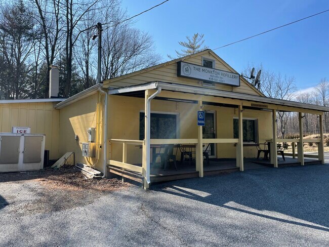
Property Record
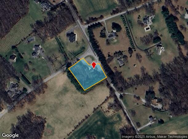
17052 Troyer Rd, Monkton, MD 21111
NEARBY LISTINGS FOR SALE OR LEASE
-
-
View all Monkton listings for lease on LoopNet.com
Property Detail
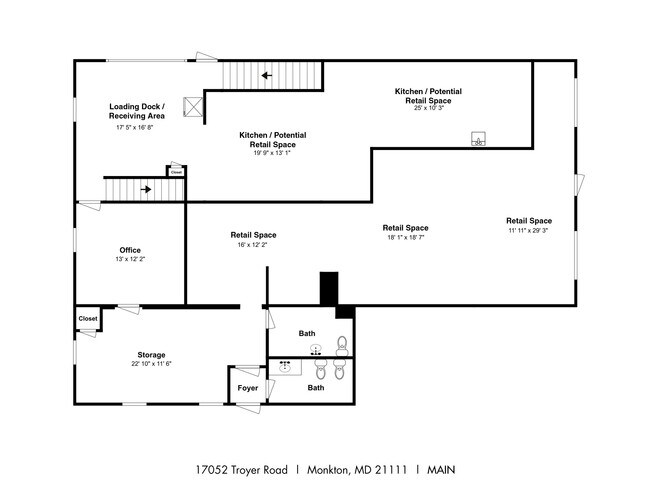
17052 Troyer Rd
10-1026040240
1.50 AC
Storebuilding
Baltimore
X
Maryland
2400100130G
1.50 AC
2024
Route 83 Corridor North
2025
Baltimore
410100
Baltimore-Columbia-Towson, MD
2,299 SF
DEMOGRAPHICS near 17052 Troyer Rd
1 Mile
3 Mile
5 Mile
2024 Total Population
177
2,857
12,769
2029 Population
172
2,819
12,714
Pop Growth 2024-2029
(2.82%)
(1.33%)
(0.43%)
Average Age
45
45
44
2024 Total Households
69
1,092
4,584
HH Growth 2024-2029
(4.35%)
(1.28%)
(0.48%)
Median Household Inc
$109,722
$119,134
$130,673
Avg Household Size
2.50
2.60
2.70
2024 Avg HH Vehicles
3.00
3.00
3.00
Median Home Value
$608,108
$623,168
$514,036
Median Year Built
1987
1978
1978
Nearby Places
Map Layers
Map Styles
 Street
 Aerial
- Restaurants
- Banks
- Shops
- Fitness
- Groceries
PUBLIC TRANSPORTATION
AIRPORT
Baltimore/Washington International Thurgood Marshall
DRIVE
WALK
Distance
Baltimore/Washington International Thurgood Marshall
63 min
42.0 mi
Freight Ports
Port of Baltimore
DRIVE
WALK
Distance
Port of Baltimore
55 min
32.5 mi
SALE & LEASE HISTORY
LISTING DATE
SALE/LEASE

Sep 23, 2016
For Sale
Nov 20, 2019
For Sale
Mar 03, 2022
For Lease
Mar 03, 2022
For Sale
Jul 13, 2018
For Sale
Nearby Properties
Address
Land Use
TOTAL SIZE
Lot Size
Zoning
Address
Land Use
TOTAL SIZE
Lot Size
Zoning
22,697 SF
92.32 AC
Address
Land Use
TOTAL SIZE
Lot Size
Zoning
14,036 SF
129.69 AC
Address
Land Use
TOTAL SIZE
Lot Size
Zoning
10,709 SF
90.27 AC
Address
Land Use
TOTAL SIZE
Lot Size
Zoning
4,227 SF
14.65 AC
Address
Land Use
TOTAL SIZE
Lot Size
Zoning
11,674 SF
104.39 AC
Address
Land Use
TOTAL SIZE
Lot Size
Zoning
9,241 SF
18.53 AC
RC2
Address
Land Use
TOTAL SIZE
Lot Size
Zoning
10,369 SF
23.16 AC
RC2
Address
Land Use
TOTAL SIZE
Lot Size
Zoning
7,308 SF
54.87 AC
Address
Land Use
TOTAL SIZE
Lot Size
Zoning
4,703 SF
78.19 AC
Address
Land Use
TOTAL SIZE
Lot Size
Zoning
6,755 SF
10.45 AC
Address
Land Use
TOTAL SIZE
Lot Size
Zoning
5,869 SF
10.03 AC
Address
Land Use
TOTAL SIZE
Lot Size
Zoning
6,551 SF
18 AC
Address
Land Use
TOTAL SIZE
Lot Size
Zoning
6,240 SF
16.61 AC
Address
Land Use
TOTAL SIZE
Lot Size
Zoning
7,088 SF
15.12 AC
Address
Land Use
TOTAL SIZE
Lot Size
Zoning
7,693 SF
46.37 AC
Address
Land Use
TOTAL SIZE
Lot Size
Zoning
5,252 SF
107.92 AC
Address
Land Use
TOTAL SIZE
Lot Size
Zoning
6,505 SF
10 AC
Address
Land Use
TOTAL SIZE
Lot Size
Zoning
4,354 SF
71.23 AC
Address
Land Use
TOTAL SIZE
Lot Size
Zoning
5,533 SF
21.16 AC
Address
Land Use
TOTAL SIZE
Lot Size
Zoning
6,953 SF
66.41 AC
RC2
Address
Land Use
TOTAL SIZE
Lot Size
Zoning
7,645 SF
62.50 AC
Address
Land Use
TOTAL SIZE
Lot Size
Zoning
4,896 SF
12.31 AC
Address
Land Use
TOTAL SIZE
Lot Size
Zoning
5,648 SF
42.72 AC
Address
Land Use
TOTAL SIZE
Lot Size
Zoning
9,835 SF
14.16 AC
Address
Land Use
TOTAL SIZE
Lot Size
Zoning
6,633 SF
10.53 AC
Address
Land Use
TOTAL SIZE
Lot Size
Zoning
4,955 SF
10 AC
RC2
Address
Land Use
TOTAL SIZE
Lot Size
Zoning
7.59 AC
AG
Address
Land Use
TOTAL SIZE
Lot Size
Zoning
5,038 SF
87.63 AC
Address
Land Use
TOTAL SIZE
Lot Size
Zoning
5,981 SF
18.52 AC
Address
Land Use
TOTAL SIZE
Lot Size
Zoning
7,508 SF
18.20 AC
The World's #1 Commercial Real Estate Marketplace
Connect with us
© 2026 CoStar Group
The information above has been obtained from sources believed reliable. While we do not doubt its accuracy we have not verified it and make no guarantee, warranty or representation about it. It is your responsibility to independently confirm its accuracy and completeness. Any projections, opinions, assumptions, or estimates used are for example only and do not represent the current or future performance of the property. The value of this transaction to you depends on tax and other factors which should be evaluated by your tax, financial, and legal advisors. You and your advisors should conduct a careful, independent investigation of the property to determine to your satisfaction the suitability of the property for your needs.