Property Record
1706 E 1300 S, Salt Lake City, UT 84108

NEARBY LISTINGS FOR SALE OR LEASE
Property Detail
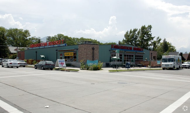
1706 E 1300 S
Salt Lake City-Murray, UT
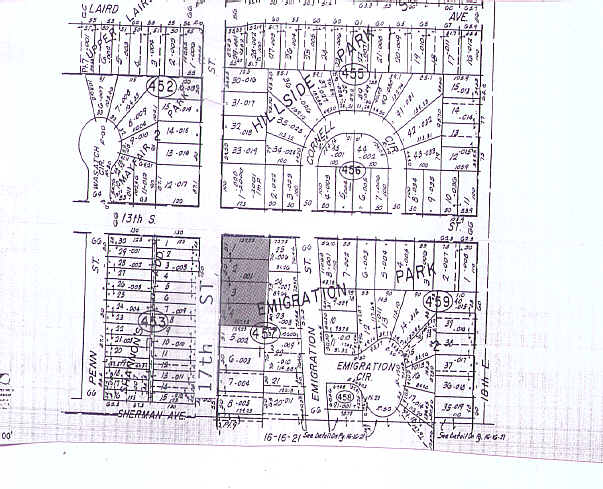
Emigration Park
16-09-457-001-0000
LOTS 1 THRU 4, BLK 1, EMIGRATION PARK 4588-0127 6387-2410 8308-3481
Storebuilding
Salt Lake
X
Utah
49035C0302H
1-4
2024
0.63 AC
2025
Foothill Corridor
104000
Salt Lake City
9,645 SF
DEMOGRAPHICS near 1706 E 1300 S
1 Mile
3 Mile
5 Mile
2024 Total Population
18,642
136,059
262,116
2029 Population
18,528
137,856
266,119
Pop Growth 2024-2029
(0.61%)
+ 1.32%
+ 1.53%
Average Age
38
37
38
2024 Total Households
6,981
61,068
112,788
HH Growth 2024-2029
(0.82%)
+ 1.61%
+ 1.86%
Median Household Inc
$103,299
$70,451
$69,021
Avg Household Size
2.50
2.10
2.20
2024 Avg HH Vehicles
2.00
2.00
2.00
Median Home Value
$727,200
$600,700
$544,540
Median Year Built
1948
1959
1966
Nearby Places
Map Layers
Map Styles
 Street
 Aerial
- Restaurants
- Banks
- Shops
- Fitness
- Groceries
PUBLIC TRANSPORTATION
COMMUTER RAIL
North Temple Station (FrontRunner - Utah Transit Authority (UTA))
DRIVE
WALK
Distance
North Temple Station (FrontRunner - Utah Transit Authority (UTA))
14 min
5.5 mi
Warm Springs Relief Point (FrontRunner - Utah Transit Authority (UTA))
DRIVE
WALK
Distance
Warm Springs Relief Point (FrontRunner - Utah Transit Authority (UTA))
17 min
7.4 mi
AIRPORT
Salt Lake City International
DRIVE
WALK
Distance
Salt Lake City International
20 min
10.0 mi
Freight Ports
Port of Stockton
DRIVE
WALK
Distance
Port of Stockton
720 min
700.3 mi
Nearby Properties
Address
Land Use
TOTAL SIZE
Lot Size
Zoning
Address
Land Use
TOTAL SIZE
Lot Size
Zoning
2,287,331 SF
137 AC
I
Address
Land Use
TOTAL SIZE
Lot Size
Zoning
1,260,285 SF
59.07 AC
I
Address
Land Use
TOTAL SIZE
Lot Size
Zoning
591,924 SF
80.77 AC
I
Address
Land Use
TOTAL SIZE
Lot Size
Zoning
298,342 SF
13.71 AC
I
Address
Land Use
TOTAL SIZE
Lot Size
Zoning
1,262,865 SF
44.15 AC
I
Address
Land Use
TOTAL SIZE
Lot Size
Zoning
530,605 SF
127 AC
RP
Address
Land Use
TOTAL SIZE
Lot Size
Zoning
365,253 SF
33.64 AC
I
Address
Land Use
TOTAL SIZE
Lot Size
Zoning
295,047 SF
113.27 AC
RP
Address
Land Use
TOTAL SIZE
Lot Size
Zoning
87,933 SF
4.90 AC
D-1
Address
Land Use
TOTAL SIZE
Lot Size
Zoning
185,202 SF
51.07 AC
J
Address
Land Use
TOTAL SIZE
Lot Size
Zoning
2,566,335 SF
10.01 AC
D-1
Address
Land Use
TOTAL SIZE
Lot Size
Zoning
298,628 SF
27.30 AC
I
Address
Land Use
TOTAL SIZE
Lot Size
Zoning
807,940 SF
0.69 AC
D1
Address
Land Use
TOTAL SIZE
Lot Size
Zoning
299,535 SF
38 AC
I
Address
Land Use
TOTAL SIZE
Lot Size
Zoning
254,939 SF
34.68 AC
I
Address
Land Use
TOTAL SIZE
Lot Size
Zoning
1,256,042 SF
3.50 AC
D-1
Address
Land Use
TOTAL SIZE
Lot Size
Zoning
82,851 SF
9.76 AC
PL2
Address
Land Use
TOTAL SIZE
Lot Size
Zoning
440,898 SF
0.01 AC
RP
Address
Land Use
TOTAL SIZE
Lot Size
Zoning
588,291 SF
1.28 AC
D-1
Address
Land Use
TOTAL SIZE
Lot Size
Zoning
434,481 SF
10 AC
D-1
Address
Land Use
TOTAL SIZE
Lot Size
Zoning
497,018 SF
13.11 AC
I
Address
Land Use
TOTAL SIZE
Lot Size
Zoning
163,932 SF
14.65 AC
PL
Address
Land Use
TOTAL SIZE
Lot Size
Zoning
95,666 SF
52.19 AC
I
Address
Land Use
TOTAL SIZE
Lot Size
Zoning
8,042 SF
64.58 AC
RP
Address
Land Use
TOTAL SIZE
Lot Size
Zoning
37,536 SF
10 AC
PL
Address
Land Use
TOTAL SIZE
Lot Size
Zoning
208,868 SF
20.41 AC
I
Address
Land Use
TOTAL SIZE
Lot Size
Zoning
183,600 SF
10.70 AC
RMF-35
Address
Land Use
TOTAL SIZE
Lot Size
Zoning
249,796 SF
49.02 AC
I
Address
Land Use
TOTAL SIZE
Lot Size
Zoning
115,169 SF
119.06 AC
RP
Address
Land Use
TOTAL SIZE
Lot Size
Zoning
128,997 SF
3.04 AC
ESN
The World's #1 Commercial Real Estate Marketplace
Connect with us
© 2026 CoStar Group
The information above has been obtained from sources believed reliable. While we do not doubt its accuracy we have not verified it and make no guarantee, warranty or representation about it. It is your responsibility to independently confirm its accuracy and completeness. Any projections, opinions, assumptions, or estimates used are for example only and do not represent the current or future performance of the property. The value of this transaction to you depends on tax and other factors which should be evaluated by your tax, financial, and legal advisors. You and your advisors should conduct a careful, independent investigation of the property to determine to your satisfaction the suitability of the property for your needs.