Property Record
1706 Goetz Rd, Perris, CA 92570
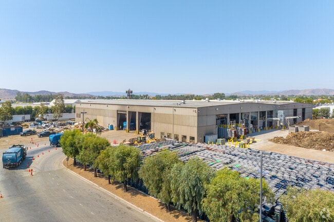

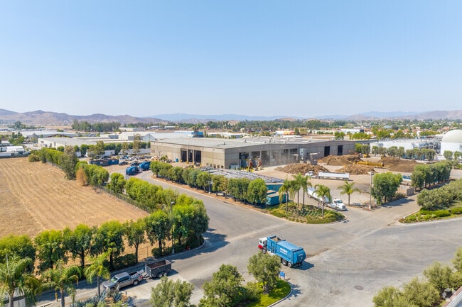
Property Detail
1706 Goetz Rd
Riverside-San Bernardino-Ontario, CA
51.69 ACRES IN POR PARS 1, 2, 3 & 4 RS 016/014 AND POR NE 1/4 OF SEC 6 T5S R3W FOR TOTAL DESCRIPTION SEE ASSESSORS MAPS
330-030-020
Riverside
Lightindustrial
California
B and X Area of moderate flood hazard, usually the area between the limits of the 100-year and 500-year floods.
1
2024
51.69 AC
2025
Moreno Valley/Perris
042907
Inland Empire (California)
57,600 SF
NEARBY LISTINGS FOR SALE OR LEASE
DEMOGRAPHICS near 1706 Goetz Rd
1 mile
3 mile
5 mile
2025 Total Population
7,986
52,971
120,817
2030 Population
8,265
54,483
124,323
Pop Growth 2025-2030
+ 3.49%
+ 2.85%
+ 2.90%
Average Age
32
34
37
2025 Total Households
1,969
13,075
33,787
HH Growth 2025-2030
+ 3.50%
+ 2.77%
+ 2.68%
Median Household Inc
$81,179
$75,338
$74,963
Avg Household Size
4.00
3.90
3.40
2025 Avg HH Vehicles
2.00
2.00
2.00
Median Home Value
$431,021
$443,379
$444,865
Median Year Built
1984
1991
1990
Nearby Places
Map Layers
Map Styles
 Street
 Aerial
Layers
 Traffic
 Biking
Places
Listings with unknown addresses are not visible on the map
- Restaurants
- Banks
- Shops
- Fitness
- Groceries
PUBLIC TRANSPORTATION
COMMUTER RAIL
Perris Downtown (Metrolink 91-Perris Valley Line - Metrolink Trains)
Drive
Walk
Distance
Perris Downtown (Metrolink 91-Perris Valley Line - Metrolink Trains)
4 min
1.6 mi
South Perris (Metrolink 91-Perris Valley Line - Metrolink Trains)
Drive
Walk
Distance
South Perris (Metrolink 91-Perris Valley Line - Metrolink Trains)
3 min
1.8 mi
AIRPORT
Ontario International
Drive
Walk
Distance
Ontario International
45 min
35.5 mi
Freight Ports
Port of Long Beach
Drive
Walk
Distance
Port of Long Beach
95 min
70.2 mi
Nearby Properties
Address
Land Use
TOTAL SIZE
Lot Size
Zoning
Address
Land Use
TOTAL SIZE
Lot Size
Zoning
28.13 AC
RR
Address
Land Use
TOTAL SIZE
Lot Size
Zoning
197,865 SF
10.74 AC
Address
Land Use
TOTAL SIZE
Lot Size
Zoning
34.84 AC
Address
Land Use
TOTAL SIZE
Lot Size
Zoning
187,889 SF
20.64 AC
Address
Land Use
TOTAL SIZE
Lot Size
Zoning
32,709 SF
4.61 AC
C2
Address
Land Use
TOTAL SIZE
Lot Size
Zoning
104,208 SF
10.96 AC
Address
Land Use
TOTAL SIZE
Lot Size
Zoning
89,409 SF
6.18 AC
Address
Land Use
TOTAL SIZE
Lot Size
Zoning
207,130 SF
16.15 AC
Address
Land Use
TOTAL SIZE
Lot Size
Zoning
22,119 SF
4.59 AC
R3
Address
Land Use
TOTAL SIZE
Lot Size
Zoning
75,109 SF
9.39 AC
Address
Land Use
TOTAL SIZE
Lot Size
Zoning
1,080 SF
9.53 AC
A02
Address
Land Use
TOTAL SIZE
Lot Size
Zoning
122,824 SF
5.18 AC
CC
Address
Land Use
TOTAL SIZE
Lot Size
Zoning
13.95 AC
Address
Land Use
TOTAL SIZE
Lot Size
Zoning
50,000 SF
5.36 AC
CC
Address
Land Use
TOTAL SIZE
Lot Size
Zoning
47,440 SF
5.32 AC
C2
Address
Land Use
TOTAL SIZE
Lot Size
Zoning
1,018,178 SF
57.91 AC
Address
Land Use
TOTAL SIZE
Lot Size
Zoning
3,750 SF
37.79 AC
GI
Address
Land Use
TOTAL SIZE
Lot Size
Zoning
97,942 SF
11 AC
Address
Land Use
TOTAL SIZE
Lot Size
Zoning
201,496 SF
13.35 AC
LI
Address
Land Use
TOTAL SIZE
Lot Size
Zoning
7,250 SF
2.35 AC
Address
Land Use
TOTAL SIZE
Lot Size
Zoning
35,600 SF
3.19 AC
Address
Land Use
TOTAL SIZE
Lot Size
Zoning
41,840 SF
8.92 AC
The World's #1 Commercial Real Estate Marketplace
Connect with us
© 2026 CoStar Group
The information above has been obtained from sources believed reliable. While we do not doubt its accuracy we have not verified it and make no guarantee, warranty or representation about it. It is your responsibility to independently confirm its accuracy and completeness. Any projections, opinions, assumptions, or estimates used are for example only and do not represent the current or future performance of the property. The value of this transaction to you depends on tax and other factors which should be evaluated by your tax, financial, and legal advisors. You and your advisors should conduct a careful, independent investigation of the property to determine to your satisfaction the suitability of the property for your needs.