Property Record
1706 Springfield Rd, Bloomington, IL 61701
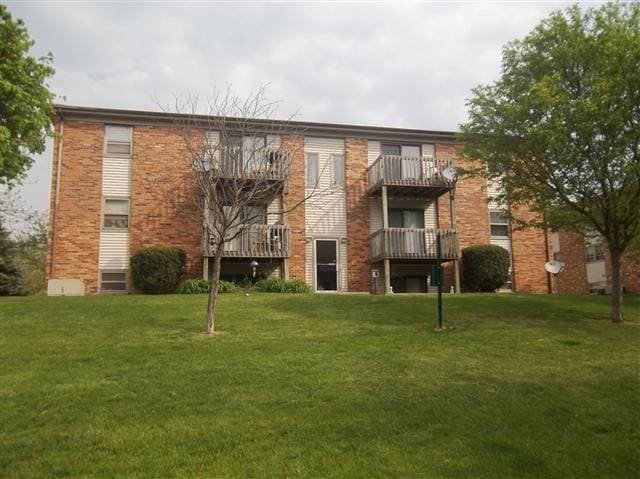

Property Detail
1706 Springfield Rd
Bloomington, IL
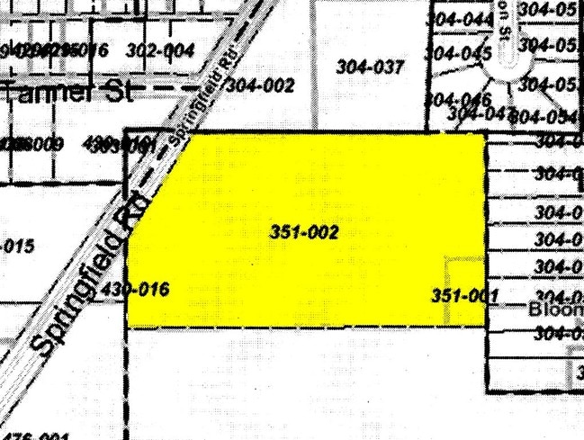
COUNTY CLERKS SUB OF LOTS 6 & 16 SEC 9-23-2E LOT 1 & SUB OF SE 8-23-2E - THAT PT LOT 8 LYG ELY OF SPRINGFIELD RD 5.42 ACRES
21-09-351-005
McLean
Commercialacreage
Illinois
AE The base floodplain where base flood elevations are provided. AE Zones are now used on new format FIRMs instead of A1-A30 Zones.
6,16
2022
5.42 AC
2024
Bloomington/Normal
005900
Other Market Areas
95,256 SF
NEARBY LISTINGS FOR SALE OR LEASE
DEMOGRAPHICS near 1706 Springfield Rd
1 mile
3 mile
5 mile
2025 Total Population
11,953
58,249
115,666
2030 Population
12,166
58,741
116,006
Pop Growth 2025-2030
+ 1.78%
+ 0.84%
+ 0.29%
Average Age
39
38
37
2025 Total Households
5,353
25,599
47,833
HH Growth 2025-2030
+ 1.83%
+ 0.86%
+ 0.34%
Median Household Inc
$52,143
$57,283
$65,997
Avg Household Size
2.10
2.10
2.20
2025 Avg HH Vehicles
2.00
2.00
2.00
Median Home Value
$137,853
$165,644
$196,616
Median Year Built
1967
1970
1978
Nearby Places
Map Layers
Map Styles
 Street
 Aerial
Transit
 Traffic
 Biking
Places
Listings with unknown addresses are not visible on the map
- Restaurants
- Banks
- Shops
- Fitness
- Groceries
PUBLIC TRANSPORTATION
COMMUTER RAIL
Bloomington-Normal (Lincoln Service - Amtrak, Lincoln Service Missouri River Runner - Amtrak, Texas Eagle - Amtrak)
Drive
Walk
Distance
Bloomington-Normal (Lincoln Service - Amtrak, Lincoln Service Missouri River Runner - Amtrak, Texas Eagle - Amtrak)
10 min
3.7 mi
AIRPORT
Central Il Regional/Bloomington-Normal
Drive
Walk
Distance
Central Il Regional/Bloomington-Normal
17 min
6.7 mi
Freight Ports
Port Milwaukee
Drive
Walk
Distance
Port Milwaukee
248 min
212.1 mi
Nearby Properties
Address
Land Use
TOTAL SIZE
Lot Size
Zoning
Address
Land Use
TOTAL SIZE
Lot Size
Zoning
131.22 AC
Address
Land Use
TOTAL SIZE
Lot Size
Zoning
1,867,780 SF
48.61 AC
Address
Land Use
TOTAL SIZE
Lot Size
Zoning
682,885 SF
44.48 AC
Address
Land Use
TOTAL SIZE
Lot Size
Zoning
493,944 SF
2.95 AC
R-3A
Address
Land Use
TOTAL SIZE
Lot Size
Zoning
445,676 SF
20.86 AC
Address
Land Use
TOTAL SIZE
Lot Size
Zoning
1,624,618 SF
54.32 AC
Address
Land Use
TOTAL SIZE
Lot Size
Zoning
333,419 SF
35.07 AC
Address
Land Use
TOTAL SIZE
Lot Size
Zoning
351,208 SF
15.91 AC
Address
Land Use
TOTAL SIZE
Lot Size
Zoning
126,418 SF
1.06 AC
Address
Land Use
TOTAL SIZE
Lot Size
Zoning
432,093 SF
15 AC
Address
Land Use
TOTAL SIZE
Lot Size
Zoning
10.13 AC
R2
Address
Land Use
TOTAL SIZE
Lot Size
Zoning
228,378 SF
7.99 AC
Address
Land Use
TOTAL SIZE
Lot Size
Zoning
733,822 SF
18.01 AC
Address
Land Use
TOTAL SIZE
Lot Size
Zoning
422,234 SF
23.17 AC
Address
Land Use
TOTAL SIZE
Lot Size
Zoning
200,445 SF
8.33 AC
Address
Land Use
TOTAL SIZE
Lot Size
Zoning
275,860 SF
12.17 AC
Address
Land Use
TOTAL SIZE
Lot Size
Zoning
276,695 SF
12.68 AC
Address
Land Use
TOTAL SIZE
Lot Size
Zoning
388,851 SF
4.40 AC
Address
Land Use
TOTAL SIZE
Lot Size
Zoning
191,880 SF
3 AC
B-1
Address
Land Use
TOTAL SIZE
Lot Size
Zoning
2,907 SF
96.29 AC
Address
Land Use
TOTAL SIZE
Lot Size
Zoning
399,682 SF
18.08 AC
Address
Land Use
TOTAL SIZE
Lot Size
Zoning
51,320 SF
0.70 AC
B-1
Address
Land Use
TOTAL SIZE
Lot Size
Zoning
118,176 SF
2.30 AC
Address
Land Use
TOTAL SIZE
Lot Size
Zoning
97,514 SF
2.70 AC
Address
Land Use
TOTAL SIZE
Lot Size
Zoning
101,129 SF
1.49 AC
Address
Land Use
TOTAL SIZE
Lot Size
Zoning
51,320 SF
0.50 AC
B-1
Address
Land Use
TOTAL SIZE
Lot Size
Zoning
336,536 SF
10.98 AC
Address
Land Use
TOTAL SIZE
Lot Size
Zoning
98,540 SF
6.49 AC
Address
Land Use
TOTAL SIZE
Lot Size
Zoning
126,428 SF
3.79 AC
The World's #1 Commercial Real Estate Marketplace
Connect with us
© 2026 CoStar Group
The information above has been obtained from sources believed reliable. While we do not doubt its accuracy we have not verified it and make no guarantee, warranty or representation about it. It is your responsibility to independently confirm its accuracy and completeness. Any projections, opinions, assumptions, or estimates used are for example only and do not represent the current or future performance of the property. The value of this transaction to you depends on tax and other factors which should be evaluated by your tax, financial, and legal advisors. You and your advisors should conduct a careful, independent investigation of the property to determine to your satisfaction the suitability of the property for your needs.