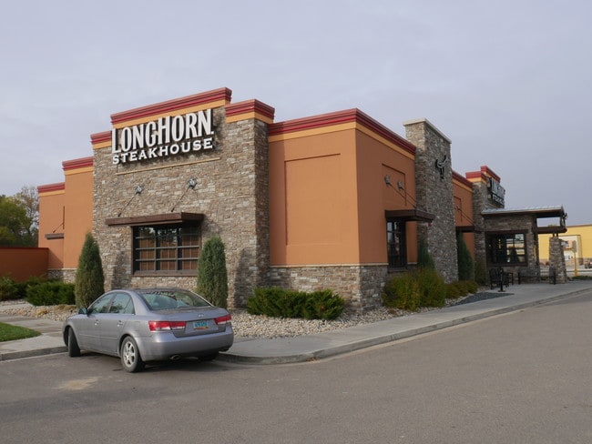
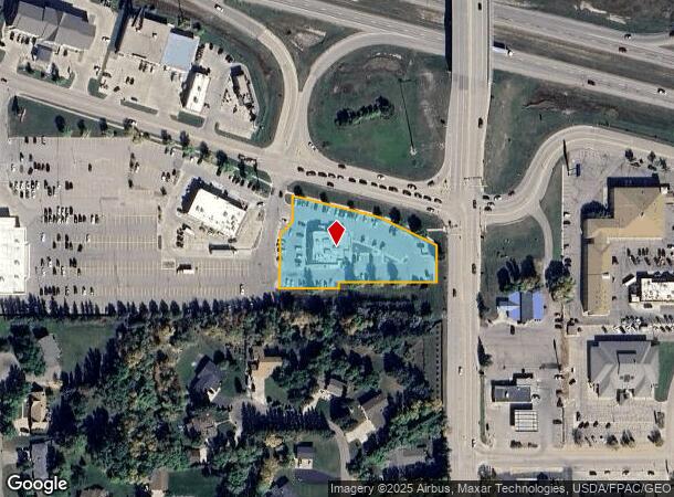
Property Record
1707 22Nd Ave Sw, Minot, ND 58701
NEARBY LISTINGS FOR SALE OR LEASE
Property Detail
1707 22Nd Ave Sw
Other Market Areas
West Dakota Acres
Minot, ND
SUB: MI34A80 WEST DAKOTA ACRES 2ND ADDITION LOT 3
MI-34A80-000-003-0
Ward
Singlefamilyresidentialassumed
North Dakota
2024
3
2024
1.36 AC
010601
Souris Valley
6,263 SF
DEMOGRAPHICS near 1707 22Nd Ave Sw
1 mile
3 mile
5 mile
2024 Total Population
6,645
35,563
52,125
2029 Population
6,529
34,989
51,351
Pop Growth 2024-2029
(1.75%)
(1.61%)
(1.48%)
Average Age
44
39
38
2024 Total Households
3,141
15,234
22,314
HH Growth 2024-2029
(1.69%)
(1.65%)
(1.53%)
Median Household Inc
$65,023
$68,467
$69,305
Avg Household Size
2.00
2.20
2.20
2024 Avg HH Vehicles
2.00
2.00
2.00
Median Home Value
$250,052
$233,137
$237,166
Median Year Built
1994
1980
1983
Nearby Places
Map Layers
Map Styles
 Street
 Aerial
Transit
 Traffic
 Biking
Places
Listings with unknown addresses are not visible on the map
- Restaurants
- Banks
- Shops
- Fitness
- Groceries
PUBLIC TRANSPORTATION
COMMUTER RAIL
Drive
Walk
Distance
6 min
2.5 mi
AIRPORT
Minot International
Drive
Walk
Distance
Minot International
11 min
4.9 mi
SALE & LEASE HISTORY
LISTING DATE
SALE/LEASE

Oct 16, 2018
For Sale
Nearby Properties
Address
Land Use
TOTAL SIZE
Lot Size
Zoning
Address
Land Use
TOTAL SIZE
Lot Size
Zoning
547,800 SF
49.05 AC
Address
Land Use
TOTAL SIZE
Lot Size
Zoning
65,979 SF
11.21 AC
Address
Land Use
TOTAL SIZE
Lot Size
Zoning
48,171 SF
11.65 AC
Address
Land Use
TOTAL SIZE
Lot Size
Zoning
151,915 SF
5.23 AC
Address
Land Use
TOTAL SIZE
Lot Size
Zoning
123,028 SF
2.45 AC
Address
Land Use
TOTAL SIZE
Lot Size
Zoning
55,456 SF
0.25 AC
Address
Land Use
TOTAL SIZE
Lot Size
Zoning
221,378 SF
21.35 AC
Address
Land Use
TOTAL SIZE
Lot Size
Zoning
142,655 SF
9.54 AC
Address
Land Use
TOTAL SIZE
Lot Size
Zoning
107,778 SF
12.67 AC
Address
Land Use
TOTAL SIZE
Lot Size
Zoning
30,920 SF
8.30 AC
Address
Land Use
TOTAL SIZE
Lot Size
Zoning
560 SF
39.25 AC
Address
Land Use
TOTAL SIZE
Lot Size
Zoning
168,000 SF
12.03 AC
Address
Land Use
TOTAL SIZE
Lot Size
Zoning
31,893 SF
10.24 AC
Address
Land Use
TOTAL SIZE
Lot Size
Zoning
43,376 SF
4.43 AC
Address
Land Use
TOTAL SIZE
Lot Size
Zoning
167,974 SF
11.51 AC
Address
Land Use
TOTAL SIZE
Lot Size
Zoning
98,225 SF
8.82 AC
Address
Land Use
TOTAL SIZE
Lot Size
Zoning
45,114 SF
7.37 AC
Address
Land Use
TOTAL SIZE
Lot Size
Zoning
53,900 SF
5.21 AC
Address
Land Use
TOTAL SIZE
Lot Size
Zoning
44,352 SF
6.81 AC
Address
Land Use
TOTAL SIZE
Lot Size
Zoning
38,743 SF
8.68 AC
Address
Land Use
TOTAL SIZE
Lot Size
Zoning
83,710 SF
8.91 AC
Address
Land Use
TOTAL SIZE
Lot Size
Zoning
97,338 SF
8.74 AC
Address
Land Use
TOTAL SIZE
Lot Size
Zoning
38,827 SF
1.29 AC
Address
Land Use
TOTAL SIZE
Lot Size
Zoning
22,304 SF
2.10 AC
Address
Land Use
TOTAL SIZE
Lot Size
Zoning
72,663 SF
4.94 AC
Address
Land Use
TOTAL SIZE
Lot Size
Zoning
104,290 SF
6.21 AC
Address
Land Use
TOTAL SIZE
Lot Size
Zoning
36,359 SF
6.19 AC
Address
Land Use
TOTAL SIZE
Lot Size
Zoning
59,312 SF
5.39 AC
Address
Land Use
TOTAL SIZE
Lot Size
Zoning
13,821 SF
13.28 AC
The World's #1 Commercial Real Estate Marketplace
Connect with us
© 2026 CoStar Group
The information above has been obtained from sources believed reliable. While we do not doubt its accuracy we have not verified it and make no guarantee, warranty or representation about it. It is your responsibility to independently confirm its accuracy and completeness. Any projections, opinions, assumptions, or estimates used are for example only and do not represent the current or future performance of the property. The value of this transaction to you depends on tax and other factors which should be evaluated by your tax, financial, and legal advisors. You and your advisors should conduct a careful, independent investigation of the property to determine to your satisfaction the suitability of the property for your needs.