Property Record
1707 Watson Blvd, Warner Robins, GA 31093
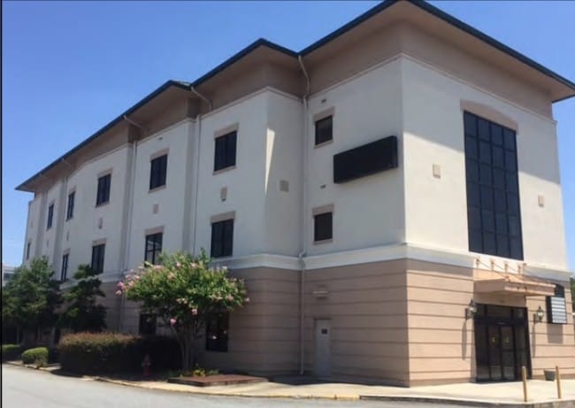


Property Detail
1707 Watson Blvd
0W49AA003000
TRACT 1 ALBERT HUDSON 173/5TH
Medicalbuilding
HOUSTON
C2
Georgia
B and X Area of moderate flood hazard, usually the area between the limits of the 100-year and 500-year floods.
1
2025
0.18 AC
2025
Perry/Warner Robins
020900
Other Market Areas
17,820 SF
Warner Robins, GA
NEARBY LISTINGS FOR SALE OR LEASE
DEMOGRAPHICS near 1707 Watson Blvd
1 mile
3 mile
5 mile
2025 Total Population
8,965
59,209
104,184
2030 Population
9,401
62,365
109,752
Pop Growth 2025-2030
+ 4.86%
+ 5.33%
+ 5.34%
Average Age
38
38
38
2025 Total Households
3,477
23,949
41,106
HH Growth 2025-2030
+ 4.86%
+ 5.38%
+ 5.40%
Median Household Inc
$60,249
$53,237
$65,801
Avg Household Size
2.40
2.40
2.50
2025 Avg HH Vehicles
2.00
2.00
2.00
Median Home Value
$140,401
$142,931
$179,965
Median Year Built
1966
1978
1989
Nearby Places
Map Layers
Map Styles
 Street
 Aerial
Layers
 Traffic
 Biking
Places
Listings with unknown addresses are not visible on the map
- Restaurants
- Banks
- Shops
- Fitness
- Groceries
SALE & LEASE HISTORY
LISTING DATE
SALE/LEASE

Sep 25, 2016
For Lease
Feb 24, 2025
For Lease
Nearby Properties
Address
Land Use
TOTAL SIZE
Lot Size
Zoning
Address
Land Use
TOTAL SIZE
Lot Size
Zoning
37,908 SF
19.79 AC
C2
Address
Land Use
TOTAL SIZE
Lot Size
Zoning
3,960 SF
22.93 AC
R4
Address
Land Use
TOTAL SIZE
Lot Size
Zoning
3,199 SF
41.42 AC
R4
Address
Land Use
TOTAL SIZE
Lot Size
Zoning
88,965 SF
18.72 AC
R2
Address
Land Use
TOTAL SIZE
Lot Size
Zoning
5,640 SF
24 AC
C2
Address
Land Use
TOTAL SIZE
Lot Size
Zoning
26,271 SF
17.43 AC
C2
Address
Land Use
TOTAL SIZE
Lot Size
Zoning
84,544 SF
35.44 AC
R4
Address
Land Use
TOTAL SIZE
Lot Size
Zoning
94,820 SF
18.66 AC
C2
Address
Land Use
TOTAL SIZE
Lot Size
Zoning
223,599 SF
22.40 AC
C2
Address
Land Use
TOTAL SIZE
Lot Size
Zoning
11,658 SF
30.23 AC
R2
Address
Land Use
TOTAL SIZE
Lot Size
Zoning
100,320 SF
26.91 AC
C2
Address
Land Use
TOTAL SIZE
Lot Size
Zoning
218,304 SF
47.18 AC
C2
Address
Land Use
TOTAL SIZE
Lot Size
Zoning
2,080 SF
15.62 AC
R4
Address
Land Use
TOTAL SIZE
Lot Size
Zoning
304,246 SF
23.11 AC
C2
Address
Land Use
TOTAL SIZE
Lot Size
Zoning
132,850 SF
24.05 AC
C2
Address
Land Use
TOTAL SIZE
Lot Size
Zoning
234,239 SF
24.71 AC
C2
Address
Land Use
TOTAL SIZE
Lot Size
Zoning
164,700 SF
19.20 AC
R3
Address
Land Use
TOTAL SIZE
Lot Size
Zoning
178,400 SF
49.03 AC
R2
Address
Land Use
TOTAL SIZE
Lot Size
Zoning
76,751 SF
26.32 AC
R1
Address
Land Use
TOTAL SIZE
Lot Size
Zoning
125,550 SF
9.82 AC
C2
Address
Land Use
TOTAL SIZE
Lot Size
Zoning
2,231 SF
11.48 AC
C2
Address
Land Use
TOTAL SIZE
Lot Size
Zoning
23,440 SF
18.96 AC
C2
Address
Land Use
TOTAL SIZE
Lot Size
Zoning
78,270 SF
3.35 AC
C2
Address
Land Use
TOTAL SIZE
Lot Size
Zoning
108,750 SF
10.85 AC
C2
Address
Land Use
TOTAL SIZE
Lot Size
Zoning
1,531 SF
27.16 AC
R4
Address
Land Use
TOTAL SIZE
Lot Size
Zoning
14,096 SF
14.12 AC
R4
Address
Land Use
TOTAL SIZE
Lot Size
Zoning
22,112 SF
14.70 AC
R4
Address
Land Use
TOTAL SIZE
Lot Size
Zoning
26,928 SF
5.74 AC
R4
Address
Land Use
TOTAL SIZE
Lot Size
Zoning
91,692 SF
5.69 AC
R4
Address
Land Use
TOTAL SIZE
Lot Size
Zoning
40,284 SF
3.74 AC
C3
The World's #1 Commercial Real Estate Marketplace
Connect with us
© 2026 CoStar Group
The information above has been obtained from sources believed reliable. While we do not doubt its accuracy we have not verified it and make no guarantee, warranty or representation about it. It is your responsibility to independently confirm its accuracy and completeness. Any projections, opinions, assumptions, or estimates used are for example only and do not represent the current or future performance of the property. The value of this transaction to you depends on tax and other factors which should be evaluated by your tax, financial, and legal advisors. You and your advisors should conduct a careful, independent investigation of the property to determine to your satisfaction the suitability of the property for your needs.