Property Record
1710 Old Haywood Rd, Asheville, NC 28806
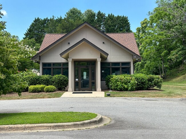
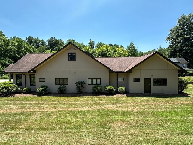
This Property Is For Sale
NEARBY LISTINGS FOR SALE OR LEASE
Property Detail
1710 Old Haywood Rd
Asheville, NC
Boundary & Topographic Survey
9628-22-5145-00000
SUBDIV: BLOCK: LOT: LOT 1 SECTION: PLAT: 0167-0167
Governmentalpublicusegeneral
Buncombe
X
North Carolina
3700962800J
1
0
0.77 AC
2025
West Asheville
001300
Asheville
2,354 SF
DEMOGRAPHICS near 1710 Old Haywood Rd
1 Mile
3 Mile
5 Mile
2024 Total Population
6,729
40,650
86,106
2029 Population
7,018
42,071
89,016
Pop Growth 2024-2029
+ 4.29%
+ 3.50%
+ 3.38%
Average Age
38
40
40
2024 Total Households
2,806
17,258
36,817
HH Growth 2024-2029
+ 3.74%
+ 2.92%
+ 2.98%
Median Household Inc
$52,754
$63,678
$61,298
Avg Household Size
2.30
2.30
2.20
2024 Avg HH Vehicles
2.00
2.00
2.00
Median Home Value
$299,880
$314,333
$329,396
Median Year Built
1980
1982
1982
Nearby Places
Map Layers
Map Styles
 Street
 Aerial
- Restaurants
- Banks
- Shops
- Fitness
- Groceries
PUBLIC TRANSPORTATION
AIRPORT
Asheville Regional
DRIVE
WALK
Distance
Asheville Regional
20 min
13.0 mi
Nearby Properties
Address
Land Use
TOTAL SIZE
Lot Size
Zoning
Address
Land Use
TOTAL SIZE
Lot Size
Zoning
251,071 SF
280.42 AC
INST
Address
Land Use
TOTAL SIZE
Lot Size
Zoning
166,747 SF
2,480.61 AC
CR
Address
Land Use
TOTAL SIZE
Lot Size
Zoning
100,712 SF
24.65 AC
CS
Address
Land Use
TOTAL SIZE
Lot Size
Zoning
98,232 SF
23.24 AC
EMP
Address
Land Use
TOTAL SIZE
Lot Size
Zoning
46,724 SF
2,480.61 AC
CR
Address
Land Use
TOTAL SIZE
Lot Size
Zoning
85,997 SF
29.25 AC
R-3
Address
Land Use
TOTAL SIZE
Lot Size
Zoning
50,672 SF
21.21 AC
R-2
Address
Land Use
TOTAL SIZE
Lot Size
Zoning
88,817 SF
19.63 AC
R-2
Address
Land Use
TOTAL SIZE
Lot Size
Zoning
81,621 SF
19.62 AC
PS
Address
Land Use
TOTAL SIZE
Lot Size
Zoning
97,263 SF
17.50 AC
INST
Address
Land Use
TOTAL SIZE
Lot Size
Zoning
151,884 SF
129.72 AC
PS
Address
Land Use
TOTAL SIZE
Lot Size
Zoning
76,459 SF
7.01 AC
RM8
Address
Land Use
TOTAL SIZE
Lot Size
Zoning
111,000 SF
21.97 AC
PS
Address
Land Use
TOTAL SIZE
Lot Size
Zoning
72,413 SF
18.25 AC
RM16
Address
Land Use
TOTAL SIZE
Lot Size
Zoning
2,171 SF
36.73 AC
PS
Address
Land Use
TOTAL SIZE
Lot Size
Zoning
44,566 SF
7.39 AC
RM8
Address
Land Use
TOTAL SIZE
Lot Size
Zoning
107,268 SF
9.48 AC
RESORT
Address
Land Use
TOTAL SIZE
Lot Size
Zoning
55,153 SF
13.39 AC
RM16
Address
Land Use
TOTAL SIZE
Lot Size
Zoning
126,508 SF
14.90 AC
EMP
Address
Land Use
TOTAL SIZE
Lot Size
Zoning
43,824 SF
13.71 AC
R-3
Address
Land Use
TOTAL SIZE
Lot Size
Zoning
52,316 SF
13.68 AC
INST
Address
Land Use
TOTAL SIZE
Lot Size
Zoning
30,664 SF
3.26 AC
HR-3:CRDR
Address
Land Use
TOTAL SIZE
Lot Size
Zoning
145,519 SF
10.75 AC
R-2
Address
Land Use
TOTAL SIZE
Lot Size
Zoning
131,946 SF
13.28 AC
EMP
Address
Land Use
TOTAL SIZE
Lot Size
Zoning
35,952 SF
9.30 AC
RM16
Address
Land Use
TOTAL SIZE
Lot Size
Zoning
45,670 SF
11.20 AC
RM8
Address
Land Use
TOTAL SIZE
Lot Size
Zoning
145,468 SF
24.91 AC
COM EXP
Address
Land Use
TOTAL SIZE
Lot Size
Zoning
141,577 SF
30.05 AC
Address
Land Use
TOTAL SIZE
Lot Size
Zoning
51,076 SF
6.53 AC
RM16
Address
Land Use
TOTAL SIZE
Lot Size
Zoning
70,824 SF
12 AC
INST
The World's #1 Commercial Real Estate Marketplace
Connect with us
© 2025 CoStar Group
The information above has been obtained from sources believed reliable. While we do not doubt its accuracy we have not verified it and make no guarantee, warranty or representation about it. It is your responsibility to independently confirm its accuracy and completeness. Any projections, opinions, assumptions, or estimates used are for example only and do not represent the current or future performance of the property. The value of this transaction to you depends on tax and other factors which should be evaluated by your tax, financial, and legal advisors. You and your advisors should conduct a careful, independent investigation of the property to determine to your satisfaction the suitability of the property for your needs.