Property Record
1708 E Algonquin Rd, Hoffman Estates, IL 60192
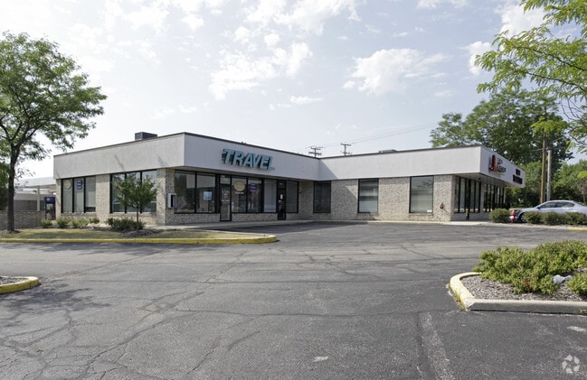


Property Detail
1708 E Algonquin Rd
01-25-203-052-0000
Cook
Commercialbuilding
Illinois
B and X Area of moderate flood hazard, usually the area between the limits of the 100-year and 500-year floods.
0.31 AC
2023
Schaumburg Area
2025
Chicago
804603
Chicago-Naperville-Elgin, IL-IN
6,160 SF
NEARBY LISTINGS FOR SALE OR LEASE
DEMOGRAPHICS near 1708 E Algonquin Rd
1 mile
3 mile
5 mile
2025 Total Population
5,743
44,313
164,846
2030 Population
5,813
44,537
166,110
Pop Growth 2025-2030
+ 1.22%
+ 0.51%
+ 0.77%
Average Age
43
42
42
2025 Total Households
1,911
15,357
62,172
HH Growth 2025-2030
+ 1.05%
+ 0.30%
+ 0.61%
Median Household Inc
$166,457
$130,889
$111,424
Avg Household Size
3.00
2.80
2.60
2025 Avg HH Vehicles
2.00
2.00
2.00
Median Home Value
$442,263
$433,780
$375,810
Median Year Built
1981
1977
1977
Nearby Places
Map Layers
Map Styles
 Street
 Aerial
Transit
 Traffic
 Biking
Places
Listings with unknown addresses are not visible on the map
- Restaurants
- Banks
- Shops
- Fitness
- Groceries
Nearby Properties
Address
Land Use
TOTAL SIZE
Lot Size
Zoning
Address
Land Use
TOTAL SIZE
Lot Size
Zoning
Address
Land Use
TOTAL SIZE
Lot Size
Zoning
Address
Land Use
TOTAL SIZE
Lot Size
Zoning
934,038 SF
45.88 AC
Address
Land Use
TOTAL SIZE
Lot Size
Zoning
1,367,997 SF
Address
Land Use
TOTAL SIZE
Lot Size
Zoning
Address
Land Use
TOTAL SIZE
Lot Size
Zoning
382,200 SF
45.71 AC
Address
Land Use
TOTAL SIZE
Lot Size
Zoning
527,661 SF
27.39 AC
Address
Land Use
TOTAL SIZE
Lot Size
Zoning
175,200 SF
89.08 AC
Address
Land Use
TOTAL SIZE
Lot Size
Zoning
245,525 SF
14.69 AC
Address
Land Use
TOTAL SIZE
Lot Size
Zoning
Address
Land Use
TOTAL SIZE
Lot Size
Zoning
57,293 SF
5.53 AC
Address
Land Use
TOTAL SIZE
Lot Size
Zoning
Address
Land Use
TOTAL SIZE
Lot Size
Zoning
110,940 SF
25.28 AC
Address
Land Use
TOTAL SIZE
Lot Size
Zoning
Address
Land Use
TOTAL SIZE
Lot Size
Zoning
61,623 SF
3.73 AC
Address
Land Use
TOTAL SIZE
Lot Size
Zoning
58,690 SF
10 AC
Address
Land Use
TOTAL SIZE
Lot Size
Zoning
240,352 SF
9.65 AC
Address
Land Use
TOTAL SIZE
Lot Size
Zoning
100,527 SF
3.22 AC
Address
Land Use
TOTAL SIZE
Lot Size
Zoning
107,982 SF
8.12 AC
Address
Land Use
TOTAL SIZE
Lot Size
Zoning
29,250 SF
2.57 AC
Address
Land Use
TOTAL SIZE
Lot Size
Zoning
272,944 SF
4.74 AC
Address
Land Use
TOTAL SIZE
Lot Size
Zoning
61,064 SF
5.21 AC
Address
Land Use
TOTAL SIZE
Lot Size
Zoning
161,280 SF
5.50 AC
Address
Land Use
TOTAL SIZE
Lot Size
Zoning
65,469 SF
8.39 AC
Address
Land Use
TOTAL SIZE
Lot Size
Zoning
100,181 SF
Address
Land Use
TOTAL SIZE
Lot Size
Zoning
108,115 SF
3.74 AC
Address
Land Use
TOTAL SIZE
Lot Size
Zoning
172,865 SF
7.41 AC
Address
Land Use
TOTAL SIZE
Lot Size
Zoning
157,124 SF
10.45 AC
Address
Land Use
TOTAL SIZE
Lot Size
Zoning
190,099 SF
24.23 AC
Address
Land Use
TOTAL SIZE
Lot Size
Zoning
72,619 SF
4.04 AC
The World's #1 Commercial Real Estate Marketplace
Connect with us
© 2026 CoStar Group
The information above has been obtained from sources believed reliable. While we do not doubt its accuracy we have not verified it and make no guarantee, warranty or representation about it. It is your responsibility to independently confirm its accuracy and completeness. Any projections, opinions, assumptions, or estimates used are for example only and do not represent the current or future performance of the property. The value of this transaction to you depends on tax and other factors which should be evaluated by your tax, financial, and legal advisors. You and your advisors should conduct a careful, independent investigation of the property to determine to your satisfaction the suitability of the property for your needs.