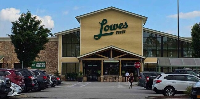
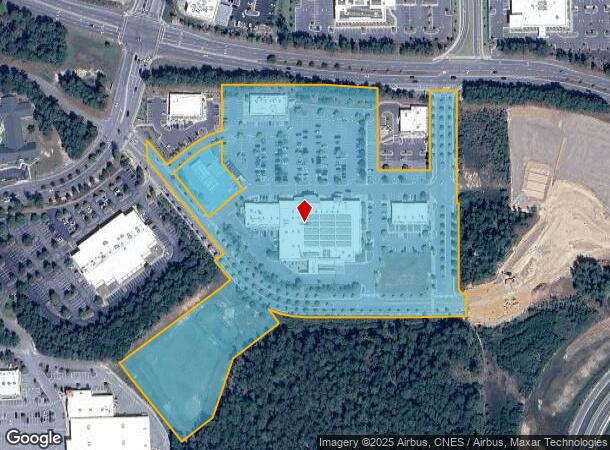
Property Record
1740 Old Morganton Rd, Southern Pines, NC 28387
Current Lease Availabilities
NEARBY LISTINGS FOR SALE OR LEASE
Property Detail
1740 Old Morganton Rd
Pinehurst-Southern Pines, NC
LOT 5
8571-00-48-9331
Moore
Commercialnec
North Carolina
X
5
3710857100J
3.98 AC
2024
North Carolina Southeast Area
2024
Other Market Areas
9508011001
DEMOGRAPHICS near 1740 Old Morganton Rd
1 Mile
3 Mile
5 Mile
2024 Total Population
4,439
27,821
54,396
2029 Population
5,162
31,982
62,392
Pop Growth 2024-2029
+ 16.29%
+ 14.96%
+ 14.70%
Average Age
40
45
45
2024 Total Households
1,970
13,058
24,414
HH Growth 2024-2029
+ 16.55%
+ 15.21%
+ 14.94%
Median Household Inc
$47,999
$72,067
$72,266
Avg Household Size
2.10
2.10
2.20
2024 Avg HH Vehicles
1.00
2.00
2.00
Median Home Value
$368,749
$383,212
$355,644
Median Year Built
1996
1995
1995
Nearby Places
- Restaurants
- Banks
- Shops
- Fitness
- Groceries
PUBLIC TRANSPORTATION
COMMUTER RAIL
Southern Pines Amtrak Station (Silver Star - Amtrak)
DRIVE
WALK
Distance
Southern Pines Amtrak Station (Silver Star - Amtrak)
5 min
2.1 mi
Freight Ports
Port of Wilmington
DRIVE
WALK
Distance
Port of Wilmington
170 min
134.3 mi
Nearby Properties
Address
Land Use
TOTAL SIZE
Lot Size
Zoning
Address
Land Use
TOTAL SIZE
Lot Size
Zoning
20,091 SF
12 AC
PPC
Address
Land Use
TOTAL SIZE
Lot Size
Zoning
18.49 AC
Address
Land Use
TOTAL SIZE
Lot Size
Zoning
16.26 AC
PD
Address
Land Use
TOTAL SIZE
Lot Size
Zoning
7,161 SF
0.87 AC
RD
Address
Land Use
TOTAL SIZE
Lot Size
Zoning
7,024 SF
9.05 AC
Address
Land Use
TOTAL SIZE
Lot Size
Zoning
26.75 AC
Address
Land Use
TOTAL SIZE
Lot Size
Zoning
Address
Land Use
TOTAL SIZE
Lot Size
Zoning
21,138 SF
473.33 AC
RD
Address
Land Use
TOTAL SIZE
Lot Size
Zoning
70,130 SF
19.18 AC
Address
Land Use
TOTAL SIZE
Lot Size
Zoning
22,772 SF
12.46 AC
HC
Address
Land Use
TOTAL SIZE
Lot Size
Zoning
51,552 SF
33.02 AC
GBCD
Address
Land Use
TOTAL SIZE
Lot Size
Zoning
4,184 SF
13.85 AC
R6
Address
Land Use
TOTAL SIZE
Lot Size
Zoning
83,896 SF
66.98 AC
R20
Address
Land Use
TOTAL SIZE
Lot Size
Zoning
44.59 AC
MULTI
Address
Land Use
TOTAL SIZE
Lot Size
Zoning
4,992 SF
14.75 AC
PD
Address
Land Use
TOTAL SIZE
Lot Size
Zoning
12.78 AC
Address
Land Use
TOTAL SIZE
Lot Size
Zoning
39,490 SF
5.16 AC
GBCD
Address
Land Use
TOTAL SIZE
Lot Size
Zoning
4,710 SF
6.95 AC
R6
Address
Land Use
TOTAL SIZE
Lot Size
Zoning
190.53 AC
Address
Land Use
TOTAL SIZE
Lot Size
Zoning
Address
Land Use
TOTAL SIZE
Lot Size
Zoning
155.66 AC
RD
Address
Land Use
TOTAL SIZE
Lot Size
Zoning
199,100 SF
24.89 AC
HC
Address
Land Use
TOTAL SIZE
Lot Size
Zoning
8.15 AC
GC
Address
Land Use
TOTAL SIZE
Lot Size
Zoning
Address
Land Use
TOTAL SIZE
Lot Size
Zoning
7.62 AC
Address
Land Use
TOTAL SIZE
Lot Size
Zoning
33,296 SF
11.23 AC
HC
Address
Land Use
TOTAL SIZE
Lot Size
Zoning
2,450 SF
2.96 AC
Address
Land Use
TOTAL SIZE
Lot Size
Zoning
57,109 SF
4.08 AC
GBSD
Address
Land Use
TOTAL SIZE
Lot Size
Zoning
0.84 AC
GC
The World's #1 Commercial Real Estate Marketplace
Connect with us
© 2025 CoStar Group
The information above has been obtained from sources believed reliable. While we do not doubt its accuracy we have not verified it and make no guarantee, warranty or representation about it. It is your responsibility to independently confirm its accuracy and completeness. Any projections, opinions, assumptions, or estimates used are for example only and do not represent the current or future performance of the property. The value of this transaction to you depends on tax and other factors which should be evaluated by your tax, financial, and legal advisors. You and your advisors should conduct a careful, independent investigation of the property to determine to your satisfaction the suitability of the property for your needs.