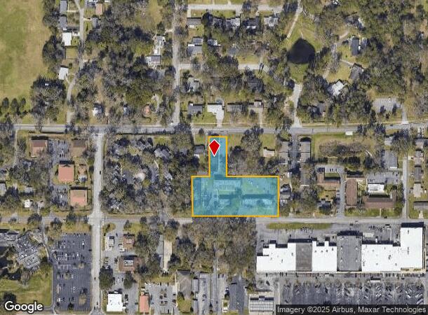
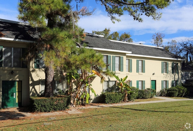
Property Record
1709 Ne 2Nd St, Ocala, FL 34470


NEARBY LISTINGS FOR SALE OR LEASE
Property Detail
1709 Ne 2Nd St
Ocala, FL
6 7 9 11 Subdivision Of 20 Orange View
28337-020-03
SEC 16 TWP 15 RGE 22 PLAT BOOK B PAGE 239 ORANGE VIEW LOTS 3.5.6.7.9.11 SUB OF LOT 20 BRIARWOOD APTS
Apartment
Marion
X
Florida
12083C0528E
3,20
2025
2.30 AC
2025
Northeast Ocala
002001
Ocala
45,736 SF
DEMOGRAPHICS near 1709 Ne 2Nd St
1 mile
3 mile
5 mile
2024 Total Population
7,921
51,871
101,930
2029 Population
8,905
58,338
114,932
Pop Growth 2024-2029
+ 12.42%
+ 12.47%
+ 12.76%
Average Age
38
41
41
2024 Total Households
3,347
21,528
41,151
HH Growth 2024-2029
+ 12.46%
+ 12.44%
+ 12.80%
Median Household Inc
$46,117
$50,649
$54,140
Avg Household Size
2.30
2.30
2.40
2024 Avg HH Vehicles
2.00
2.00
2.00
Median Home Value
$204,272
$179,583
$190,210
Median Year Built
1967
1978
1983
Nearby Places
Map Layers
Map Styles
 Street
 Aerial
Transit
 Traffic
 Biking
Places
Listings with unknown addresses are not visible on the map
- Restaurants
- Banks
- Shops
- Fitness
- Groceries
SALE & LEASE HISTORY
LISTING DATE
SALE/LEASE

Nov 03, 2016
For Sale
Nearby Properties
Address
Land Use
TOTAL SIZE
Lot Size
Zoning
Address
Land Use
TOTAL SIZE
Lot Size
Zoning
207,950 SF
14.08 AC
INST
Address
Land Use
TOTAL SIZE
Lot Size
Zoning
331,687 SF
11.66 AC
INST
Address
Land Use
TOTAL SIZE
Lot Size
Zoning
189,025 SF
35.42 AC
PD08
Address
Land Use
TOTAL SIZE
Lot Size
Zoning
195,992 SF
5.72 AC
FBC
Address
Land Use
TOTAL SIZE
Lot Size
Zoning
17,071 SF
69.56 AC
MH
Address
Land Use
TOTAL SIZE
Lot Size
Zoning
88,462 SF
31.76 AC
INST
Address
Land Use
TOTAL SIZE
Lot Size
Zoning
89,719 SF
15.16 AC
PD12
Address
Land Use
TOTAL SIZE
Lot Size
Zoning
76,062 SF
23.73 AC
B4
Address
Land Use
TOTAL SIZE
Lot Size
Zoning
30,274 SF
3.94 AC
FBC
Address
Land Use
TOTAL SIZE
Lot Size
Zoning
116,035 SF
38.20 AC
GU
Address
Land Use
TOTAL SIZE
Lot Size
Zoning
56,484 SF
12.50 AC
PD14
Address
Land Use
TOTAL SIZE
Lot Size
Zoning
111,395 SF
13 AC
B2
Address
Land Use
TOTAL SIZE
Lot Size
Zoning
180,334 SF
24.29 AC
INST
Address
Land Use
TOTAL SIZE
Lot Size
Zoning
101,892 SF
16.81 AC
INST
Address
Land Use
TOTAL SIZE
Lot Size
Zoning
95,552 SF
11.31 AC
SC
Address
Land Use
TOTAL SIZE
Lot Size
Zoning
5,815 SF
186.33 AC
GU
Address
Land Use
TOTAL SIZE
Lot Size
Zoning
30,334 SF
34.53 AC
GU
Address
Land Use
TOTAL SIZE
Lot Size
Zoning
46,293 SF
11.30 AC
GU
Address
Land Use
TOTAL SIZE
Lot Size
Zoning
78,280 SF
12.54 AC
R3
Address
Land Use
TOTAL SIZE
Lot Size
Zoning
112,663 SF
32.72 AC
INST
Address
Land Use
TOTAL SIZE
Lot Size
Zoning
19,117 SF
0.98 AC
FBC
Address
Land Use
TOTAL SIZE
Lot Size
Zoning
71,065 SF
12.01 AC
B2
Address
Land Use
TOTAL SIZE
Lot Size
Zoning
134,827 SF
14.83 AC
SC
Address
Land Use
TOTAL SIZE
Lot Size
Zoning
95,964 SF
15.51 AC
M1
Address
Land Use
TOTAL SIZE
Lot Size
Zoning
49,963 SF
9.84 AC
PD14
Address
Land Use
TOTAL SIZE
Lot Size
Zoning
26,801 SF
5.66 AC
FBC
Address
Land Use
TOTAL SIZE
Lot Size
Zoning
132,244 SF
11.60 AC
SC
Address
Land Use
TOTAL SIZE
Lot Size
Zoning
107,993 SF
66.76 AC
GU
Address
Land Use
TOTAL SIZE
Lot Size
Zoning
121,462 SF
10.92 AC
B2
Address
Land Use
TOTAL SIZE
Lot Size
Zoning
41,519 SF
4.84 AC
B4
The World's #1 Commercial Real Estate Marketplace
Connect with us
© 2026 CoStar Group
The information above has been obtained from sources believed reliable. While we do not doubt its accuracy we have not verified it and make no guarantee, warranty or representation about it. It is your responsibility to independently confirm its accuracy and completeness. Any projections, opinions, assumptions, or estimates used are for example only and do not represent the current or future performance of the property. The value of this transaction to you depends on tax and other factors which should be evaluated by your tax, financial, and legal advisors. You and your advisors should conduct a careful, independent investigation of the property to determine to your satisfaction the suitability of the property for your needs.