Property Record
171 Bancroft Rd, Kennett Square, PA 19348
NEARBY LISTINGS FOR SALE OR LEASE
-
-
View all Kennett Square listings for sale on LoopNet.com
Property Detail
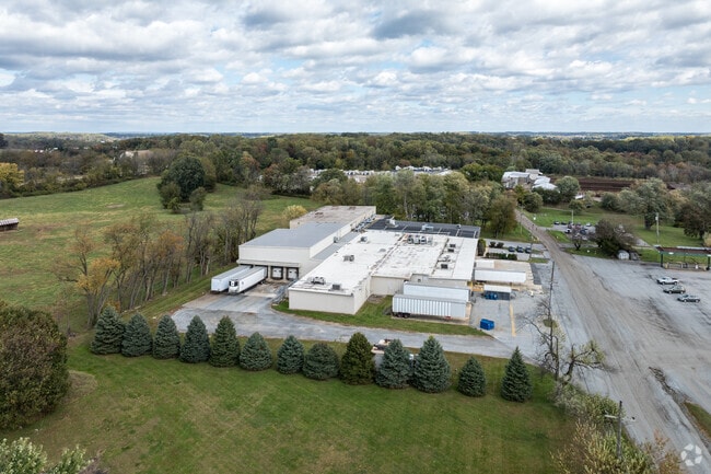
171 Bancroft Rd
Philadelphia-Camden-Wilmington, PA-NJ-DE-MD
Modern Mushroom Farms Inc
60-001-0052.0300
94.7 AC MUSH PLANT & MH
Residentialacreage
Chester
X
Pennsylvania
42029C0290G
4.10 AC
2024
Chester
2025
Philadelphia
306503
DEMOGRAPHICS near 171 Bancroft Rd
1 Mile
3 Mile
5 Mile
2024 Total Population
1,320
19,989
47,817
2029 Population
1,395
20,805
49,701
Pop Growth 2024-2029
+ 5.68%
+ 4.08%
+ 3.94%
Average Age
37
38
40
2024 Total Households
414
6,638
16,449
HH Growth 2024-2029
+ 6.28%
+ 4.34%
+ 4.13%
Median Household Inc
$77,430
$102,371
$121,378
Avg Household Size
3.00
2.90
2.80
2024 Avg HH Vehicles
2.00
2.00
2.00
Median Home Value
$397,548
$407,910
$438,467
Median Year Built
1994
1983
1990
Nearby Places
Map Layers
Map Styles
 Street
 Aerial
- Restaurants
- Banks
- Shops
- Fitness
- Groceries
PUBLIC TRANSPORTATION
AIRPORT
Philadelphia International
DRIVE
WALK
Distance
Philadelphia International
52 min
30.4 mi
Freight Ports
Port of Wilmington, RI
DRIVE
WALK
Distance
Port of Wilmington, RI
37 min
19.9 mi
Nearby Properties
Address
Land Use
TOTAL SIZE
Lot Size
Zoning
Address
Land Use
TOTAL SIZE
Lot Size
Zoning
258,320 SF
42.68 AC
CI
Address
Land Use
TOTAL SIZE
Lot Size
Zoning
215,130 SF
11.80 AC
R2
Address
Land Use
TOTAL SIZE
Lot Size
Zoning
238,215 SF
35.70 AC
R3
Address
Land Use
TOTAL SIZE
Lot Size
Zoning
105,405 SF
17 AC
R1
Address
Land Use
TOTAL SIZE
Lot Size
Zoning
121,326 SF
14.98 AC
R2
Address
Land Use
TOTAL SIZE
Lot Size
Zoning
121,326 SF
14.98 AC
R2
Address
Land Use
TOTAL SIZE
Lot Size
Zoning
152,629 SF
152.30 AC
ES1
Address
Land Use
TOTAL SIZE
Lot Size
Zoning
99,228 SF
0.57 AC
C2
Address
Land Use
TOTAL SIZE
Lot Size
Zoning
67,011 SF
6.78 AC
R2A
Address
Land Use
TOTAL SIZE
Lot Size
Zoning
451,182 SF
94.70 AC
BP
Address
Land Use
TOTAL SIZE
Lot Size
Zoning
114,126 SF
18.10 AC
CI
Address
Land Use
TOTAL SIZE
Lot Size
Zoning
69,351 SF
25 AC
UD
Address
Land Use
TOTAL SIZE
Lot Size
Zoning
200,337 SF
14 AC
CI
Address
Land Use
TOTAL SIZE
Lot Size
Zoning
64,946 SF
0.18 AC
C1
Address
Land Use
TOTAL SIZE
Lot Size
Zoning
70,197 SF
64.54 AC
ES1
Address
Land Use
TOTAL SIZE
Lot Size
Zoning
87,680 SF
11.40 AC
CI
Address
Land Use
TOTAL SIZE
Lot Size
Zoning
65,310 SF
5.07 AC
RB
Address
Land Use
TOTAL SIZE
Lot Size
Zoning
106,200 SF
10.40 AC
CI
Address
Land Use
TOTAL SIZE
Lot Size
Zoning
175,250 SF
50 AC
SA
Address
Land Use
TOTAL SIZE
Lot Size
Zoning
106,210 SF
11.70 AC
UD
Address
Land Use
TOTAL SIZE
Lot Size
Zoning
54,097 SF
3.80 AC
R3
Address
Land Use
TOTAL SIZE
Lot Size
Zoning
70,448 SF
11.40 AC
CI
Address
Land Use
TOTAL SIZE
Lot Size
Zoning
128,868 SF
1.25 AC
C2
Address
Land Use
TOTAL SIZE
Lot Size
Zoning
33,620 SF
1.13 AC
R2A
Address
Land Use
TOTAL SIZE
Lot Size
Zoning
32,596 SF
1.15 AC
C3
Address
Land Use
TOTAL SIZE
Lot Size
Zoning
2,976 SF
3.28 AC
R2
Address
Land Use
TOTAL SIZE
Lot Size
Zoning
66,184 SF
16 AC
ES1
Address
Land Use
TOTAL SIZE
Lot Size
Zoning
32,576 SF
9.30 AC
CI
Address
Land Use
TOTAL SIZE
Lot Size
Zoning
104,344 SF
9.20 AC
UD
Address
Land Use
TOTAL SIZE
Lot Size
Zoning
71,830 SF
22.40 AC
R2
The World's #1 Commercial Real Estate Marketplace
Connect with us
© 2026 CoStar Group
The information above has been obtained from sources believed reliable. While we do not doubt its accuracy we have not verified it and make no guarantee, warranty or representation about it. It is your responsibility to independently confirm its accuracy and completeness. Any projections, opinions, assumptions, or estimates used are for example only and do not represent the current or future performance of the property. The value of this transaction to you depends on tax and other factors which should be evaluated by your tax, financial, and legal advisors. You and your advisors should conduct a careful, independent investigation of the property to determine to your satisfaction the suitability of the property for your needs.