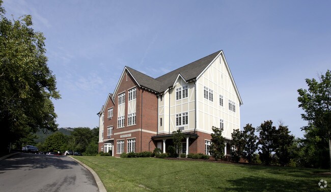
Property Record
171 Baylor School Rd, Chattanooga, TN 37405


NEARBY LISTINGS FOR SALE OR LEASE
-
-
View all Chattanooga listings for sale on LoopNet.com
Property Detail
171 Baylor School Rd
126-004
BAYLOR SCHOOL RD
Publicschool
Hamilton
AE
Tennessee
47065C0329G
40 AC
0
Outlying Hamilton County
2025
Chattanooga
010901
Chattanooga, TN-GA
DEMOGRAPHICS near 171 Baylor School Rd
1 Mile
3 Mile
5 Mile
2024 Total Population
1,991
35,376
82,309
2029 Population
2,126
38,111
88,760
Pop Growth 2024-2029
+ 6.78%
+ 7.73%
+ 7.84%
Average Age
39
40
39
2024 Total Households
946
17,438
37,467
HH Growth 2024-2029
+ 7.19%
+ 8.25%
+ 8.28%
Median Household Inc
$62,173
$65,012
$59,884
Avg Household Size
1.90
2.00
2.10
2024 Avg HH Vehicles
2.00
2.00
2.00
Median Home Value
$273,809
$335,764
$289,924
Median Year Built
1988
1978
1976
Nearby Places
Map Layers
Map Styles
 Street
 Aerial
- Restaurants
- Banks
- Shops
- Fitness
- Groceries
PUBLIC TRANSPORTATION
AIRPORT
Lovell Field
DRIVE
WALK
Distance
Lovell Field
27 min
14.0 mi
Freight Ports
Georgia Ports - Savannah
DRIVE
WALK
Distance
Georgia Ports - Savannah
417 min
369.2 mi
Nearby Properties
Address
Land Use
TOTAL SIZE
Lot Size
Zoning
Address
Land Use
TOTAL SIZE
Lot Size
Zoning
1,750,017 SF
31.32 AC
Address
Land Use
TOTAL SIZE
Lot Size
Zoning
603,035 SF
21.57 AC
C3
Address
Land Use
TOTAL SIZE
Lot Size
Zoning
6.35 AC
Address
Land Use
TOTAL SIZE
Lot Size
Zoning
409,451 SF
2.53 AC
C3
Address
Land Use
TOTAL SIZE
Lot Size
Zoning
19.38 AC
M1
Address
Land Use
TOTAL SIZE
Lot Size
Zoning
105,125 SF
3.38 AC
Address
Land Use
TOTAL SIZE
Lot Size
Zoning
275,364 SF
16.86 AC
C2
Address
Land Use
TOTAL SIZE
Lot Size
Zoning
293,516 SF
5.12 AC
M1
Address
Land Use
TOTAL SIZE
Lot Size
Zoning
171,906 SF
2.10 AC
C2
Address
Land Use
TOTAL SIZE
Lot Size
Zoning
75,697 SF
1.33 AC
Address
Land Use
TOTAL SIZE
Lot Size
Zoning
89,880 SF
15 AC
R1
Address
Land Use
TOTAL SIZE
Lot Size
Zoning
432,056 SF
2.54 AC
C3
Address
Land Use
TOTAL SIZE
Lot Size
Zoning
203,554 SF
56.70 AC
Address
Land Use
TOTAL SIZE
Lot Size
Zoning
5,460 SF
43.30 AC
R1
Address
Land Use
TOTAL SIZE
Lot Size
Zoning
157,069 SF
0.99 AC
C3
Address
Land Use
TOTAL SIZE
Lot Size
Zoning
145,288 SF
2.36 AC
Address
Land Use
TOTAL SIZE
Lot Size
Zoning
134,901 SF
1.06 AC
C3
Address
Land Use
TOTAL SIZE
Lot Size
Zoning
150,640 SF
17.78 AC
R1
Address
Land Use
TOTAL SIZE
Lot Size
Zoning
4.70 AC
9999
Address
Land Use
TOTAL SIZE
Lot Size
Zoning
89,340 SF
6.95 AC
Address
Land Use
TOTAL SIZE
Lot Size
Zoning
189,456 SF
11.18 AC
C3
Address
Land Use
TOTAL SIZE
Lot Size
Zoning
95,584 SF
4.60 AC
A1
Address
Land Use
TOTAL SIZE
Lot Size
Zoning
121,950 SF
5.09 AC
Address
Land Use
TOTAL SIZE
Lot Size
Zoning
247,800 SF
1.19 AC
C3
Address
Land Use
TOTAL SIZE
Lot Size
Zoning
38,267 SF
3.07 AC
M1
Address
Land Use
TOTAL SIZE
Lot Size
Zoning
13,820 SF
12 AC
R3
Address
Land Use
TOTAL SIZE
Lot Size
Zoning
31,131 SF
46.17 AC
R1
Address
Land Use
TOTAL SIZE
Lot Size
Zoning
127,369 SF
0.79 AC
M1
Address
Land Use
TOTAL SIZE
Lot Size
Zoning
243,264 SF
0.52 AC
C3
Address
Land Use
TOTAL SIZE
Lot Size
Zoning
144,416 SF
1.62 AC
C3
The World's #1 Commercial Real Estate Marketplace
Connect with us
© 2026 CoStar Group
The information above has been obtained from sources believed reliable. While we do not doubt its accuracy we have not verified it and make no guarantee, warranty or representation about it. It is your responsibility to independently confirm its accuracy and completeness. Any projections, opinions, assumptions, or estimates used are for example only and do not represent the current or future performance of the property. The value of this transaction to you depends on tax and other factors which should be evaluated by your tax, financial, and legal advisors. You and your advisors should conduct a careful, independent investigation of the property to determine to your satisfaction the suitability of the property for your needs.