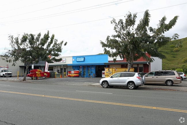
Property Record
171 Hamakua Dr, Kailua, HI 96734
Current Lease Availabilities
NEARBY LISTINGS FOR SALE OR LEASE
Property Detail
171 Hamakua Dr
Urban Honolulu, HI
Wyco Industrial Park
1-4-2-038-057-0000
LOT 12 WYCO INDUSTRIAL PARK FP 1223 9530 SF
Industrialgeneral
Honolulu
AE
Hawaii
15003C0290H
12
2024
0.22 AC
2025
Windward
011105
Hawaii
9,694 SF
DEMOGRAPHICS near 171 Hamakua Dr
1 Mile
3 Mile
5 Mile
2024 Total Population
17,150
46,448
95,966
2029 Population
16,713
44,689
92,638
Pop Growth 2024-2029
(2.55%)
(3.79%)
(3.47%)
Average Age
42
43
40
2024 Total Households
5,987
15,351
28,957
HH Growth 2024-2029
(3.37%)
(4.77%)
(4.37%)
Median Household Inc
$124,250
$138,906
$119,544
Avg Household Size
2.70
2.80
3.00
2024 Avg HH Vehicles
2.00
2.00
2.00
Median Home Value
$1,021,029
$1,060,101
$957,043
Median Year Built
1967
1966
1970
Nearby Places
- Restaurants
- Banks
- Shops
- Fitness
- Groceries
PUBLIC TRANSPORTATION
AIRPORT
Daniel K Inouye International
DRIVE
WALK
Distance
Daniel K Inouye International
31 min
16.3 mi
Freight Ports
Honolulu Harbor, Oahu
DRIVE
WALK
Distance
Honolulu Harbor, Oahu
33 min
15.4 mi
Nearby Properties
Address
Land Use
TOTAL SIZE
Lot Size
Zoning
Address
Land Use
TOTAL SIZE
Lot Size
Zoning
130,311 SF
7.05 AC
B-2
Address
Land Use
TOTAL SIZE
Lot Size
Zoning
325,894 SF
22.26 AC
I-2
Address
Land Use
TOTAL SIZE
Lot Size
Zoning
226,160 SF
9.90 AC
R-5
Address
Land Use
TOTAL SIZE
Lot Size
Zoning
137,288 SF
16.12 AC
A-2
Address
Land Use
TOTAL SIZE
Lot Size
Zoning
56.87 AC
I-1
Address
Land Use
TOTAL SIZE
Lot Size
Zoning
75,635 SF
7.21 AC
B-1
Address
Land Use
TOTAL SIZE
Lot Size
Zoning
54,244 SF
3.38 AC
B-2
Address
Land Use
TOTAL SIZE
Lot Size
Zoning
120,970 SF
2.43 AC
B-2
Address
Land Use
TOTAL SIZE
Lot Size
Zoning
55,645 SF
3.10 AC
B-2
Address
Land Use
TOTAL SIZE
Lot Size
Zoning
397,566 SF
3.09 AC
B-1
Address
Land Use
TOTAL SIZE
Lot Size
Zoning
70,952 SF
2.31 AC
B-2
Address
Land Use
TOTAL SIZE
Lot Size
Zoning
44,774 SF
2.74 AC
B-1
Address
Land Use
TOTAL SIZE
Lot Size
Zoning
48,556 SF
2.18 AC
B-2
Address
Land Use
TOTAL SIZE
Lot Size
Zoning
39,898 SF
163.13 AC
P-2
Address
Land Use
TOTAL SIZE
Lot Size
Zoning
32,742 SF
2.69 AC
B-1
Address
Land Use
TOTAL SIZE
Lot Size
Zoning
5,952 SF
1.73 AC
B-2
Address
Land Use
TOTAL SIZE
Lot Size
Zoning
1.76 AC
BMX-3
Address
Land Use
TOTAL SIZE
Lot Size
Zoning
69,142 SF
132.46 AC
P-1
Address
Land Use
TOTAL SIZE
Lot Size
Zoning
24,971 SF
1.67 AC
B-2
Address
Land Use
TOTAL SIZE
Lot Size
Zoning
1.74 AC
BMX-3
Address
Land Use
TOTAL SIZE
Lot Size
Zoning
21,111 SF
1.95 AC
B-1
Address
Land Use
TOTAL SIZE
Lot Size
Zoning
123,725 SF
572.87 AC
P-1
Address
Land Use
TOTAL SIZE
Lot Size
Zoning
55,365 SF
0.83 AC
B-2
Address
Land Use
TOTAL SIZE
Lot Size
Zoning
52,112 SF
0.68 AC
R-5
Address
Land Use
TOTAL SIZE
Lot Size
Zoning
13,474 SF
1.24 AC
B-2
Address
Land Use
TOTAL SIZE
Lot Size
Zoning
27,078 SF
1.19 AC
B-2
Address
Land Use
TOTAL SIZE
Lot Size
Zoning
41,314 SF
0.59 AC
B-2
Address
Land Use
TOTAL SIZE
Lot Size
Zoning
413.01 AC
AG-2
Address
Land Use
TOTAL SIZE
Lot Size
Zoning
25,540 SF
1.03 AC
B-2
Address
Land Use
TOTAL SIZE
Lot Size
Zoning
32,816 SF
0.87 AC
B-2
The World's #1 Commercial Real Estate Marketplace
Connect with us
© 2025 CoStar Group
The information above has been obtained from sources believed reliable. While we do not doubt its accuracy we have not verified it and make no guarantee, warranty or representation about it. It is your responsibility to independently confirm its accuracy and completeness. Any projections, opinions, assumptions, or estimates used are for example only and do not represent the current or future performance of the property. The value of this transaction to you depends on tax and other factors which should be evaluated by your tax, financial, and legal advisors. You and your advisors should conduct a careful, independent investigation of the property to determine to your satisfaction the suitability of the property for your needs.