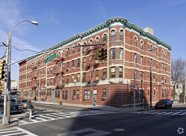
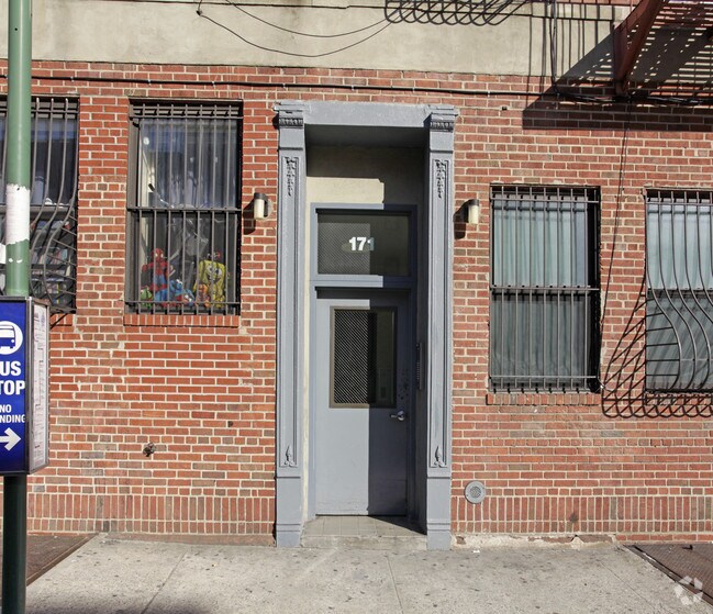
Property Record
171 Rockaway Ave, Brooklyn, NY 11233
NEARBY LISTINGS FOR SALE OR LEASE
Property Detail
171 Rockaway Ave
01568-0001
Kings
Multifamilydwelling
New York
X
1
3604970216F
0.32 AC
2024
Ocean Hill
2025
Long Island (New York)
030100
New York-Jersey City-White Plains, NY-NJ
37,600 SF
DEMOGRAPHICS near 171 Rockaway Ave
1 Mile
3 Mile
5 Mile
2024 Total Population
138,214
1,112,399
2,541,036
2029 Population
129,139
1,036,787
2,381,498
Pop Growth 2024-2029
(6.57%)
(6.80%)
(6.28%)
Average Age
37
38
39
2024 Total Households
49,241
402,404
951,511
HH Growth 2024-2029
(7.17%)
(7.20%)
(6.53%)
Median Household Inc
$42,332
$60,135
$72,996
Avg Household Size
2.60
2.60
2.60
2024 Avg HH Vehicles
.00
.00
1.00
Median Home Value
$772,699
$755,800
$773,798
Median Year Built
1948
1948
1949
Nearby Places
- Restaurants
- Banks
- Shops
- Fitness
- Groceries
PUBLIC TRANSPORTATION
TRANSIT/SUBWAY
Rockaway Avenue (A,C Line) (A - New York MTA Subway (The Subway), C - New York MTA Subway (The Subway))
DRIVE
WALK
Distance
Rockaway Avenue (A,C Line) (A - New York MTA Subway (The Subway), C - New York MTA Subway (The Subway))
0 min
3 min
0.2 mi
Broadway Junction (8 Avenue Express - MTA New York City Transit, 8 Avenue Local - MTA New York City Transit, Nassau St Express - MTA New York City Transit, Nassau St Local - MTA New York City Transit)
DRIVE
WALK
Distance
Broadway Junction (8 Avenue Express - MTA New York City Transit, 8 Avenue Local - MTA New York City Transit, Nassau St Express - MTA New York City Transit, Nassau St Local - MTA New York City Transit)
1 min
7 min
0.4 mi
Atlantic Avenue (L Line) (L - New York MTA Subway (The Subway))
DRIVE
WALK
Distance
Atlantic Avenue (L Line) (L - New York MTA Subway (The Subway))
1 min
9 min
0.5 mi
Chauncey Street (J - New York MTA Subway (The Subway), Z - New York MTA Subway (The Subway))
DRIVE
WALK
Distance
Chauncey Street (J - New York MTA Subway (The Subway), Z - New York MTA Subway (The Subway))
1 min
10 min
0.5 mi
Broadway Junction (East New York) (A - New York MTA Subway (The Subway), C - New York MTA Subway (The Subway), J - New York MTA Subway (The Subway), L - New York MTA Subway (The Subway), Z - New York MTA Subway (The Subway))
DRIVE
WALK
Distance
Broadway Junction (East New York) (A - New York MTA Subway (The Subway), C - New York MTA Subway (The Subway), J - New York MTA Subway (The Subway), L - New York MTA Subway (The Subway), Z - New York MTA Subway (The Subway))
2 min
10 min
0.6 mi
COMMUTER RAIL
East New York Station (Far Rockaway Branch - Long Island Rail Road, Long Beach Branch - Long Island Rail Road, West Hempstead Branch - Long Island Rail Road)
DRIVE
WALK
Distance
East New York Station (Far Rockaway Branch - Long Island Rail Road, Long Beach Branch - Long Island Rail Road, West Hempstead Branch - Long Island Rail Road)
1 min
8 min
0.4 mi
Nostrand Avenue Station (Far Rockaway Branch - Long Island Rail Road, Hempstead Branch - Long Island Rail Road, Long Beach Branch - Long Island Rail Road, West Hempstead Branch - Long Island Rail Road)
DRIVE
WALK
Distance
Nostrand Avenue Station (Far Rockaway Branch - Long Island Rail Road, Hempstead Branch - Long Island Rail Road, Long Beach Branch - Long Island Rail Road, West Hempstead Branch - Long Island Rail Road)
7 min
2.4 mi
AIRPORT
LaGuardia
DRIVE
WALK
Distance
LaGuardia
19 min
8.6 mi
John F Kennedy International
DRIVE
WALK
Distance
John F Kennedy International
16 min
8.8 mi
Newark Liberty International
DRIVE
WALK
Distance
Newark Liberty International
34 min
18.0 mi
Freight Ports
NY - Red Hook Container Terminal
DRIVE
WALK
Distance
NY - Red Hook Container Terminal
16 min
7.0 mi
Nearby Properties
Address
Land Use
TOTAL SIZE
Lot Size
Zoning
Address
Land Use
TOTAL SIZE
Lot Size
Zoning
1,503,150 SF
20.47 AC
R5
Address
Land Use
TOTAL SIZE
Lot Size
Zoning
835,231 SF
11.32 AC
R6
Address
Land Use
TOTAL SIZE
Lot Size
Zoning
1,061,228 SF
8.86 AC
R5
Address
Land Use
TOTAL SIZE
Lot Size
Zoning
5,302 SF
366.15 AC
PARK
Address
Land Use
TOTAL SIZE
Lot Size
Zoning
561,945 SF
11.58 AC
R6
Address
Land Use
TOTAL SIZE
Lot Size
Zoning
1,688,760 SF
24.65 AC
R5
Address
Land Use
TOTAL SIZE
Lot Size
Zoning
296,915 SF
0.31 AC
C5-3
Address
Land Use
TOTAL SIZE
Lot Size
Zoning
566,000 SF
12.33 AC
R6
Address
Land Use
TOTAL SIZE
Lot Size
Zoning
600 SF
33.07 AC
PARK
Address
Land Use
TOTAL SIZE
Lot Size
Zoning
24,400 SF
33.98 AC
C4-2
Address
Land Use
TOTAL SIZE
Lot Size
Zoning
264,691 SF
5.17 AC
M1-2
Address
Land Use
TOTAL SIZE
Lot Size
Zoning
1,572,198 SF
22.06 AC
M1-2
Address
Land Use
TOTAL SIZE
Lot Size
Zoning
1,493,793 SF
14.19 AC
R5
Address
Land Use
TOTAL SIZE
Lot Size
Zoning
1,485,000 SF
20.28 AC
R5
Address
Land Use
TOTAL SIZE
Lot Size
Zoning
1,420,000 SF
19.61 AC
R5
Address
Land Use
TOTAL SIZE
Lot Size
Zoning
511,776 SF
2.33 AC
R6
Address
Land Use
TOTAL SIZE
Lot Size
Zoning
363,548 SF
1.81 AC
Address
Land Use
TOTAL SIZE
Lot Size
Zoning
826,915 SF
8.83 AC
M3-1
Address
Land Use
TOTAL SIZE
Lot Size
Zoning
446,763 SF
12.52 AC
R6
Address
Land Use
TOTAL SIZE
Lot Size
Zoning
1,150,500 SF
15.17 AC
R6
Address
Land Use
TOTAL SIZE
Lot Size
Zoning
240,382 SF
0.24 AC
R9
Address
Land Use
TOTAL SIZE
Lot Size
Zoning
229,456 SF
4.15 AC
M1-1
Address
Land Use
TOTAL SIZE
Lot Size
Zoning
28.64 AC
PARK
Address
Land Use
TOTAL SIZE
Lot Size
Zoning
474,715 SF
1.72 AC
M14R8A
Address
Land Use
TOTAL SIZE
Lot Size
Zoning
458,778 SF
2.09 AC
R6
Address
Land Use
TOTAL SIZE
Lot Size
Zoning
635,994 SF
17.90 AC
R5
Address
Land Use
TOTAL SIZE
Lot Size
Zoning
257,660 SF
1.94 AC
R7A
Address
Land Use
TOTAL SIZE
Lot Size
Zoning
308,757 SF
0.74 AC
R7-1
Address
Land Use
TOTAL SIZE
Lot Size
Zoning
1,136,208 SF
30.25 AC
R5
Address
Land Use
TOTAL SIZE
Lot Size
Zoning
353,333 SF
1.99 AC
R6A
The World's #1 Commercial Real Estate Marketplace
Connect with us
© 2025 CoStar Group
The information above has been obtained from sources believed reliable. While we do not doubt its accuracy we have not verified it and make no guarantee, warranty or representation about it. It is your responsibility to independently confirm its accuracy and completeness. Any projections, opinions, assumptions, or estimates used are for example only and do not represent the current or future performance of the property. The value of this transaction to you depends on tax and other factors which should be evaluated by your tax, financial, and legal advisors. You and your advisors should conduct a careful, independent investigation of the property to determine to your satisfaction the suitability of the property for your needs.