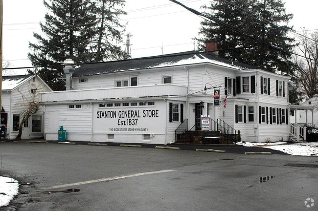
Property Record
171 Stanton Rd, Flemington, NJ 08822

Property Detail
171 Stanton Rd
22-00050-0000-00006
Hunterdon
Retailwithmorethanonenonretailuse
New Jersey
HR
6
B and X Area of moderate flood hazard, usually the area between the limits of the 100-year and 500-year floods.
0.86 AC
2024
Hunterdon
2025
Northern New Jersey
011204
Newark, NJ
4,497 SF
NEARBY LISTINGS FOR SALE OR LEASE
-
-
View all Flemington listings for sale on LoopNet.com
DEMOGRAPHICS near 171 Stanton Rd
1 mile
3 mile
5 mile
2025 Total Population
693
8,682
35,090
2030 Population
703
8,860
35,974
Pop Growth 2025-2030
+ 1.44%
+ 2.05%
+ 2.52%
Average Age
45
44
44
2025 Total Households
243
2,979
13,257
HH Growth 2025-2030
+ 1.23%
+ 2.08%
+ 2.51%
Median Household Inc
$180,208
$206,494
$146,102
Avg Household Size
2.80
2.90
2.60
2025 Avg HH Vehicles
3.00
3.00
2.00
Median Home Value
$703,781
$680,773
$572,608
Median Year Built
1971
1979
1981
Nearby Places
Map Layers
Map Styles
 Street
 Aerial
Transit
 Traffic
 Biking
Places
Listings with unknown addresses are not visible on the map
- Restaurants
- Banks
- Shops
- Fitness
- Groceries
PUBLIC TRANSPORTATION
COMMUTER RAIL
White House (Raritan Valley Line - NJ Transit Commuter Rail (NJ Transit))
Drive
Walk
Distance
White House (Raritan Valley Line - NJ Transit Commuter Rail (NJ Transit))
14 min
5.5 mi
Annandale (Raritan Valley Line - NJ Transit Commuter Rail (NJ Transit))
Drive
Walk
Distance
Annandale (Raritan Valley Line - NJ Transit Commuter Rail (NJ Transit))
12 min
6.4 mi
AIRPORT
Trenton Mercer
Drive
Walk
Distance
Trenton Mercer
44 min
26.9 mi
Lehigh Valley International
Drive
Walk
Distance
Lehigh Valley International
58 min
39.2 mi
Freight Ports
New York Container Terminal
Drive
Walk
Distance
New York Container Terminal
67 min
46.5 mi
SALE & LEASE HISTORY
LISTING DATE
SALE/LEASE

Sep 28, 2016
For Sale
Sep 25, 2016
For Lease
Nearby Properties
Address
Land Use
TOTAL SIZE
Lot Size
Zoning
Address
Land Use
TOTAL SIZE
Lot Size
Zoning
11.90 AC
CR
Address
Land Use
TOTAL SIZE
Lot Size
Zoning
26.03 AC
I-2
Address
Land Use
TOTAL SIZE
Lot Size
Zoning
108.22 AC
I-2
Address
Land Use
TOTAL SIZE
Lot Size
Zoning
31.46 AC
R-3
Address
Land Use
TOTAL SIZE
Lot Size
Zoning
4.51 AC
R-3
Address
Land Use
TOTAL SIZE
Lot Size
Zoning
16.01 AC
I-2
Address
Land Use
TOTAL SIZE
Lot Size
Zoning
7.99 AC
CR
Address
Land Use
TOTAL SIZE
Lot Size
Zoning
13.56 AC
CR
Address
Land Use
TOTAL SIZE
Lot Size
Zoning
10.20 AC
OB1
Address
Land Use
TOTAL SIZE
Lot Size
Zoning
2,360 SF
36.04 AC
I-2
Address
Land Use
TOTAL SIZE
Lot Size
Zoning
13.74 AC
O-1
Address
Land Use
TOTAL SIZE
Lot Size
Zoning
8.74 AC
I-2
Address
Land Use
TOTAL SIZE
Lot Size
Zoning
4.55 AC
CR
Address
Land Use
TOTAL SIZE
Lot Size
Zoning
46.81 AC
AR
Address
Land Use
TOTAL SIZE
Lot Size
Zoning
5.01 AC
R-3
Address
Land Use
TOTAL SIZE
Lot Size
Zoning
35 AC
I-2
Address
Land Use
TOTAL SIZE
Lot Size
Zoning
1.60 AC
O-1
Address
Land Use
TOTAL SIZE
Lot Size
Zoning
2,087 SF
4.12 AC
ROM2
Address
Land Use
TOTAL SIZE
Lot Size
Zoning
6,618 SF
43.45 AC
RC
Address
Land Use
TOTAL SIZE
Lot Size
Zoning
5.80 AC
OB1
Address
Land Use
TOTAL SIZE
Lot Size
Zoning
28,430 SF
5 AC
AR
Address
Land Use
TOTAL SIZE
Lot Size
Zoning
104.23 AC
AR
Address
Land Use
TOTAL SIZE
Lot Size
Zoning
2,148 SF
2.67 AC
CR
Address
Land Use
TOTAL SIZE
Lot Size
Zoning
7.89 AC
R-3
Address
Land Use
TOTAL SIZE
Lot Size
Zoning
22,358 SF
2.81 AC
C1
Address
Land Use
TOTAL SIZE
Lot Size
Zoning
1,344 SF
0.97 AC
CR
Address
Land Use
TOTAL SIZE
Lot Size
Zoning
17.52 AC
I-2
Address
Land Use
TOTAL SIZE
Lot Size
Zoning
16.58 AC
I-2
Address
Land Use
TOTAL SIZE
Lot Size
Zoning
3,683 SF
4.84 AC
C1
Address
Land Use
TOTAL SIZE
Lot Size
Zoning
8,148 SF
7.75 AC
R-1
The World's #1 Commercial Real Estate Marketplace
Connect with us
© 2026 CoStar Group
The information above has been obtained from sources believed reliable. While we do not doubt its accuracy we have not verified it and make no guarantee, warranty or representation about it. It is your responsibility to independently confirm its accuracy and completeness. Any projections, opinions, assumptions, or estimates used are for example only and do not represent the current or future performance of the property. The value of this transaction to you depends on tax and other factors which should be evaluated by your tax, financial, and legal advisors. You and your advisors should conduct a careful, independent investigation of the property to determine to your satisfaction the suitability of the property for your needs.