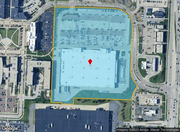
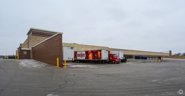
Property Record
171 W Town Square Way, Oak Creek, WI 53154

NEARBY LISTINGS FOR SALE OR LEASE
Property Detail
171 W Town Square Way
Milwaukee-Waukesha-West Allis, WI
CSM NO 8572 NE 1/4 SEC 17-5-22 LOT 1
813-9027-000
Milwaukee
Commercialnec
Wisconsin
X
1
55079C0168E
15.92 AC
2024
Milwaukee SE
2024
Milwaukee/Madison
160203
DEMOGRAPHICS near 171 W Town Square Way
1 Mile
3 Mile
5 Mile
2024 Total Population
7,886
51,518
130,128
2029 Population
7,823
50,136
126,393
Pop Growth 2024-2029
(0.80%)
(2.68%)
(2.87%)
Average Age
39
41
41
2024 Total Households
3,396
21,576
53,165
HH Growth 2024-2029
(0.74%)
(2.71%)
(2.97%)
Median Household Inc
$74,524
$78,259
$73,227
Avg Household Size
2.30
2.30
2.40
2024 Avg HH Vehicles
2.00
2.00
2.00
Median Home Value
$265,672
$255,493
$242,406
Median Year Built
1993
1979
1971
Nearby Places
Map Layers
Map Styles
 Street
 Aerial
- Restaurants
- Banks
- Shops
- Fitness
- Groceries
PUBLIC TRANSPORTATION
COMMUTER RAIL
General Mitchell Intl. Airport Amtrak Station (Hiawatha Service - Amtrak)
DRIVE
WALK
Distance
General Mitchell Intl. Airport Amtrak Station (Hiawatha Service - Amtrak)
9 min
4.1 mi
AIRPORT
General Mitchell International
DRIVE
WALK
Distance
General Mitchell International
9 min
4.3 mi
Freight Ports
Port Milwaukee
DRIVE
WALK
Distance
Port Milwaukee
16 min
10.0 mi
SALE & LEASE HISTORY
LISTING DATE
SALE/LEASE

Mar 16, 2023
For Lease
Apr 13, 2017
For Lease
Nearby Properties
Address
Land Use
TOTAL SIZE
Lot Size
Zoning
Address
Land Use
TOTAL SIZE
Lot Size
Zoning
75.05 AC
Address
Land Use
TOTAL SIZE
Lot Size
Zoning
Address
Land Use
TOTAL SIZE
Lot Size
Zoning
33.80 AC
Address
Land Use
TOTAL SIZE
Lot Size
Zoning
47.22 AC
RESIDENTIA
Address
Land Use
TOTAL SIZE
Lot Size
Zoning
28.76 AC
Address
Land Use
TOTAL SIZE
Lot Size
Zoning
3.15 AC
Address
Land Use
TOTAL SIZE
Lot Size
Zoning
6.90 AC
Address
Land Use
TOTAL SIZE
Lot Size
Zoning
Address
Land Use
TOTAL SIZE
Lot Size
Zoning
16.06 AC
Address
Land Use
TOTAL SIZE
Lot Size
Zoning
3.45 AC
Address
Land Use
TOTAL SIZE
Lot Size
Zoning
2.53 AC
Address
Land Use
TOTAL SIZE
Lot Size
Zoning
41.93 AC
Address
Land Use
TOTAL SIZE
Lot Size
Zoning
27.30 AC
RESIDENTIA
Address
Land Use
TOTAL SIZE
Lot Size
Zoning
63,273 SF
5.42 AC
Address
Land Use
TOTAL SIZE
Lot Size
Zoning
8.79 AC
RESIDENTIA
Address
Land Use
TOTAL SIZE
Lot Size
Zoning
18.39 AC
RESIDENTIA
Address
Land Use
TOTAL SIZE
Lot Size
Zoning
26.21 AC
Address
Land Use
TOTAL SIZE
Lot Size
Zoning
48.65 AC
Address
Land Use
TOTAL SIZE
Lot Size
Zoning
21.72 AC
RESIDENTIA
Address
Land Use
TOTAL SIZE
Lot Size
Zoning
9.24 AC
RESIDENTIA
Address
Land Use
TOTAL SIZE
Lot Size
Zoning
16.48 AC
Address
Land Use
TOTAL SIZE
Lot Size
Zoning
14.24 AC
RESIDENTIA
Address
Land Use
TOTAL SIZE
Lot Size
Zoning
7.36 AC
RESIDENTIA
Address
Land Use
TOTAL SIZE
Lot Size
Zoning
28.04 AC
Address
Land Use
TOTAL SIZE
Lot Size
Zoning
14.03 AC
RESIDENTIA
Address
Land Use
TOTAL SIZE
Lot Size
Zoning
10.78 AC
Address
Land Use
TOTAL SIZE
Lot Size
Zoning
378,000 SF
19.24 AC
M-1PUD
Address
Land Use
TOTAL SIZE
Lot Size
Zoning
4.72 AC
Address
Land Use
TOTAL SIZE
Lot Size
Zoning
9.55 AC
RESIDENTIA
The World's #1 Commercial Real Estate Marketplace
Connect with us
© 2025 CoStar Group
The information above has been obtained from sources believed reliable. While we do not doubt its accuracy we have not verified it and make no guarantee, warranty or representation about it. It is your responsibility to independently confirm its accuracy and completeness. Any projections, opinions, assumptions, or estimates used are for example only and do not represent the current or future performance of the property. The value of this transaction to you depends on tax and other factors which should be evaluated by your tax, financial, and legal advisors. You and your advisors should conduct a careful, independent investigation of the property to determine to your satisfaction the suitability of the property for your needs.