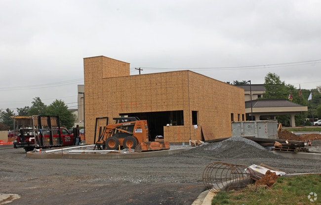
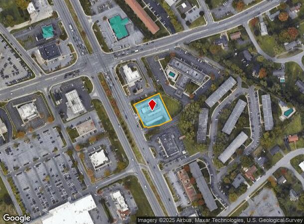
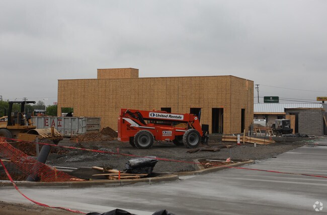
Property Record
1710 Dual Hwy, Hagerstown, MD 21740
NEARBY LISTINGS FOR SALE OR LEASE
Property Detail
1710 Dual Hwy
17-003658
Falling Spg Corp
Restaurantdrivein
PARCEL 1 0.623 ACRE 1710 DUAL HWY
X
Washington
24043C0302D
Maryland
2024
0.62 AC
2025
Washington County
011100
Washington, DC
1,539 SF
Hagerstown-Martinsburg, MD-WV
DEMOGRAPHICS near 1710 Dual Hwy
1 Mile
3 Mile
5 Mile
2024 Total Population
5,783
47,746
87,913
2029 Population
5,866
48,546
89,175
Pop Growth 2024-2029
+ 1.44%
+ 1.68%
+ 1.44%
Average Age
44
40
40
2024 Total Households
2,521
19,843
35,139
HH Growth 2024-2029
+ 1.43%
+ 1.66%
+ 1.47%
Median Household Inc
$55,193
$48,416
$57,616
Avg Household Size
2.30
2.30
2.40
2024 Avg HH Vehicles
2.00
2.00
2.00
Median Home Value
$234,607
$197,770
$216,965
Median Year Built
1978
1969
1971
Nearby Places
Map Layers
Map Styles
 Street
 Aerial
- Restaurants
- Banks
- Shops
- Fitness
- Groceries
PUBLIC TRANSPORTATION
AIRPORT
Hagerstown Regional/Richard A Henson Field
DRIVE
WALK
Distance
Hagerstown Regional/Richard A Henson Field
14 min
7.4 mi
Freight Ports
Port of Baltimore
DRIVE
WALK
Distance
Port of Baltimore
87 min
72.7 mi
Nearby Properties
Address
Land Use
TOTAL SIZE
Lot Size
Zoning
Address
Land Use
TOTAL SIZE
Lot Size
Zoning
502,262 SF
36.64 AC
ORI
Address
Land Use
TOTAL SIZE
Lot Size
Zoning
1,236,085 SF
134.31 AC
IMU
Address
Land Use
TOTAL SIZE
Lot Size
Zoning
77,027 SF
310.67 AC
ERT
Address
Land Use
TOTAL SIZE
Lot Size
Zoning
1,247,111 SF
74.55 AC
IMU
Address
Land Use
TOTAL SIZE
Lot Size
Zoning
103,131 SF
53.74 AC
RMOD
Address
Land Use
TOTAL SIZE
Lot Size
Zoning
200,815 SF
9.14 AC
ORI
Address
Land Use
TOTAL SIZE
Lot Size
Zoning
12,580 SF
1.73 AC
CCMU
Address
Land Use
TOTAL SIZE
Lot Size
Zoning
167,084 SF
64.62 AC
RMOD
Address
Land Use
TOTAL SIZE
Lot Size
Zoning
77,934 SF
12.79 AC
RMED
Address
Land Use
TOTAL SIZE
Lot Size
Zoning
82,403 SF
1.32 AC
CCMU
Address
Land Use
TOTAL SIZE
Lot Size
Zoning
290,600 SF
51.35 AC
IMU
Address
Land Use
TOTAL SIZE
Lot Size
Zoning
52,259 SF
60.86 AC
HI
Address
Land Use
TOTAL SIZE
Lot Size
Zoning
7,427 SF
79.25 AC
RS
Address
Land Use
TOTAL SIZE
Lot Size
Zoning
94,185 SF
9.25 AC
RMED
Address
Land Use
TOTAL SIZE
Lot Size
Zoning
88,116 SF
18.44 AC
RMOD
Address
Land Use
TOTAL SIZE
Lot Size
Zoning
67,434 SF
4.30 AC
RS
Address
Land Use
TOTAL SIZE
Lot Size
Zoning
80,816 SF
19.68 AC
ORI
Address
Land Use
TOTAL SIZE
Lot Size
Zoning
17,574 SF
13.98 AC
RH
Address
Land Use
TOTAL SIZE
Lot Size
Zoning
198 SF
7.04 AC
RH
Address
Land Use
TOTAL SIZE
Lot Size
Zoning
8,546 SF
4 AC
IG
Address
Land Use
TOTAL SIZE
Lot Size
Zoning
18,799 SF
0.75 AC
CCMU
Address
Land Use
TOTAL SIZE
Lot Size
Zoning
54,843 SF
3.08 AC
POM
Address
Land Use
TOTAL SIZE
Lot Size
Zoning
138,132 SF
22.90 AC
HI
Address
Land Use
TOTAL SIZE
Lot Size
Zoning
272,643 SF
5.22 AC
RH
Address
Land Use
TOTAL SIZE
Lot Size
Zoning
28,584 SF
4.13 AC
HI
Address
Land Use
TOTAL SIZE
Lot Size
Zoning
31,816 SF
0.47 AC
CCMU
Address
Land Use
TOTAL SIZE
Lot Size
Zoning
56,400 SF
0.27 AC
CCMU
Address
Land Use
TOTAL SIZE
Lot Size
Zoning
1,516 SF
9.39 AC
CG
Address
Land Use
TOTAL SIZE
Lot Size
Zoning
20,157 SF
50 AC
RMOD
Address
Land Use
TOTAL SIZE
Lot Size
Zoning
29,405 SF
29.47 AC
RH
The World's #1 Commercial Real Estate Marketplace
Connect with us
© 2025 CoStar Group
The information above has been obtained from sources believed reliable. While we do not doubt its accuracy we have not verified it and make no guarantee, warranty or representation about it. It is your responsibility to independently confirm its accuracy and completeness. Any projections, opinions, assumptions, or estimates used are for example only and do not represent the current or future performance of the property. The value of this transaction to you depends on tax and other factors which should be evaluated by your tax, financial, and legal advisors. You and your advisors should conduct a careful, independent investigation of the property to determine to your satisfaction the suitability of the property for your needs.