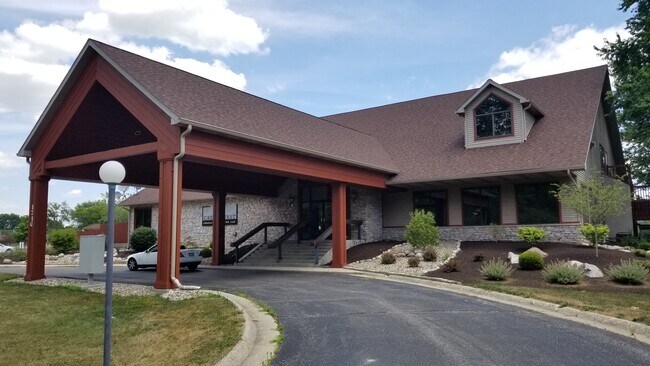
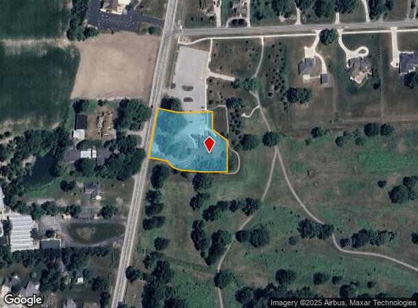
Property Record
1710 N Main St, Auburn, IN 46706


NEARBY LISTINGS FOR SALE OR LEASE
Property Detail
1710 N Main St
17-06-29-127-009.000-025
Frothingham And Hornbergers
Officebuilding
PT NE COR NW1/4 SECTION 29 TWP 34 RANGE 13 ACRES 1.646
X
Dekalb
18033C0143E
Indiana
2024
1.65 AC
2024
Fort Wayne
020400
Other Market Areas
17,670 SF
Auburn, IN
DEMOGRAPHICS near 1710 N Main St
1 Mile
3 Mile
5 Mile
2024 Total Population
4,676
15,948
25,826
2029 Population
4,822
16,444
26,587
Pop Growth 2024-2029
+ 3.12%
+ 3.11%
+ 2.95%
Average Age
41
41
40
2024 Total Households
1,908
6,611
10,325
HH Growth 2024-2029
+ 3.09%
+ 3.13%
+ 2.93%
Median Household Inc
$61,931
$58,646
$60,752
Avg Household Size
2.30
2.30
2.40
2024 Avg HH Vehicles
2.00
2.00
2.00
Median Home Value
$160,605
$154,306
$158,001
Median Year Built
1978
1981
1980
Nearby Places
Map Layers
Map Styles
 Street
 Aerial
- Restaurants
- Banks
- Shops
- Fitness
- Groceries
PUBLIC TRANSPORTATION
COMMUTER RAIL
DRIVE
WALK
Distance
8 min
4.0 mi
AIRPORT
Fort Wayne International
DRIVE
WALK
Distance
Fort Wayne International
49 min
37.3 mi
SALE & LEASE HISTORY
LISTING DATE
SALE/LEASE

Jan 12, 2018
For Lease
Aug 06, 2020
For Sale
Apr 19, 2022
For Sale
Nearby Properties
Address
Land Use
TOTAL SIZE
Lot Size
Zoning
Address
Land Use
TOTAL SIZE
Lot Size
Zoning
77,765 SF
24.02 AC
Address
Land Use
TOTAL SIZE
Lot Size
Zoning
59,049 SF
12.73 AC
Address
Land Use
TOTAL SIZE
Lot Size
Zoning
180,835 SF
18.82 AC
Address
Land Use
TOTAL SIZE
Lot Size
Zoning
186,496 SF
29.28 AC
Address
Land Use
TOTAL SIZE
Lot Size
Zoning
15,960 SF
3.09 AC
Address
Land Use
TOTAL SIZE
Lot Size
Zoning
13,200 SF
49.95 AC
Address
Land Use
TOTAL SIZE
Lot Size
Zoning
26,488 SF
12.12 AC
Address
Land Use
TOTAL SIZE
Lot Size
Zoning
400 SF
7.70 AC
Address
Land Use
TOTAL SIZE
Lot Size
Zoning
6,000 SF
42.17 AC
Address
Land Use
TOTAL SIZE
Lot Size
Zoning
37,152 SF
7.81 AC
Address
Land Use
TOTAL SIZE
Lot Size
Zoning
130,185 SF
34.82 AC
Address
Land Use
TOTAL SIZE
Lot Size
Zoning
28,390 SF
0.09 AC
Address
Land Use
TOTAL SIZE
Lot Size
Zoning
18,976 SF
4.13 AC
Address
Land Use
TOTAL SIZE
Lot Size
Zoning
50,876 SF
4.04 AC
Address
Land Use
TOTAL SIZE
Lot Size
Zoning
45,874 SF
3.94 AC
Address
Land Use
TOTAL SIZE
Lot Size
Zoning
95,148 SF
14.02 AC
Address
Land Use
TOTAL SIZE
Lot Size
Zoning
87,840 SF
7.12 AC
Address
Land Use
TOTAL SIZE
Lot Size
Zoning
14,760 SF
6.54 AC
Address
Land Use
TOTAL SIZE
Lot Size
Zoning
5,184 SF
113.45 AC
Address
Land Use
TOTAL SIZE
Lot Size
Zoning
103,888 SF
30 AC
Address
Land Use
TOTAL SIZE
Lot Size
Zoning
4,048 SF
14.92 AC
Address
Land Use
TOTAL SIZE
Lot Size
Zoning
75,878 SF
1.05 AC
Address
Land Use
TOTAL SIZE
Lot Size
Zoning
20,420 SF
4.70 AC
Address
Land Use
TOTAL SIZE
Lot Size
Zoning
38,708 SF
1.55 AC
Address
Land Use
TOTAL SIZE
Lot Size
Zoning
22,000 SF
7.90 AC
Address
Land Use
TOTAL SIZE
Lot Size
Zoning
19,936 SF
10.47 AC
Address
Land Use
TOTAL SIZE
Lot Size
Zoning
57,886 SF
19.56 AC
Address
Land Use
TOTAL SIZE
Lot Size
Zoning
62,856 SF
1.80 AC
Address
Land Use
TOTAL SIZE
Lot Size
Zoning
48,000 SF
5.29 AC
Address
Land Use
TOTAL SIZE
Lot Size
Zoning
14,440 SF
0.21 AC
The World's #1 Commercial Real Estate Marketplace
Connect with us
© 2025 CoStar Group
The information above has been obtained from sources believed reliable. While we do not doubt its accuracy we have not verified it and make no guarantee, warranty or representation about it. It is your responsibility to independently confirm its accuracy and completeness. Any projections, opinions, assumptions, or estimates used are for example only and do not represent the current or future performance of the property. The value of this transaction to you depends on tax and other factors which should be evaluated by your tax, financial, and legal advisors. You and your advisors should conduct a careful, independent investigation of the property to determine to your satisfaction the suitability of the property for your needs.