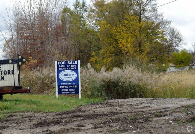
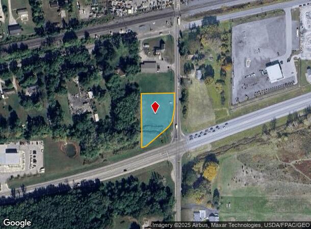
Property Record
1710 S Crissey Rd, Monclova, OH 43542
NEARBY LISTINGS FOR SALE OR LEASE
Property Detail
1710 S Crissey Rd
65-37516
10 8 31 IRREG 1.468 AC PCE S OLD AIRPORT HWY & RR MEAS
Recreationalacreage
Lucas
AE
Ohio
39095C0207E
1.47 AC
2025
South/Southwest
2025
Toledo
009104
Toledo, OH
DEMOGRAPHICS near 1710 S Crissey Rd
1 mile
3 mile
5 mile
2024 Total Population
675
15,880
60,318
2029 Population
659
15,468
59,397
Pop Growth 2024-2029
(2.37%)
(2.59%)
(1.53%)
Average Age
45
43
42
2024 Total Households
215
6,094
25,058
HH Growth 2024-2029
(2.79%)
(2.72%)
(1.38%)
Median Household Inc
$107,812
$99,640
$75,828
Avg Household Size
2.60
2.50
2.30
2024 Avg HH Vehicles
3.00
2.00
2.00
Median Home Value
$233,980
$273,763
$238,287
Median Year Built
1985
1993
1986
Nearby Places
Map Layers
Map Styles
 Street
 Aerial
Transit
 Traffic
 Biking
Places
Listings with unknown addresses are not visible on the map
- Restaurants
- Banks
- Shops
- Fitness
- Groceries
PUBLIC TRANSPORTATION
AIRPORT
Eugene F Kranz Toledo Express
Drive
Walk
Distance
Eugene F Kranz Toledo Express
16 min
7.1 mi
Freight Ports
Port of Toledo
Drive
Walk
Distance
Port of Toledo
32 min
18.0 mi
Nearby Properties
Address
Land Use
TOTAL SIZE
Lot Size
Zoning
Address
Land Use
TOTAL SIZE
Lot Size
Zoning
178,278 SF
399.08 AC
33-A
Address
Land Use
TOTAL SIZE
Lot Size
Zoning
372,117 SF
35 AC
17-AR
Address
Land Use
TOTAL SIZE
Lot Size
Zoning
178,915 SF
13 AC
19-R3
Address
Land Use
TOTAL SIZE
Lot Size
Zoning
203,839 SF
16.39 AC
24-SUP
Address
Land Use
TOTAL SIZE
Lot Size
Zoning
1,176 SF
626.54 AC
17-AR
Address
Land Use
TOTAL SIZE
Lot Size
Zoning
156,420 SF
12 AC
19-R3
Address
Land Use
TOTAL SIZE
Lot Size
Zoning
238,148 SF
18.20 AC
24-B3
Address
Land Use
TOTAL SIZE
Lot Size
Zoning
120,077 SF
9.53 AC
24-B3
Address
Land Use
TOTAL SIZE
Lot Size
Zoning
1,704 SF
74 AC
19-MX
Address
Land Use
TOTAL SIZE
Lot Size
Zoning
103,406 SF
7.55 AC
24-SUP
Address
Land Use
TOTAL SIZE
Lot Size
Zoning
131,800 SF
9.55 AC
33-M1
Address
Land Use
TOTAL SIZE
Lot Size
Zoning
106,687 SF
11.48 AC
19-RA3
Address
Land Use
TOTAL SIZE
Lot Size
Zoning
587,559 SF
45 AC
30-M1
Address
Land Use
TOTAL SIZE
Lot Size
Zoning
135,296 SF
27.36 AC
19-M1
Address
Land Use
TOTAL SIZE
Lot Size
Zoning
128,825 SF
10.18 AC
19-M1
Address
Land Use
TOTAL SIZE
Lot Size
Zoning
68,776 SF
6.78 AC
19-R3
Address
Land Use
TOTAL SIZE
Lot Size
Zoning
45.57 AC
30-M1
Address
Land Use
TOTAL SIZE
Lot Size
Zoning
148,680 SF
8.50 AC
19-M3
Address
Land Use
TOTAL SIZE
Lot Size
Zoning
69,061 SF
7.50 AC
19-RA3
Address
Land Use
TOTAL SIZE
Lot Size
Zoning
65,576 SF
4.35 AC
19-M1
Address
Land Use
TOTAL SIZE
Lot Size
Zoning
30,120 SF
6.99 AC
19-C2
Address
Land Use
TOTAL SIZE
Lot Size
Zoning
60,771 SF
2.87 AC
24-SUP
Address
Land Use
TOTAL SIZE
Lot Size
Zoning
323,240 SF
21.09 AC
33-A
Address
Land Use
TOTAL SIZE
Lot Size
Zoning
4,464 SF
1.16 AC
24-B3
Address
Land Use
TOTAL SIZE
Lot Size
Zoning
100,000 SF
6.70 AC
33-M1
Address
Land Use
TOTAL SIZE
Lot Size
Zoning
52,636 SF
6.18 AC
19-M1
Address
Land Use
TOTAL SIZE
Lot Size
Zoning
84,260 SF
13.21 AC
24-SUP
Address
Land Use
TOTAL SIZE
Lot Size
Zoning
35,520 SF
122 AC
19-RA4
Address
Land Use
TOTAL SIZE
Lot Size
Zoning
14,357 SF
2.70 AC
19-C2
Address
Land Use
TOTAL SIZE
Lot Size
Zoning
102,232 SF
6.29 AC
33-MX
The World's #1 Commercial Real Estate Marketplace
Connect with us
© 2026 CoStar Group
The information above has been obtained from sources believed reliable. While we do not doubt its accuracy we have not verified it and make no guarantee, warranty or representation about it. It is your responsibility to independently confirm its accuracy and completeness. Any projections, opinions, assumptions, or estimates used are for example only and do not represent the current or future performance of the property. The value of this transaction to you depends on tax and other factors which should be evaluated by your tax, financial, and legal advisors. You and your advisors should conduct a careful, independent investigation of the property to determine to your satisfaction the suitability of the property for your needs.