Property Record
1710 Woodcreek Farms Rd, Elgin, SC 29045
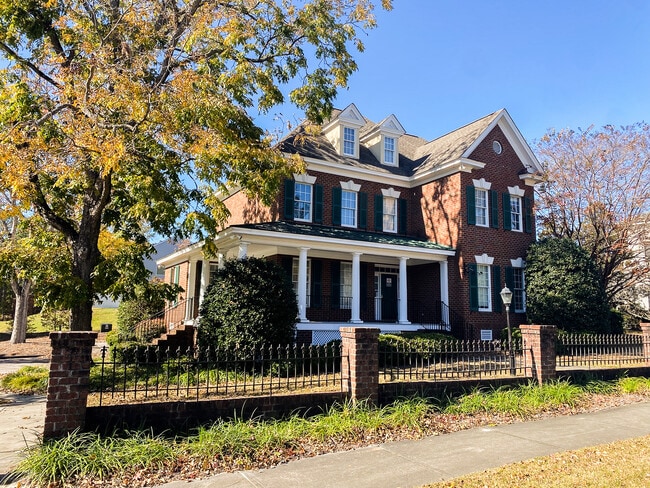
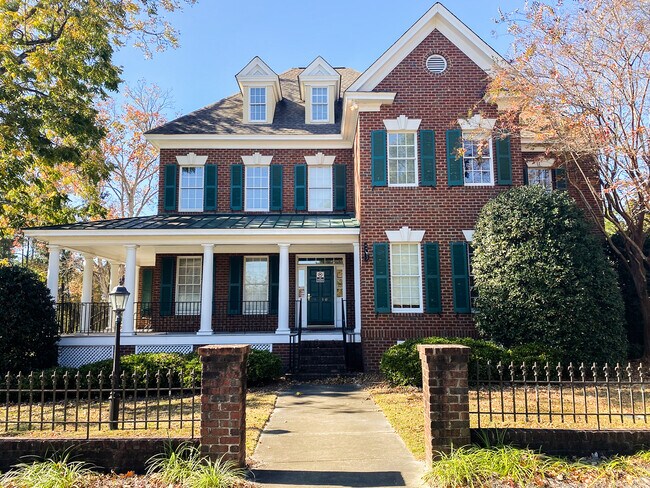
This Property Is For Sale
NEARBY LISTINGS FOR SALE OR LEASE
Property Detail
1710 Woodcreek Farms Rd
28902-04-01
Palmetto Utilities
Commercialnec
PARCEL D 119.6X119.1X111.7X128.3 #SU #PR RB385-968
X
Richland
45079C0277L
South Carolina
2025
0.33 AC
2024
Northeast Columbia
011407
Columbia
4,431 SF
Columbia, SC
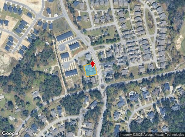
DEMOGRAPHICS near 1710 Woodcreek Farms Rd
1 Mile
3 Mile
5 Mile
2024 Total Population
4,250
27,535
72,922
2029 Population
4,533
28,838
75,758
Pop Growth 2024-2029
+ 6.66%
+ 4.73%
+ 3.89%
Average Age
39
39
39
2024 Total Households
1,673
10,838
28,366
HH Growth 2024-2029
+ 6.75%
+ 4.90%
+ 3.98%
Median Household Inc
$108,079
$86,527
$80,201
Avg Household Size
2.50
2.50
2.50
2024 Avg HH Vehicles
2.00
2.00
2.00
Median Home Value
$366,110
$269,100
$259,102
Median Year Built
2010
2002
2000
Nearby Places
- Restaurants
- Banks
- Shops
- Fitness
- Groceries
PUBLIC TRANSPORTATION
AIRPORT
Columbia Metro
DRIVE
WALK
Distance
Columbia Metro
47 min
27.3 mi
Freight Ports
North Charleston Terminal
DRIVE
WALK
Distance
North Charleston Terminal
141 min
120.7 mi
Nearby Properties
Address
Land Use
TOTAL SIZE
Lot Size
Zoning
Address
Land Use
TOTAL SIZE
Lot Size
Zoning
333,002 SF
8.39 AC
GC
Address
Land Use
TOTAL SIZE
Lot Size
Zoning
298,100 SF
74.42 AC
C-3
Address
Land Use
TOTAL SIZE
Lot Size
Zoning
244,269 SF
9.54 AC
GC
Address
Land Use
TOTAL SIZE
Lot Size
Zoning
563.44 AC
OI
Address
Land Use
TOTAL SIZE
Lot Size
Zoning
329,677 SF
17.12 AC
PDD
Address
Land Use
TOTAL SIZE
Lot Size
Zoning
313,664 SF
33.91 AC
RG-2
Address
Land Use
TOTAL SIZE
Lot Size
Zoning
298,080 SF
18.10 AC
RU
Address
Land Use
TOTAL SIZE
Lot Size
Zoning
299,353 SF
12.36 AC
GC
Address
Land Use
TOTAL SIZE
Lot Size
Zoning
210,926 SF
22 AC
HI
Address
Land Use
TOTAL SIZE
Lot Size
Zoning
360,163 SF
20.11 AC
RM-MD
Address
Land Use
TOTAL SIZE
Lot Size
Zoning
245,825 SF
11 AC
RS-2
Address
Land Use
TOTAL SIZE
Lot Size
Zoning
91,672 SF
12.18 AC
GC
Address
Land Use
TOTAL SIZE
Lot Size
Zoning
179,808 SF
12.85 AC
RM-HD
Address
Land Use
TOTAL SIZE
Lot Size
Zoning
275,286 SF
15.53 AC
PD
Address
Land Use
TOTAL SIZE
Lot Size
Zoning
138,480 SF
23.02 AC
GC
Address
Land Use
TOTAL SIZE
Lot Size
Zoning
66,821 SF
6.32 AC
OI
Address
Land Use
TOTAL SIZE
Lot Size
Zoning
31,625 SF
3.30 AC
GC
Address
Land Use
TOTAL SIZE
Lot Size
Zoning
84,860 SF
5.13 AC
PUD-R
Address
Land Use
TOTAL SIZE
Lot Size
Zoning
73,192 SF
6.12 AC
GC
Address
Land Use
TOTAL SIZE
Lot Size
Zoning
81,951 SF
11.81 AC
M-1
Address
Land Use
TOTAL SIZE
Lot Size
Zoning
194,728 SF
12.28 AC
RM-MD
Address
Land Use
TOTAL SIZE
Lot Size
Zoning
161,727 SF
13.25 AC
GC
Address
Land Use
TOTAL SIZE
Lot Size
Zoning
87,363 SF
10.61 AC
M-1
Address
Land Use
TOTAL SIZE
Lot Size
Zoning
118,547 SF
10.64 AC
GC
Address
Land Use
TOTAL SIZE
Lot Size
Zoning
126,352 SF
10.43 AC
M-1
Address
Land Use
TOTAL SIZE
Lot Size
Zoning
53,984 SF
15 AC
C-3
Address
Land Use
TOTAL SIZE
Lot Size
Zoning
78,282 SF
8.52 AC
M-1
Address
Land Use
TOTAL SIZE
Lot Size
Zoning
2,420 SF
4.03 AC
M-1
Address
Land Use
TOTAL SIZE
Lot Size
Zoning
45,284 SF
4.70 AC
GC
Address
Land Use
TOTAL SIZE
Lot Size
Zoning
86,776 SF
6.43 AC
OI
The World's #1 Commercial Real Estate Marketplace
Connect with us
© 2025 CoStar Group
The information above has been obtained from sources believed reliable. While we do not doubt its accuracy we have not verified it and make no guarantee, warranty or representation about it. It is your responsibility to independently confirm its accuracy and completeness. Any projections, opinions, assumptions, or estimates used are for example only and do not represent the current or future performance of the property. The value of this transaction to you depends on tax and other factors which should be evaluated by your tax, financial, and legal advisors. You and your advisors should conduct a careful, independent investigation of the property to determine to your satisfaction the suitability of the property for your needs.