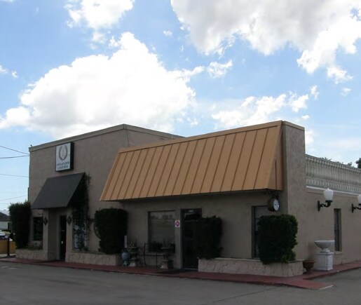
Property Record
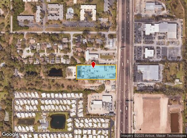
17116 Us Highway 19 N, Clearwater, FL 33764

NEARBY LISTINGS FOR SALE OR LEASE
Property Detail
17116 Us Highway 19 N
Tampa-St. Petersburg-Clearwater, FL
Maple Leaf Farms Sub
30-29-16-55044-000-0021
MAPLE LEAF FARMS SUB PT OF LOT 2 DESC AS FR NE COR OF LOT 2 FOR POB TH S01D0159W 161.55FT TH N89D3521W 450FT TH N01D0152E 161.59FT TH S89D3617E 450FT TO POB
Storebuilding
Pinellas
X
Florida
12103C0136H
2
2024
1.67 AC
2025
Bayside
025414
Tampa/St Petersburg
6,640 SF
DEMOGRAPHICS near 17116 Us Highway 19 N
1 Mile
3 Mile
5 Mile
2024 Total Population
12,707
96,841
226,893
2029 Population
12,830
97,749
228,264
Pop Growth 2024-2029
+ 0.97%
+ 0.94%
+ 0.60%
Average Age
45
45
45
2024 Total Households
6,278
45,170
103,125
HH Growth 2024-2029
+ 0.81%
+ 0.89%
+ 0.51%
Median Household Inc
$58,409
$55,887
$55,206
Avg Household Size
2.00
2.10
2.10
2024 Avg HH Vehicles
2.00
2.00
2.00
Median Home Value
$231,552
$211,750
$229,742
Median Year Built
1978
1977
1976
Nearby Places
Map Layers
Map Styles
 Street
 Aerial
- Restaurants
- Banks
- Shops
- Fitness
- Groceries
PUBLIC TRANSPORTATION
AIRPORT
St Pete-Clearwater International
DRIVE
WALK
Distance
St Pete-Clearwater International
18 min
7.1 mi
Tampa International
DRIVE
WALK
Distance
Tampa International
28 min
16.6 mi
Freight Ports
Port of Tampa Bay
DRIVE
WALK
Distance
Port of Tampa Bay
40 min
23.9 mi
Nearby Properties
Address
Land Use
TOTAL SIZE
Lot Size
Zoning
Address
Land Use
TOTAL SIZE
Lot Size
Zoning
795,890 SF
69.11 AC
M1
Address
Land Use
TOTAL SIZE
Lot Size
Zoning
130,544 SF
1,313.50 AC
PCAIRPOR
Address
Land Use
TOTAL SIZE
Lot Size
Zoning
524,588 SF
17.15 AC
Address
Land Use
TOTAL SIZE
Lot Size
Zoning
470,181 SF
29.93 AC
Address
Land Use
TOTAL SIZE
Lot Size
Zoning
389,810 SF
16.93 AC
Address
Land Use
TOTAL SIZE
Lot Size
Zoning
498,319 SF
15.52 AC
Address
Land Use
TOTAL SIZE
Lot Size
Zoning
452,179 SF
5.75 AC
R4
Address
Land Use
TOTAL SIZE
Lot Size
Zoning
288,467 SF
43.51 AC
Address
Land Use
TOTAL SIZE
Lot Size
Zoning
529,506 SF
23.06 AC
Address
Land Use
TOTAL SIZE
Lot Size
Zoning
305,970 SF
39.74 AC
Address
Land Use
TOTAL SIZE
Lot Size
Zoning
367,411 SF
16.12 AC
Address
Land Use
TOTAL SIZE
Lot Size
Zoning
382,389 SF
13.62 AC
Address
Land Use
TOTAL SIZE
Lot Size
Zoning
492,016 SF
19.86 AC
Address
Land Use
TOTAL SIZE
Lot Size
Zoning
313,486 SF
18.42 AC
Address
Land Use
TOTAL SIZE
Lot Size
Zoning
337,954 SF
21 AC
R3
Address
Land Use
TOTAL SIZE
Lot Size
Zoning
325,591 SF
31.97 AC
Address
Land Use
TOTAL SIZE
Lot Size
Zoning
588,657 SF
33 AC
Address
Land Use
TOTAL SIZE
Lot Size
Zoning
352,647 SF
14.88 AC
Address
Land Use
TOTAL SIZE
Lot Size
Zoning
364,675 SF
66.40 AC
AE
Address
Land Use
TOTAL SIZE
Lot Size
Zoning
384,124 SF
25.78 AC
C3
Address
Land Use
TOTAL SIZE
Lot Size
Zoning
284,609 SF
15.57 AC
Address
Land Use
TOTAL SIZE
Lot Size
Zoning
446,556 SF
14.95 AC
M1
Address
Land Use
TOTAL SIZE
Lot Size
Zoning
396,822 SF
36.20 AC
RPD5
Address
Land Use
TOTAL SIZE
Lot Size
Zoning
362,618 SF
40.19 AC
R6
Address
Land Use
TOTAL SIZE
Lot Size
Zoning
492,747 SF
19.89 AC
Address
Land Use
TOTAL SIZE
Lot Size
Zoning
266,396 SF
23.18 AC
Address
Land Use
TOTAL SIZE
Lot Size
Zoning
352,158 SF
47.45 AC
Address
Land Use
TOTAL SIZE
Lot Size
Zoning
160,014 SF
7.77 AC
Address
Land Use
TOTAL SIZE
Lot Size
Zoning
223,944 SF
12.13 AC
Address
Land Use
TOTAL SIZE
Lot Size
Zoning
244,655 SF
16.84 AC
AE
The World's #1 Commercial Real Estate Marketplace
Connect with us
© 2025 CoStar Group
The information above has been obtained from sources believed reliable. While we do not doubt its accuracy we have not verified it and make no guarantee, warranty or representation about it. It is your responsibility to independently confirm its accuracy and completeness. Any projections, opinions, assumptions, or estimates used are for example only and do not represent the current or future performance of the property. The value of this transaction to you depends on tax and other factors which should be evaluated by your tax, financial, and legal advisors. You and your advisors should conduct a careful, independent investigation of the property to determine to your satisfaction the suitability of the property for your needs.