Property Record
1712 Denver Ave, Fort Lupton, CO 80621
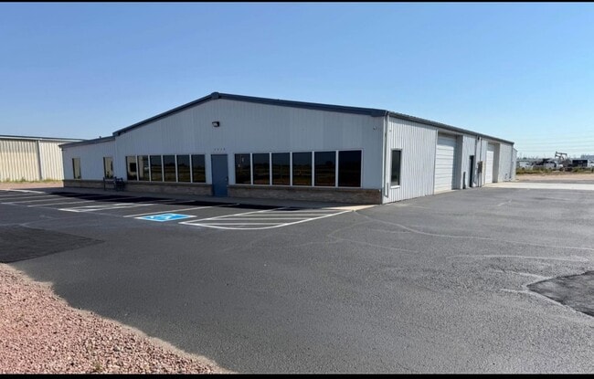

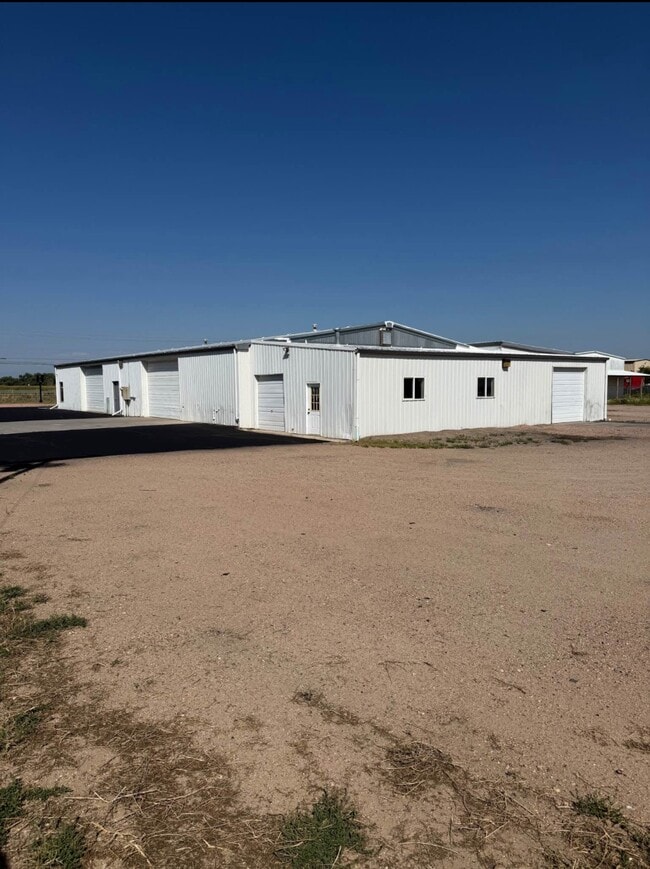
Property Detail
1712 Denver Ave
R5292386
16259A PT N2NW4 32 2 66 BEG 213.5 M/L N & 30E OF SW COR E375 N200 W375 S200 TO BEG
Warehouse
Weld
B and X Area of moderate flood hazard, usually the area between the limits of the 100-year and 500-year floods.
Colorado
2024
1.75 AC
2025
Weld County
001910
Denver
9,944 SF
Greeley, CO
NEARBY LISTINGS FOR SALE OR LEASE
DEMOGRAPHICS near 1712 Denver Ave
1 mile
3 mile
5 mile
2025 Total Population
3,811
12,476
14,311
2030 Population
4,235
13,940
15,943
Pop Growth 2025-2030
+ 11.13%
+ 11.73%
+ 11.40%
Average Age
37
39
39
2025 Total Households
1,232
4,189
4,809
HH Growth 2025-2030
+ 11.36%
+ 12.06%
+ 11.75%
Median Household Inc
$57,525
$78,299
$82,084
Avg Household Size
3.00
2.90
2.90
2025 Avg HH Vehicles
2.00
2.00
2.00
Median Home Value
$346,529
$406,619
$425,470
Median Year Built
1986
1989
1989
Nearby Places
Map Layers
Map Styles
 Street
 Aerial
Layers
 Traffic
 Biking
Places
Listings with unknown addresses are not visible on the map
- Restaurants
- Banks
- Shops
- Fitness
- Groceries
PUBLIC TRANSPORTATION
AIRPORT
Denver International
Drive
Walk
Distance
Denver International
39 min
29.1 mi
SALE & LEASE HISTORY
LISTING DATE
SALE/LEASE

Dec 11, 2025
For Lease
Nearby Properties
Address
Land Use
TOTAL SIZE
Lot Size
Zoning
Address
Land Use
TOTAL SIZE
Lot Size
Zoning
Address
Land Use
TOTAL SIZE
Lot Size
Zoning
276,393 SF
40 AC
Address
Land Use
TOTAL SIZE
Lot Size
Zoning
70,131 SF
11.43 AC
Address
Land Use
TOTAL SIZE
Lot Size
Zoning
55,286 SF
59.13 AC
Address
Land Use
TOTAL SIZE
Lot Size
Zoning
153,874 SF
8.92 AC
Address
Land Use
TOTAL SIZE
Lot Size
Zoning
36,200 SF
25 AC
Address
Land Use
TOTAL SIZE
Lot Size
Zoning
96,798 SF
16.14 AC
Address
Land Use
TOTAL SIZE
Lot Size
Zoning
238,735 SF
21.18 AC
Address
Land Use
TOTAL SIZE
Lot Size
Zoning
58,165 SF
5.45 AC
Address
Land Use
TOTAL SIZE
Lot Size
Zoning
26,065 SF
20 AC
Address
Land Use
TOTAL SIZE
Lot Size
Zoning
81,122 SF
13 AC
Address
Land Use
TOTAL SIZE
Lot Size
Zoning
38,880 SF
3.90 AC
Address
Land Use
TOTAL SIZE
Lot Size
Zoning
899,000 SF
31.42 AC
Address
Land Use
TOTAL SIZE
Lot Size
Zoning
38,071 SF
4.06 AC
Address
Land Use
TOTAL SIZE
Lot Size
Zoning
32,837 SF
30.33 AC
Address
Land Use
TOTAL SIZE
Lot Size
Zoning
13,375 SF
2 AC
Address
Land Use
TOTAL SIZE
Lot Size
Zoning
51,315 SF
10.66 AC
Address
Land Use
TOTAL SIZE
Lot Size
Zoning
63,694 SF
2.89 AC
Address
Land Use
TOTAL SIZE
Lot Size
Zoning
26,700 SF
20.11 AC
Address
Land Use
TOTAL SIZE
Lot Size
Zoning
23,158 SF
2.47 AC
Address
Land Use
TOTAL SIZE
Lot Size
Zoning
26,512 SF
9 AC
Address
Land Use
TOTAL SIZE
Lot Size
Zoning
22,963 SF
6.42 AC
Address
Land Use
TOTAL SIZE
Lot Size
Zoning
23,591 SF
3.54 AC
Address
Land Use
TOTAL SIZE
Lot Size
Zoning
4,716 SF
2.34 AC
Address
Land Use
TOTAL SIZE
Lot Size
Zoning
17,817 SF
0.97 AC
Address
Land Use
TOTAL SIZE
Lot Size
Zoning
9,713 SF
3.40 AC
Address
Land Use
TOTAL SIZE
Lot Size
Zoning
16,311 SF
2.07 AC
Address
Land Use
TOTAL SIZE
Lot Size
Zoning
4,227 SF
1 AC
Address
Land Use
TOTAL SIZE
Lot Size
Zoning
4,578 SF
1.29 AC
Address
Land Use
TOTAL SIZE
Lot Size
Zoning
5,490 SF
59.48 AC
The World's #1 Commercial Real Estate Marketplace
Connect with us
© 2026 CoStar Group
The information above has been obtained from sources believed reliable. While we do not doubt its accuracy we have not verified it and make no guarantee, warranty or representation about it. It is your responsibility to independently confirm its accuracy and completeness. Any projections, opinions, assumptions, or estimates used are for example only and do not represent the current or future performance of the property. The value of this transaction to you depends on tax and other factors which should be evaluated by your tax, financial, and legal advisors. You and your advisors should conduct a careful, independent investigation of the property to determine to your satisfaction the suitability of the property for your needs.