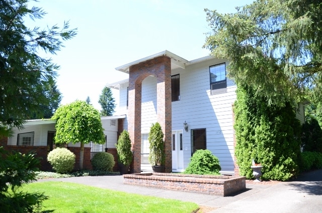
Property Record
1712 Nw 149Th St, Vancouver, WA 98685


NEARBY LISTINGS FOR SALE OR LEASE
-
-
View all Vancouver listings for sale on LoopNet.com
Property Detail
1712 Nw 149Th St
Portland-Vancouver-Hillsboro, OR-WA
1-784
184967-015
LOT 4 SP 1-784 1.93 A FOR ASSESSOR USE ONLY LOT 4 SP 1-784 1.93 A
Retirementnursinghomecombined
Clark
X
Washington
53011C0352D
4
2025
1.93 AC
2025
Hazel Dell/Salmon Creek
040905
Portland
5,429 SF
DEMOGRAPHICS near 1712 Nw 149Th St
1 Mile
3 Mile
5 Mile
2024 Total Population
5,611
50,541
97,903
2029 Population
6,002
54,275
105,384
Pop Growth 2024-2029
+ 6.97%
+ 7.39%
+ 7.64%
Average Age
43
43
42
2024 Total Households
2,112
19,084
36,993
HH Growth 2024-2029
+ 7.10%
+ 7.61%
+ 7.79%
Median Household Inc
$105,765
$103,229
$93,928
Avg Household Size
2.60
2.60
2.60
2024 Avg HH Vehicles
2.00
2.00
2.00
Median Home Value
$492,307
$493,886
$485,687
Median Year Built
1992
1990
1991
Nearby Places
Map Layers
Map Styles
 Street
 Aerial
- Restaurants
- Banks
- Shops
- Fitness
- Groceries
PUBLIC TRANSPORTATION
COMMUTER RAIL
DRIVE
WALK
Distance
18 min
9.7 mi
AIRPORT
Portland International
DRIVE
WALK
Distance
Portland International
27 min
17.1 mi
Freight Ports
Port of Vancouver
DRIVE
WALK
Distance
Port of Vancouver
19 min
8.2 mi
Nearby Properties
Address
Land Use
TOTAL SIZE
Lot Size
Zoning
Address
Land Use
TOTAL SIZE
Lot Size
Zoning
494,738 SF
7.33 AC
GC
Address
Land Use
TOTAL SIZE
Lot Size
Zoning
540,669 SF
272.10 AC
U
Address
Land Use
TOTAL SIZE
Lot Size
Zoning
335,784 SF
12.93 AC
GC
Address
Land Use
TOTAL SIZE
Lot Size
Zoning
262,710 SF
14.99 AC
R-22
Address
Land Use
TOTAL SIZE
Lot Size
Zoning
211,613 SF
28.21 AC
R1-6
Address
Land Use
TOTAL SIZE
Lot Size
Zoning
275,000 SF
67.54 AC
R1-7.5
Address
Land Use
TOTAL SIZE
Lot Size
Zoning
173,174 SF
7.18 AC
OR-22
Address
Land Use
TOTAL SIZE
Lot Size
Zoning
143,094 SF
6.42 AC
OR-30
Address
Land Use
TOTAL SIZE
Lot Size
Zoning
477,314 SF
57.47 AC
PF
Address
Land Use
TOTAL SIZE
Lot Size
Zoning
357,176 SF
9.82 AC
R-22
Address
Land Use
TOTAL SIZE
Lot Size
Zoning
185,080 SF
14.49 AC
R-30
Address
Land Use
TOTAL SIZE
Lot Size
Zoning
93,616 SF
41.61 AC
PF
Address
Land Use
TOTAL SIZE
Lot Size
Zoning
197,650 SF
35.36 AC
R1-7.5
Address
Land Use
TOTAL SIZE
Lot Size
Zoning
146,302 SF
3.33 AC
GC
Address
Land Use
TOTAL SIZE
Lot Size
Zoning
141,175 SF
9.83 AC
R-18
Address
Land Use
TOTAL SIZE
Lot Size
Zoning
277,402 SF
5.57 AC
R-43
Address
Land Use
TOTAL SIZE
Lot Size
Zoning
91,328 SF
7.38 AC
GC
Address
Land Use
TOTAL SIZE
Lot Size
Zoning
244,012 SF
2.83 AC
R-18
Address
Land Use
TOTAL SIZE
Lot Size
Zoning
163,716 SF
4.55 AC
R-12
Address
Land Use
TOTAL SIZE
Lot Size
Zoning
80,038 SF
3.78 AC
CC
Address
Land Use
TOTAL SIZE
Lot Size
Zoning
142,316 SF
4.01 AC
OR-30
Address
Land Use
TOTAL SIZE
Lot Size
Zoning
111,296 SF
7.23 AC
R-30
Address
Land Use
TOTAL SIZE
Lot Size
Zoning
94,008 SF
4.78 AC
R-30
Address
Land Use
TOTAL SIZE
Lot Size
Zoning
166,620 SF
14.85 AC
CC
Address
Land Use
TOTAL SIZE
Lot Size
Zoning
94,060 SF
3.19 AC
OR-30
Address
Land Use
TOTAL SIZE
Lot Size
Zoning
107,881 SF
5.19 AC
R-22
Address
Land Use
TOTAL SIZE
Lot Size
Zoning
64,141 SF
8.18 AC
R1-6
Address
Land Use
TOTAL SIZE
Lot Size
Zoning
80,843 SF
8.17 AC
GC
Address
Land Use
TOTAL SIZE
Lot Size
Zoning
87,654 SF
0.92 AC
CC
The World's #1 Commercial Real Estate Marketplace
Connect with us
© 2026 CoStar Group
The information above has been obtained from sources believed reliable. While we do not doubt its accuracy we have not verified it and make no guarantee, warranty or representation about it. It is your responsibility to independently confirm its accuracy and completeness. Any projections, opinions, assumptions, or estimates used are for example only and do not represent the current or future performance of the property. The value of this transaction to you depends on tax and other factors which should be evaluated by your tax, financial, and legal advisors. You and your advisors should conduct a careful, independent investigation of the property to determine to your satisfaction the suitability of the property for your needs.