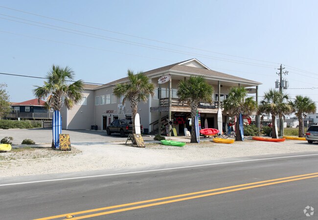
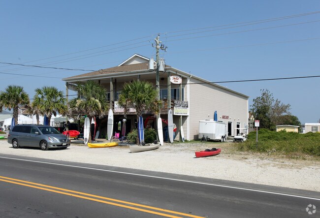
Property Record
1713 N New River Dr, Surf City, NC 28445

NEARBY LISTINGS FOR SALE OR LEASE
Property Detail
1713 N New River Dr
Jacksonville, NC
Junior Johnson Inc
001768
L1 & L2 S3 B36 OLD SETTLERS BEACH
Bartavern
Onslow
VE
North Carolina
3720424500L
1
2025
0.33 AC
2025
Coastal Carolina
000403
Other Market Areas
8,212 SF
DEMOGRAPHICS near 1713 N New River Dr
1 Mile
3 Mile
5 Mile
2024 Total Population
1,447
5,654
15,660
2029 Population
1,756
6,860
18,408
Pop Growth 2024-2029
+ 21.35%
+ 21.33%
+ 17.55%
Average Age
51
44
41
2024 Total Households
737
2,569
6,569
HH Growth 2024-2029
+ 21.30%
+ 21.68%
+ 18.16%
Median Household Inc
$72,075
$72,852
$72,200
Avg Household Size
2.00
2.20
2.40
2024 Avg HH Vehicles
2.00
2.00
2.00
Median Home Value
$456,722
$333,064
$289,469
Median Year Built
1994
1997
2000
Nearby Places
Map Layers
Map Styles
 Street
 Aerial
- Restaurants
- Banks
- Shops
- Fitness
- Groceries
PUBLIC TRANSPORTATION
AIRPORT
Wilmington International
DRIVE
WALK
Distance
Wilmington International
47 min
33.7 mi
Freight Ports
Port of Wilmington
DRIVE
WALK
Distance
Port of Wilmington
1 min
30.1 mi
SALE & LEASE HISTORY
LISTING DATE
SALE/LEASE

Oct 25, 2016
For Sale
May 11, 2017
For Sale
Mar 31, 2017
For Sale
Nearby Properties
Address
Land Use
TOTAL SIZE
Lot Size
Zoning
Address
Land Use
TOTAL SIZE
Lot Size
Zoning
47,280 SF
20 AC
Address
Land Use
TOTAL SIZE
Lot Size
Zoning
42,092 SF
6.23 AC
SEEMAP
Address
Land Use
TOTAL SIZE
Lot Size
Zoning
1,213.25 AC
R-15
Address
Land Use
TOTAL SIZE
Lot Size
Zoning
27,948 SF
3.13 AC
B2
Address
Land Use
TOTAL SIZE
Lot Size
Zoning
36,000 SF
4.64 AC
B2RA
Address
Land Use
TOTAL SIZE
Lot Size
Zoning
46,080 SF
7.41 AC
Address
Land Use
TOTAL SIZE
Lot Size
Zoning
4.02 AC
R5
Address
Land Use
TOTAL SIZE
Lot Size
Zoning
8,644 SF
3.10 AC
C1
Address
Land Use
TOTAL SIZE
Lot Size
Zoning
34,996 SF
5.86 AC
SEEMAP
Address
Land Use
TOTAL SIZE
Lot Size
Zoning
900 SF
4.74 AC
C1
Address
Land Use
TOTAL SIZE
Lot Size
Zoning
13,606 SF
1.52 AC
SEEMAP
Address
Land Use
TOTAL SIZE
Lot Size
Zoning
15,360 SF
0.95 AC
C2
Address
Land Use
TOTAL SIZE
Lot Size
Zoning
2,035 SF
0.21 AC
Address
Land Use
TOTAL SIZE
Lot Size
Zoning
8,990 SF
1.10 AC
C1
Address
Land Use
TOTAL SIZE
Lot Size
Zoning
1,420 SF
23.59 AC
PD
Address
Land Use
TOTAL SIZE
Lot Size
Zoning
13,482 SF
3.99 AC
SEEMAP
Address
Land Use
TOTAL SIZE
Lot Size
Zoning
8,000 SF
16.40 AC
R-15
Address
Land Use
TOTAL SIZE
Lot Size
Zoning
9,949 SF
1.14 AC
C2
Address
Land Use
TOTAL SIZE
Lot Size
Zoning
9,237 SF
2.17 AC
SEEMAP
Address
Land Use
TOTAL SIZE
Lot Size
Zoning
2,400 SF
1.78 AC
PD
Address
Land Use
TOTAL SIZE
Lot Size
Zoning
8,808 SF
0.95 AC
B2
Address
Land Use
TOTAL SIZE
Lot Size
Zoning
2,800 SF
4.74 AC
SEEMAP
Address
Land Use
TOTAL SIZE
Lot Size
Zoning
13,572 SF
0.65 AC
C1
Address
Land Use
TOTAL SIZE
Lot Size
Zoning
4,498 SF
1.21 AC
SEEMAP
Address
Land Use
TOTAL SIZE
Lot Size
Zoning
12,745 SF
1.38 AC
Address
Land Use
TOTAL SIZE
Lot Size
Zoning
1.10 AC
C2
Address
Land Use
TOTAL SIZE
Lot Size
Zoning
7,316 SF
0.53 AC
C1
Address
Land Use
TOTAL SIZE
Lot Size
Zoning
10,585 SF
1.16 AC
SEEMAP
Address
Land Use
TOTAL SIZE
Lot Size
Zoning
13,602 SF
0.92 AC
C1
Address
Land Use
TOTAL SIZE
Lot Size
Zoning
12,000 SF
1.52 AC
SEEMAP
The World's #1 Commercial Real Estate Marketplace
Connect with us
© 2026 CoStar Group
The information above has been obtained from sources believed reliable. While we do not doubt its accuracy we have not verified it and make no guarantee, warranty or representation about it. It is your responsibility to independently confirm its accuracy and completeness. Any projections, opinions, assumptions, or estimates used are for example only and do not represent the current or future performance of the property. The value of this transaction to you depends on tax and other factors which should be evaluated by your tax, financial, and legal advisors. You and your advisors should conduct a careful, independent investigation of the property to determine to your satisfaction the suitability of the property for your needs.