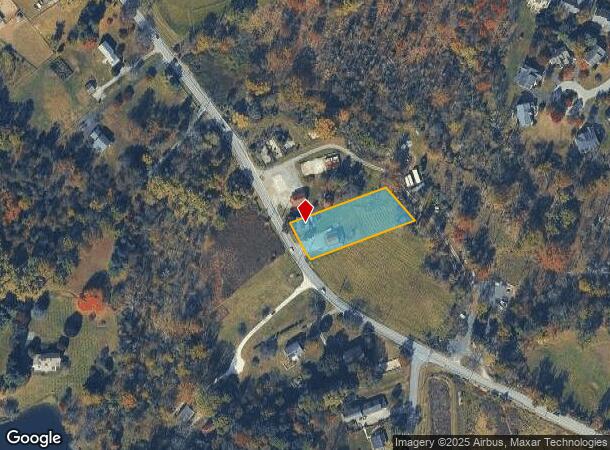
Property Record
1719 Conestoga Rd, Chester Springs, PA 19425
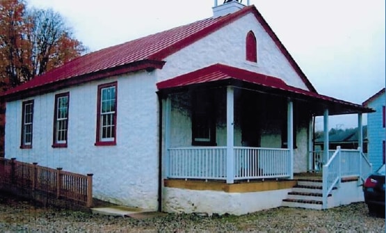
This Property Is For Sale
NEARBY LISTINGS FOR SALE OR LEASE
Property Detail
1719 Conestoga Rd
Philadelphia-Camden-Wilmington, PA-NJ-DE-MD
Chester
34-004-0016.0000
Pennsylvania
Sfr
1 AC
AE
Exton/Whitelands
42029C0095G
Philadelphia
2,028 SF
DEMOGRAPHICS near 1719 Conestoga Rd
1 Mile
3 Mile
5 Mile
2024 Total Population
2,045
26,609
72,775
2029 Population
2,125
27,924
76,613
Pop Growth 2024-2029
+ 3.91%
+ 4.94%
+ 5.27%
Average Age
43
40
40
2024 Total Households
723
9,526
26,434
HH Growth 2024-2029
+ 4.01%
+ 5.18%
+ 5.44%
Median Household Inc
$219,701
$140,231
$143,383
Avg Household Size
2.80
2.80
2.70
2024 Avg HH Vehicles
2.00
2.00
2.00
Median Home Value
$646,033
$504,544
$476,366
Median Year Built
1992
1994
1991
Nearby Places
- Restaurants
- Banks
- Shops
- Fitness
- Groceries
PUBLIC TRANSPORTATION
COMMUTER RAIL
Whitford (R5 - Southeastern Pennsylvania Transportation Authority Regional Rail (SEPTA Regional Rail))
DRIVE
WALK
Distance
Whitford (R5 - Southeastern Pennsylvania Transportation Authority Regional Rail (SEPTA Regional Rail))
13 min
6.1 mi
Exton (R5 - Southeastern Pennsylvania Transportation Authority Regional Rail (SEPTA Regional Rail))
DRIVE
WALK
Distance
Exton (R5 - Southeastern Pennsylvania Transportation Authority Regional Rail (SEPTA Regional Rail))
12 min
6.3 mi
AIRPORT
Philadelphia International
DRIVE
WALK
Distance
Philadelphia International
56 min
35.2 mi
Freight Ports
Port of Wilmington, RI
DRIVE
WALK
Distance
Port of Wilmington, RI
53 min
30.6 mi
Nearby Properties
Address
Land Use
TOTAL SIZE
Lot Size
Zoning
Address
Land Use
TOTAL SIZE
Lot Size
Zoning
567,795 SF
4.07 AC
TCM
Address
Land Use
TOTAL SIZE
Lot Size
Zoning
434,360 SF
37.50 AC
R2
Address
Land Use
TOTAL SIZE
Lot Size
Zoning
282,364 SF
34.80 AC
R1
Address
Land Use
TOTAL SIZE
Lot Size
Zoning
313,166 SF
4.36 AC
RA
Address
Land Use
TOTAL SIZE
Lot Size
Zoning
440,731 SF
41.15 AC
RA
Address
Land Use
TOTAL SIZE
Lot Size
Zoning
449,617 SF
36.60 AC
R2
Address
Land Use
TOTAL SIZE
Lot Size
Zoning
210,211 SF
18.51 AC
R2
Address
Land Use
TOTAL SIZE
Lot Size
Zoning
253,570 SF
12.21 AC
L1
Address
Land Use
TOTAL SIZE
Lot Size
Zoning
249,644 SF
22.58 AC
R1
Address
Land Use
TOTAL SIZE
Lot Size
Zoning
136,114 SF
12.20 AC
R1
Address
Land Use
TOTAL SIZE
Lot Size
Zoning
171,609 SF
21.10 AC
RA
Address
Land Use
TOTAL SIZE
Lot Size
Zoning
8.67 AC
RA
Address
Land Use
TOTAL SIZE
Lot Size
Zoning
149,289 SF
8.63 AC
R2
Address
Land Use
TOTAL SIZE
Lot Size
Zoning
158,574 SF
12.01 AC
RA
Address
Land Use
TOTAL SIZE
Lot Size
Zoning
203,450 SF
27.18 AC
R2
Address
Land Use
TOTAL SIZE
Lot Size
Zoning
85,372 SF
11.20 AC
R1
Address
Land Use
TOTAL SIZE
Lot Size
Zoning
108,215 SF
6.50 AC
I1
Address
Land Use
TOTAL SIZE
Lot Size
Zoning
87,400 SF
18.10 AC
C1
Address
Land Use
TOTAL SIZE
Lot Size
Zoning
101,894 SF
14.15 AC
C1
Address
Land Use
TOTAL SIZE
Lot Size
Zoning
126,842 SF
13.50 AC
PC
Address
Land Use
TOTAL SIZE
Lot Size
Zoning
146,363 SF
21.32 AC
PC
Address
Land Use
TOTAL SIZE
Lot Size
Zoning
87,922 SF
12.30 AC
PC
Address
Land Use
TOTAL SIZE
Lot Size
Zoning
86,901 SF
0.61 AC
PCID
Address
Land Use
TOTAL SIZE
Lot Size
Zoning
107,160 SF
0.82 AC
PCID
Address
Land Use
TOTAL SIZE
Lot Size
Zoning
119,408 SF
11.69 AC
RA
Address
Land Use
TOTAL SIZE
Lot Size
Zoning
125,664 SF
13.09 AC
RA
Address
Land Use
TOTAL SIZE
Lot Size
Zoning
94,661 SF
9.40 AC
RA
Address
Land Use
TOTAL SIZE
Lot Size
Zoning
272,135 SF
26.63 AC
R2
Address
Land Use
TOTAL SIZE
Lot Size
Zoning
69,435 SF
41.90 AC
CR
Address
Land Use
TOTAL SIZE
Lot Size
Zoning
130,670 SF
8.50 AC
PI
The World's #1 Commercial Real Estate Marketplace
Connect with us
© 2025 CoStar Group
The information above has been obtained from sources believed reliable. While we do not doubt its accuracy we have not verified it and make no guarantee, warranty or representation about it. It is your responsibility to independently confirm its accuracy and completeness. Any projections, opinions, assumptions, or estimates used are for example only and do not represent the current or future performance of the property. The value of this transaction to you depends on tax and other factors which should be evaluated by your tax, financial, and legal advisors. You and your advisors should conduct a careful, independent investigation of the property to determine to your satisfaction the suitability of the property for your needs.