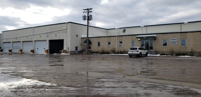
Property Record
1715 Dixie Rd, Neenah, WI 54956

Property Detail
1715 Dixie Rd
Oshkosh-Neenah, WI
PT N1/2 NE1/4 DESC AS LOT 2 OF CSM-2264 4.67 A.
010-01300201
Winnebago
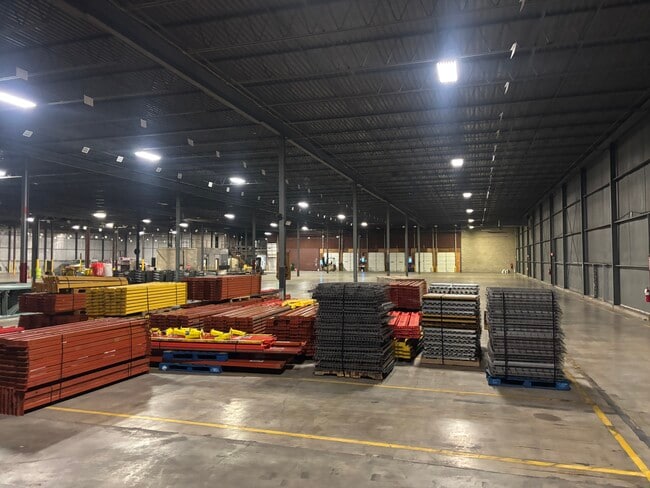
Commercialnec
Wisconsin
M2
2
B and X Area of moderate flood hazard, usually the area between the limits of the 100-year and 500-year floods.
4.67 AC
2024
Appleton/Oshkosh
2025
Other Market Areas
003704
NEARBY LISTINGS FOR SALE OR LEASE
DEMOGRAPHICS near 1715 Dixie Rd
1 mile
3 mile
5 mile
2025 Total Population
539
23,992
41,812
2030 Population
539
24,161
42,267
Pop Growth 2025-2030
0.00%
+ 0.70%
+ 1.09%
Average Age
42
41
41
2025 Total Households
221
10,036
17,519
HH Growth 2025-2030
(0.45%)
+ 0.68%
+ 1.06%
Median Household Inc
$106,048
$79,487
$76,132
Avg Household Size
2.40
2.30
2.30
2025 Avg HH Vehicles
2.00
2.00
2.00
Median Home Value
$324,561
$253,394
$237,360
Median Year Built
1996
1976
1971
Nearby Places
Map Layers
Map Styles
 Street
 Aerial
Layers
 Traffic
 Biking
Places
Listings with unknown addresses are not visible on the map
- Restaurants
- Banks
- Shops
- Fitness
- Groceries
PUBLIC TRANSPORTATION
AIRPORT
Appleton International
Drive
Walk
Distance
Appleton International
22 min
11.8 mi
Green Bay/Austin Straubel International
Drive
Walk
Distance
Green Bay/Austin Straubel International
52 min
39.6 mi
Freight Ports
Port Milwaukee
Drive
Walk
Distance
Port Milwaukee
121 min
100.4 mi
SALE & LEASE HISTORY
LISTING DATE
SALE/LEASE

Jan 31, 2020
For Sale
Jan 31, 2020
For Lease
Jan 22, 2026
For Lease
Apr 12, 2024
For Lease
Nearby Properties
Address
Land Use
TOTAL SIZE
Lot Size
Zoning
Address
Land Use
TOTAL SIZE
Lot Size
Zoning
1,975 SF
2.40 AC
M2
Address
Land Use
TOTAL SIZE
Lot Size
Zoning
Address
Land Use
TOTAL SIZE
Lot Size
Zoning
800 SF
19.84 AC
I1
Address
Land Use
TOTAL SIZE
Lot Size
Zoning
59,584 SF
12.11 AC
C1
Address
Land Use
TOTAL SIZE
Lot Size
Zoning
29.32 AC
I1
Address
Land Use
TOTAL SIZE
Lot Size
Zoning
67.41 AC
I2
Address
Land Use
TOTAL SIZE
Lot Size
Zoning
210,214 SF
16.44 AC
I1
Address
Land Use
TOTAL SIZE
Lot Size
Zoning
361,899 SF
18.54 AC
I2
Address
Land Use
TOTAL SIZE
Lot Size
Zoning
115,151 SF
11.71 AC
PDD
Address
Land Use
TOTAL SIZE
Lot Size
Zoning
139,871 SF
11.14 AC
C1
Address
Land Use
TOTAL SIZE
Lot Size
Zoning
74,603 SF
4.96 AC
I1
Address
Land Use
TOTAL SIZE
Lot Size
Zoning
145,322 SF
11.20 AC
PDD
Address
Land Use
TOTAL SIZE
Lot Size
Zoning
92,039 SF
13.55 AC
I2
Address
Land Use
TOTAL SIZE
Lot Size
Zoning
9.27 AC
I1
Address
Land Use
TOTAL SIZE
Lot Size
Zoning
92,030 SF
7.79 AC
I1
Address
Land Use
TOTAL SIZE
Lot Size
Zoning
48,933 SF
2.80 AC
PDD
Address
Land Use
TOTAL SIZE
Lot Size
Zoning
22.72 AC
I1
Address
Land Use
TOTAL SIZE
Lot Size
Zoning
6.61 AC
I2
Address
Land Use
TOTAL SIZE
Lot Size
Zoning
37,672 SF
5.26 AC
PDD
Address
Land Use
TOTAL SIZE
Lot Size
Zoning
117,640 SF
7.45 AC
I1
Address
Land Use
TOTAL SIZE
Lot Size
Zoning
160,920 SF
7.89 AC
M2
Address
Land Use
TOTAL SIZE
Lot Size
Zoning
160,920 SF
7.98 AC
M2
Address
Land Use
TOTAL SIZE
Lot Size
Zoning
107,703 SF
4.63 AC
I2
Address
Land Use
TOTAL SIZE
Lot Size
Zoning
253,191 SF
18.75 AC
I2
Address
Land Use
TOTAL SIZE
Lot Size
Zoning
50,652 SF
8.51 AC
C1
Address
Land Use
TOTAL SIZE
Lot Size
Zoning
12,920 SF
4.96 AC
M2
Address
Land Use
TOTAL SIZE
Lot Size
Zoning
192,120 SF
11.41 AC
I1
Address
Land Use
TOTAL SIZE
Lot Size
Zoning
11.20 AC
Address
Land Use
TOTAL SIZE
Lot Size
Zoning
57,721 SF
7.51 AC
PDD
Address
Land Use
TOTAL SIZE
Lot Size
Zoning
37,378 SF
4.15 AC
M1
The World's #1 Commercial Real Estate Marketplace
Connect with us
© 2026 CoStar Group
The information above has been obtained from sources believed reliable. While we do not doubt its accuracy we have not verified it and make no guarantee, warranty or representation about it. It is your responsibility to independently confirm its accuracy and completeness. Any projections, opinions, assumptions, or estimates used are for example only and do not represent the current or future performance of the property. The value of this transaction to you depends on tax and other factors which should be evaluated by your tax, financial, and legal advisors. You and your advisors should conduct a careful, independent investigation of the property to determine to your satisfaction the suitability of the property for your needs.