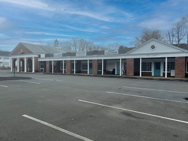
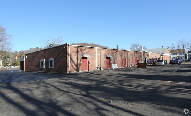
Property Record
1715 Foxon Rd, North Branford, CT 06471

NEARBY LISTINGS FOR SALE OR LEASE
Property Detail
1715 Foxon Rd
Commercialbuilding
New Haven
AE
Connecticut
09009C0459J
2.41 AC
2025
Branford
2025
Westchester/So Connecticut
186100
New Haven-Milford, CT
10,826 SF
NBRA-000019A-000000-000003
DEMOGRAPHICS near 1715 Foxon Rd
1 Mile
3 Mile
5 Mile
2024 Total Population
2,497
16,104
58,169
2029 Population
2,508
16,140
58,208
Pop Growth 2024-2029
+ 0.44%
+ 0.22%
+ 0.07%
Average Age
46
45
45
2024 Total Households
1,105
6,505
24,022
HH Growth 2024-2029
+ 0.63%
+ 0.22%
+ 0.01%
Median Household Inc
$83,904
$111,405
$102,957
Avg Household Size
2.20
2.40
2.40
2024 Avg HH Vehicles
2.00
2.00
2.00
Median Home Value
$316,368
$362,400
$353,690
Median Year Built
1977
1975
1974
Nearby Places
Map Layers
Map Styles
 Street
 Aerial
- Restaurants
- Banks
- Shops
- Fitness
- Groceries
PUBLIC TRANSPORTATION
COMMUTER RAIL
Branford (Commuter Rail - Shore Line East, Shore Line East - Shore Line East)
DRIVE
WALK
Distance
Branford (Commuter Rail - Shore Line East, Shore Line East - Shore Line East)
11 min
5.5 mi
Guilford (Shore Line East - Shore Line East)
DRIVE
WALK
Distance
Guilford (Shore Line East - Shore Line East)
13 min
6.9 mi
AIRPORT
Tweed/New Haven
DRIVE
WALK
Distance
Tweed/New Haven
17 min
9.3 mi
Freight Ports
Port of New Haven
DRIVE
WALK
Distance
Port of New Haven
16 min
9.0 mi
SALE & LEASE HISTORY
LISTING DATE
SALE/LEASE

Jul 23, 2018
For Lease
Dec 21, 2016
For Lease
Nearby Properties
Address
Land Use
TOTAL SIZE
Lot Size
Zoning
Address
Land Use
TOTAL SIZE
Lot Size
Zoning
30 AC
R-5
Address
Land Use
TOTAL SIZE
Lot Size
Zoning
50.70 AC
R40
Address
Land Use
TOTAL SIZE
Lot Size
Zoning
88.66 AC
I3
Address
Land Use
TOTAL SIZE
Lot Size
Zoning
2,295.68 AC
R80
Address
Land Use
TOTAL SIZE
Lot Size
Zoning
7,065 SF
9.44 AC
Address
Land Use
TOTAL SIZE
Lot Size
Zoning
70,417 SF
7 AC
R40
Address
Land Use
TOTAL SIZE
Lot Size
Zoning
10.30 AC
B1
Address
Land Use
TOTAL SIZE
Lot Size
Zoning
8.29 AC
Address
Land Use
TOTAL SIZE
Lot Size
Zoning
142,136 SF
58.31 AC
R-8
Address
Land Use
TOTAL SIZE
Lot Size
Zoning
79,294 SF
44 AC
R-5
Address
Land Use
TOTAL SIZE
Lot Size
Zoning
2,196 SF
1.68 AC
PRB3
Address
Land Use
TOTAL SIZE
Lot Size
Zoning
Address
Land Use
TOTAL SIZE
Lot Size
Zoning
13.90 AC
Address
Land Use
TOTAL SIZE
Lot Size
Zoning
54,799 SF
4.06 AC
Address
Land Use
TOTAL SIZE
Lot Size
Zoning
15.10 AC
Address
Land Use
TOTAL SIZE
Lot Size
Zoning
7.69 AC
RU1
Address
Land Use
TOTAL SIZE
Lot Size
Zoning
29.40 AC
Address
Land Use
TOTAL SIZE
Lot Size
Zoning
5,440 SF
12.44 AC
RGA
Address
Land Use
TOTAL SIZE
Lot Size
Zoning
49,215 SF
2.09 AC
Address
Land Use
TOTAL SIZE
Lot Size
Zoning
29.48 AC
I3
Address
Land Use
TOTAL SIZE
Lot Size
Zoning
695.83 AC
I1
Address
Land Use
TOTAL SIZE
Lot Size
Zoning
45,766 SF
7.71 AC
R-7
Address
Land Use
TOTAL SIZE
Lot Size
Zoning
58,910 SF
5.17 AC
Address
Land Use
TOTAL SIZE
Lot Size
Zoning
38,352 SF
24 AC
Address
Land Use
TOTAL SIZE
Lot Size
Zoning
86,508 SF
7.07 AC
Address
Land Use
TOTAL SIZE
Lot Size
Zoning
58,601 SF
3.29 AC
Address
Land Use
TOTAL SIZE
Lot Size
Zoning
35,132 SF
2.89 AC
Address
Land Use
TOTAL SIZE
Lot Size
Zoning
Address
Land Use
TOTAL SIZE
Lot Size
Zoning
36,856 SF
3.10 AC
Address
Land Use
TOTAL SIZE
Lot Size
Zoning
The World's #1 Commercial Real Estate Marketplace
Connect with us
© 2025 CoStar Group
The information above has been obtained from sources believed reliable. While we do not doubt its accuracy we have not verified it and make no guarantee, warranty or representation about it. It is your responsibility to independently confirm its accuracy and completeness. Any projections, opinions, assumptions, or estimates used are for example only and do not represent the current or future performance of the property. The value of this transaction to you depends on tax and other factors which should be evaluated by your tax, financial, and legal advisors. You and your advisors should conduct a careful, independent investigation of the property to determine to your satisfaction the suitability of the property for your needs.