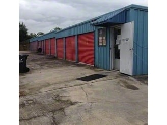
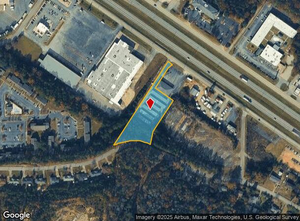
Property Record
1715 Highway 280 Byp, Phenix City, AL 36867

NEARBY LISTINGS FOR SALE OR LEASE
Property Detail
1715 Highway 280 Byp
Columbus, GA-AL
S15T17R30 LOT B2 REPLAT PT SEC 15 (G 100)
05-05-15-03-002-003.003
Russell
Realpropertynec
Alabama
X
b2
01113C0159C
2 AC
2024
Phenix City
2024
Columbus GA
030700
DEMOGRAPHICS near 1715 Highway 280 Byp
1 Mile
3 Mile
5 Mile
2024 Total Population
6,100
37,806
108,538
2029 Population
6,014
37,568
108,986
Pop Growth 2024-2029
(1.41%)
(0.63%)
+ 0.41%
Average Age
36
37
38
2024 Total Households
2,468
16,296
44,997
HH Growth 2024-2029
(1.38%)
(0.53%)
+ 0.29%
Median Household Inc
$29,380
$31,849
$38,759
Avg Household Size
2.40
2.20
2.30
2024 Avg HH Vehicles
2.00
1.00
1.00
Median Home Value
$130,829
$136,300
$141,622
Median Year Built
1978
1974
1971
Nearby Places
Map Layers
Map Styles
 Street
 Aerial
- Restaurants
- Banks
- Shops
- Fitness
- Groceries
PUBLIC TRANSPORTATION
AIRPORT
Columbus
DRIVE
WALK
Distance
Columbus
17 min
9.6 mi
Freight Ports
Port of Panama City
DRIVE
WALK
Distance
Port of Panama City
229 min
182.3 mi
SALE & LEASE HISTORY
LISTING DATE
SALE/LEASE

Nov 01, 2017
For Sale
Jul 13, 2021
For Sale
Nearby Properties
Address
Land Use
TOTAL SIZE
Lot Size
Zoning
Address
Land Use
TOTAL SIZE
Lot Size
Zoning
68,000 SF
11.21 AC
Address
Land Use
TOTAL SIZE
Lot Size
Zoning
32,750 SF
4.01 AC
Address
Land Use
TOTAL SIZE
Lot Size
Zoning
2.48 AC
Address
Land Use
TOTAL SIZE
Lot Size
Zoning
43,888 SF
2 AC
Address
Land Use
TOTAL SIZE
Lot Size
Zoning
216,360 SF
17.51 AC
Address
Land Use
TOTAL SIZE
Lot Size
Zoning
65,875 SF
2.37 AC
Address
Land Use
TOTAL SIZE
Lot Size
Zoning
63,220 SF
3.49 AC
Address
Land Use
TOTAL SIZE
Lot Size
Zoning
2.31 AC
Address
Land Use
TOTAL SIZE
Lot Size
Zoning
10,705 SF
0.64 AC
Address
Land Use
TOTAL SIZE
Lot Size
Zoning
31,847 SF
1.21 AC
Address
Land Use
TOTAL SIZE
Lot Size
Zoning
4,334 SF
13.29 AC
Address
Land Use
TOTAL SIZE
Lot Size
Zoning
1.21 AC
Address
Land Use
TOTAL SIZE
Lot Size
Zoning
34,866 SF
2.34 AC
Address
Land Use
TOTAL SIZE
Lot Size
Zoning
18,050 SF
1.17 AC
Address
Land Use
TOTAL SIZE
Lot Size
Zoning
29,640 SF
1.11 AC
Address
Land Use
TOTAL SIZE
Lot Size
Zoning
Address
Land Use
TOTAL SIZE
Lot Size
Zoning
83,295 SF
17.87 AC
Address
Land Use
TOTAL SIZE
Lot Size
Zoning
72,200 SF
5.52 AC
Address
Land Use
TOTAL SIZE
Lot Size
Zoning
17,000 SF
6 AC
O
Address
Land Use
TOTAL SIZE
Lot Size
Zoning
56,775 SF
4.26 AC
Address
Land Use
TOTAL SIZE
Lot Size
Zoning
41,084 SF
5.58 AC
Address
Land Use
TOTAL SIZE
Lot Size
Zoning
8,888 SF
10 AC
O
Address
Land Use
TOTAL SIZE
Lot Size
Zoning
68,746 SF
4.32 AC
Address
Land Use
TOTAL SIZE
Lot Size
Zoning
32,687 SF
16.31 AC
Address
Land Use
TOTAL SIZE
Lot Size
Zoning
29,393 SF
1.40 AC
Address
Land Use
TOTAL SIZE
Lot Size
Zoning
103,384 SF
4.05 AC
Address
Land Use
TOTAL SIZE
Lot Size
Zoning
19.99 AC
Address
Land Use
TOTAL SIZE
Lot Size
Zoning
22,332 SF
0.51 AC
Address
Land Use
TOTAL SIZE
Lot Size
Zoning
26,371 SF
2.14 AC
The World's #1 Commercial Real Estate Marketplace
Connect with us
© 2025 CoStar Group
The information above has been obtained from sources believed reliable. While we do not doubt its accuracy we have not verified it and make no guarantee, warranty or representation about it. It is your responsibility to independently confirm its accuracy and completeness. Any projections, opinions, assumptions, or estimates used are for example only and do not represent the current or future performance of the property. The value of this transaction to you depends on tax and other factors which should be evaluated by your tax, financial, and legal advisors. You and your advisors should conduct a careful, independent investigation of the property to determine to your satisfaction the suitability of the property for your needs.