Property Record
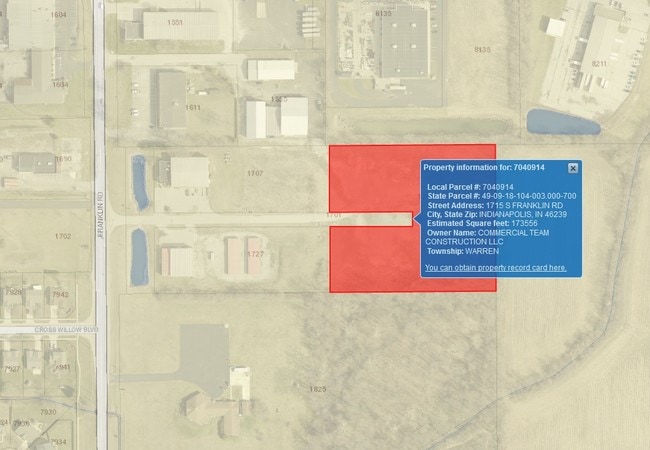
1715 S Franklin Rd, Indianapolis, IN 46239


NEARBY LISTINGS FOR SALE OR LEASE
Property Detail
1715 S Franklin Rd
Indianapolis-Carmel-Anderson, IN
PT NW1/4 SW1/4 S18 T15 R5 BEG 628.17 E OF NW CORE 454.58 S 402.78 W 454.58 N 181.39E 227.29 N 40 W 227.29 N 181.39 TO BEG 3.995 AC
49-09-18-104-003.000-700
Marion
Warehouse
Indiana
2023
3.99 AC
2024
Beech Grove/SE County
361401
Indianapolis
24,000 SF
DEMOGRAPHICS near 1715 S Franklin Rd
1 Mile
3 Mile
5 Mile
2024 Total Population
4,136
40,452
159,979
2029 Population
4,040
39,788
158,296
Pop Growth 2024-2029
(2.32%)
(1.64%)
(1.05%)
Average Age
35
38
38
2024 Total Households
1,518
15,422
62,802
HH Growth 2024-2029
(2.37%)
(1.68%)
(1.11%)
Median Household Inc
$55,622
$68,942
$59,416
Avg Household Size
2.70
2.60
2.50
2024 Avg HH Vehicles
2.00
2.00
2.00
Median Home Value
$212,088
$184,986
$168,895
Median Year Built
1997
1971
1966
Nearby Places
Map Layers
Map Styles
 Street
 Aerial
- Restaurants
- Banks
- Shops
- Fitness
- Groceries
PUBLIC TRANSPORTATION
COMMUTER RAIL
Indianapolis (Cardinal - Amtrak)
DRIVE
WALK
Distance
Indianapolis (Cardinal - Amtrak)
15 min
7.8 mi
AIRPORT
Indianapolis International
DRIVE
WALK
Distance
Indianapolis International
36 min
19.8 mi
Freight Ports
Port of Toledo
DRIVE
WALK
Distance
Port of Toledo
267 min
225.0 mi
Nearby Properties
Address
Land Use
TOTAL SIZE
Lot Size
Zoning
Address
Land Use
TOTAL SIZE
Lot Size
Zoning
1,202,700 SF
77.25 AC
ZO01
Address
Land Use
TOTAL SIZE
Lot Size
Zoning
47.10 AC
ZO01
Address
Land Use
TOTAL SIZE
Lot Size
Zoning
584,250 SF
42.54 AC
ZO01
Address
Land Use
TOTAL SIZE
Lot Size
Zoning
9,888 SF
124.20 AC
ZO01
Address
Land Use
TOTAL SIZE
Lot Size
Zoning
3,902 SF
26.84 AC
ZO01
Address
Land Use
TOTAL SIZE
Lot Size
Zoning
768,000 SF
29.62 AC
ZO03
Address
Land Use
TOTAL SIZE
Lot Size
Zoning
405,664 SF
35.56 AC
ZO01
Address
Land Use
TOTAL SIZE
Lot Size
Zoning
3,132 SF
20.50 AC
Address
Land Use
TOTAL SIZE
Lot Size
Zoning
133,257 SF
93.03 AC
ZO01
Address
Land Use
TOTAL SIZE
Lot Size
Zoning
76,663 SF
1.91 AC
ZO01
Address
Land Use
TOTAL SIZE
Lot Size
Zoning
198,375 SF
24.52 AC
ZO01
Address
Land Use
TOTAL SIZE
Lot Size
Zoning
8,054 SF
20.62 AC
Address
Land Use
TOTAL SIZE
Lot Size
Zoning
5,560 SF
10.88 AC
ZO01
Address
Land Use
TOTAL SIZE
Lot Size
Zoning
1,575 SF
10.24 AC
Address
Land Use
TOTAL SIZE
Lot Size
Zoning
46,800 SF
49.64 AC
ZO01
Address
Land Use
TOTAL SIZE
Lot Size
Zoning
3,832 SF
12.77 AC
ZO01
Address
Land Use
TOTAL SIZE
Lot Size
Zoning
616,065 SF
51.20 AC
ZO01
Address
Land Use
TOTAL SIZE
Lot Size
Zoning
169,094 SF
10.43 AC
ZO01
Address
Land Use
TOTAL SIZE
Lot Size
Zoning
67,252 SF
7.50 AC
ZO01
Address
Land Use
TOTAL SIZE
Lot Size
Zoning
1,538 SF
14.49 AC
ZO01
Address
Land Use
TOTAL SIZE
Lot Size
Zoning
140,976 SF
15.46 AC
ZO01
Address
Land Use
TOTAL SIZE
Lot Size
Zoning
409,096 SF
26.01 AC
Address
Land Use
TOTAL SIZE
Lot Size
Zoning
113,863 SF
13.60 AC
Address
Land Use
TOTAL SIZE
Lot Size
Zoning
115,550 SF
11.58 AC
ZO01
Address
Land Use
TOTAL SIZE
Lot Size
Zoning
1,825,713 SF
147.81 AC
ZO01
Address
Land Use
TOTAL SIZE
Lot Size
Zoning
107,656 SF
7.66 AC
Address
Land Use
TOTAL SIZE
Lot Size
Zoning
160,410 SF
13.71 AC
Address
Land Use
TOTAL SIZE
Lot Size
Zoning
240,380 SF
44.81 AC
ZO01
Address
Land Use
TOTAL SIZE
Lot Size
Zoning
17,972 SF
4.48 AC
ZO01
Address
Land Use
TOTAL SIZE
Lot Size
Zoning
41,530 SF
2.78 AC
ZO01
The World's #1 Commercial Real Estate Marketplace
Connect with us
© 2025 CoStar Group
The information above has been obtained from sources believed reliable. While we do not doubt its accuracy we have not verified it and make no guarantee, warranty or representation about it. It is your responsibility to independently confirm its accuracy and completeness. Any projections, opinions, assumptions, or estimates used are for example only and do not represent the current or future performance of the property. The value of this transaction to you depends on tax and other factors which should be evaluated by your tax, financial, and legal advisors. You and your advisors should conduct a careful, independent investigation of the property to determine to your satisfaction the suitability of the property for your needs.