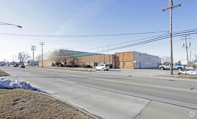
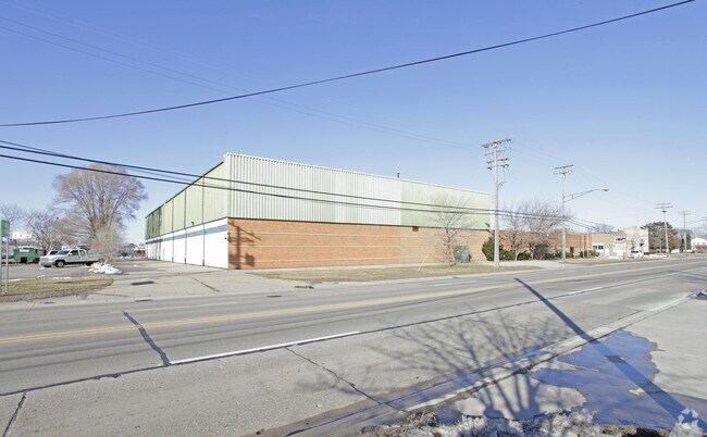
Property Record
17157 E 10 Mile Rd, Eastpointe, MI 48021


Property Detail
17157 E 10 Mile Rd
02-14-20-353-013
ASSESSOR'S PLAT NO. 30 LOTS 479, 480, 481 & 482 LIBER 38, PAGE 30
Lightindustrial
Macomb
I-1
Michigan
B and X Area of moderate flood hazard, usually the area between the limits of the 100-year and 500-year floods.
479-482
2025
1.63 AC
2025
Groesbeck South
258100
Detroit
50,866 SF
Detroit-Warren-Dearborn, MI
NEARBY LISTINGS FOR SALE OR LEASE
DEMOGRAPHICS near 17157 E 10 Mile Rd
1 mile
3 mile
5 mile
2025 Total Population
20,285
145,780
357,931
2030 Population
20,388
146,390
361,671
Pop Growth 2025-2030
+ 0.51%
+ 0.42%
+ 1.04%
Average Age
39
40
40
2025 Total Households
7,903
59,278
144,027
HH Growth 2025-2030
+ 0.49%
+ 0.44%
+ 1.01%
Median Household Inc
$60,408
$64,236
$60,678
Avg Household Size
2.50
2.40
2.40
2025 Avg HH Vehicles
2.00
2.00
2.00
Median Home Value
$130,423
$154,273
$164,615
Median Year Built
1956
1956
1957
Nearby Places
Map Layers
Map Styles
 Street
 Aerial
Transit
 Traffic
 Biking
Places
Listings with unknown addresses are not visible on the map
- Restaurants
- Banks
- Shops
- Fitness
- Groceries
PUBLIC TRANSPORTATION
AIRPORT
Windsor International
Drive
Walk
Distance
Windsor International
48 min
25.9 mi
Detroit Metro Wayne County
Drive
Walk
Distance
Detroit Metro Wayne County
51 min
35.4 mi
SALE & LEASE HISTORY
LISTING DATE
SALE/LEASE

Aug 17, 2020
For Sale
Nearby Properties
Address
Land Use
TOTAL SIZE
Lot Size
Zoning
Address
Land Use
TOTAL SIZE
Lot Size
Zoning
1,034,990 SF
28.60 AC
Address
Land Use
TOTAL SIZE
Lot Size
Zoning
260,164 SF
Address
Land Use
TOTAL SIZE
Lot Size
Zoning
238,144 SF
12.15 AC
MZ
Address
Land Use
TOTAL SIZE
Lot Size
Zoning
661,151 SF
37.28 AC
MZ
Address
Land Use
TOTAL SIZE
Lot Size
Zoning
323,858 SF
20.66 AC
R-3
Address
Land Use
TOTAL SIZE
Lot Size
Zoning
182,866 SF
5.08 AC
PD
Address
Land Use
TOTAL SIZE
Lot Size
Zoning
362,350 SF
22.39 AC
M-2
Address
Land Use
TOTAL SIZE
Lot Size
Zoning
89,970 SF
2.86 AC
RM-1
Address
Land Use
TOTAL SIZE
Lot Size
Zoning
162,597 SF
17.94 AC
C-2
Address
Land Use
TOTAL SIZE
Lot Size
Zoning
192,387 SF
11.26 AC
CLD
Address
Land Use
TOTAL SIZE
Lot Size
Zoning
204,620 SF
13.73 AC
R-3
Address
Land Use
TOTAL SIZE
Lot Size
Zoning
129,502 SF
3.17 AC
RM-1
Address
Land Use
TOTAL SIZE
Lot Size
Zoning
376,278 SF
19.85 AC
RM-1
Address
Land Use
TOTAL SIZE
Lot Size
Zoning
179,653 SF
11.56 AC
B-2
Address
Land Use
TOTAL SIZE
Lot Size
Zoning
103,069 SF
11.41 AC
B-3
Address
Land Use
TOTAL SIZE
Lot Size
Zoning
92,800 SF
6.71 AC
R-3
Address
Land Use
TOTAL SIZE
Lot Size
Zoning
105,354 SF
2.33 AC
B-3
Address
Land Use
TOTAL SIZE
Lot Size
Zoning
160,600 SF
9.62 AC
R-3
Address
Land Use
TOTAL SIZE
Lot Size
Zoning
228,269 SF
10.37 AC
I-2
Address
Land Use
TOTAL SIZE
Lot Size
Zoning
75,284 SF
0.87 AC
C
Address
Land Use
TOTAL SIZE
Lot Size
Zoning
167,589 SF
16.80 AC
B-3
Address
Land Use
TOTAL SIZE
Lot Size
Zoning
193,020 SF
13.62 AC
RM-1
Address
Land Use
TOTAL SIZE
Lot Size
Zoning
119,898 SF
14.65 AC
B-2
Address
Land Use
TOTAL SIZE
Lot Size
Zoning
133,611 SF
11.74 AC
B-3
Address
Land Use
TOTAL SIZE
Lot Size
Zoning
99,810 SF
7.69 AC
RM-1
Address
Land Use
TOTAL SIZE
Lot Size
Zoning
87,747 SF
6.41 AC
RM-1
Address
Land Use
TOTAL SIZE
Lot Size
Zoning
136,270 SF
3.42 AC
LI
Address
Land Use
TOTAL SIZE
Lot Size
Zoning
180,834 SF
17.97 AC
M-3
Address
Land Use
TOTAL SIZE
Lot Size
Zoning
65,412 SF
B-3
Address
Land Use
TOTAL SIZE
Lot Size
Zoning
40,951 SF
42.61 AC
M-2
The World's #1 Commercial Real Estate Marketplace
Connect with us
© 2026 CoStar Group
The information above has been obtained from sources believed reliable. While we do not doubt its accuracy we have not verified it and make no guarantee, warranty or representation about it. It is your responsibility to independently confirm its accuracy and completeness. Any projections, opinions, assumptions, or estimates used are for example only and do not represent the current or future performance of the property. The value of this transaction to you depends on tax and other factors which should be evaluated by your tax, financial, and legal advisors. You and your advisors should conduct a careful, independent investigation of the property to determine to your satisfaction the suitability of the property for your needs.