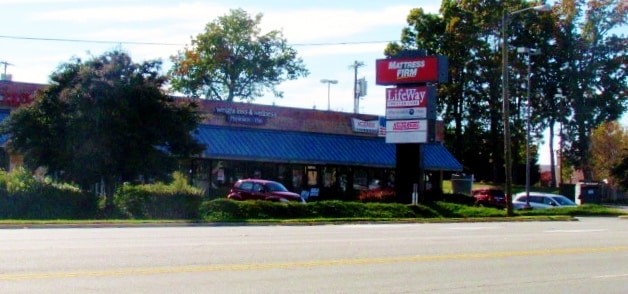
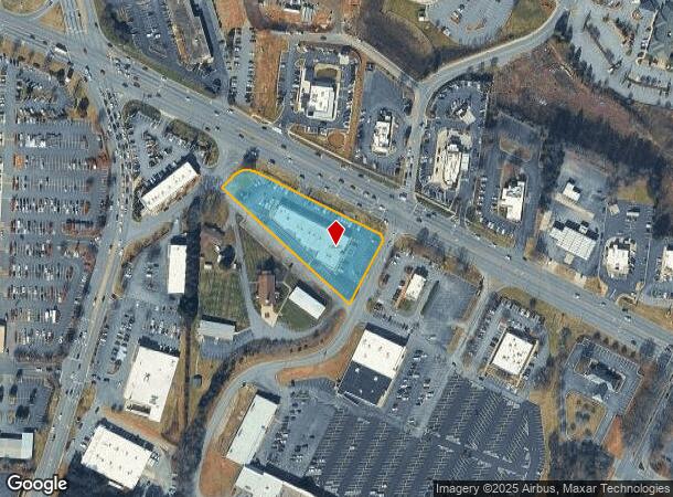
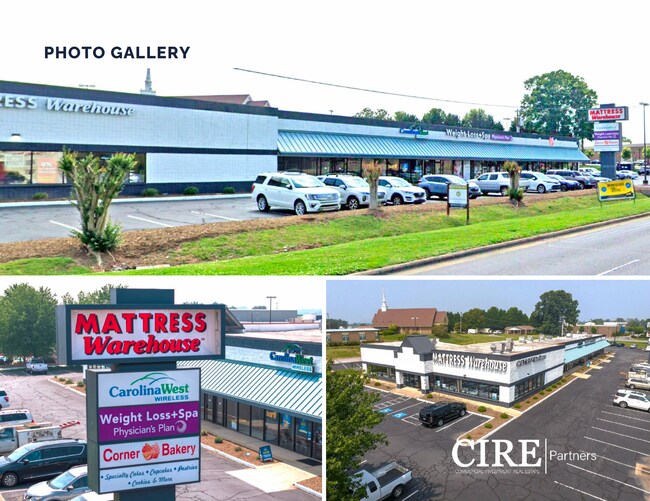
Property Record
1716 Us Highway 70 Se, Hickory, NC 28602
NEARBY LISTINGS FOR SALE OR LEASE
Property Detail
1716 Us Highway 70 Se
Hickory-Lenoir-Morganton, NC
Hickory Corners #6-8 Ph Ii
3712184045710000
LOTS 6-8 PLAT 21-151
Stripcommercialcenter
Catawba
X
North Carolina
3710371200J
6-8
2024
1.64 AC
2025
Catawba County
011102
Charlotte
15,565 SF
DEMOGRAPHICS near 1716 Us Highway 70 Se
1 Mile
3 Mile
5 Mile
2024 Total Population
1,681
23,281
70,344
2029 Population
1,758
24,426
73,509
Pop Growth 2024-2029
+ 4.58%
+ 4.92%
+ 4.50%
Average Age
40
39
41
2024 Total Households
731
9,294
28,920
HH Growth 2024-2029
+ 4.38%
+ 4.93%
+ 4.48%
Median Household Inc
$66,115
$46,029
$54,097
Avg Household Size
2.20
2.30
2.30
2024 Avg HH Vehicles
2.00
2.00
2.00
Median Home Value
$136,633
$147,755
$178,817
Median Year Built
1993
1976
1979
Nearby Places
Map Layers
Map Styles
 Street
 Aerial
- Restaurants
- Banks
- Shops
- Fitness
- Groceries
SALE & LEASE HISTORY
LISTING DATE
SALE/LEASE

Sep 27, 2024
For Lease
Sep 24, 2016
For Sale
Oct 28, 2019
For Sale
Feb 26, 2020
For Lease
Aug 03, 2023
For Sale
Aug 01, 2023
For Sale
Aug 01, 2023
For Sale
Apr 19, 2022
For Lease
Apr 03, 2018
For Sale
Nearby Properties
Address
Land Use
TOTAL SIZE
Lot Size
Zoning
Address
Land Use
TOTAL SIZE
Lot Size
Zoning
83,982 SF
96.78 AC
OI
Address
Land Use
TOTAL SIZE
Lot Size
Zoning
10,422 SF
4.23 AC
OI
Address
Land Use
TOTAL SIZE
Lot Size
Zoning
30,725 SF
17.17 AC
PD
Address
Land Use
TOTAL SIZE
Lot Size
Zoning
57.59 AC
OI
Address
Land Use
TOTAL SIZE
Lot Size
Zoning
29,600 SF
19.05 AC
PD
Address
Land Use
TOTAL SIZE
Lot Size
Zoning
219,033 SF
32.95 AC
IND-CZ
Address
Land Use
TOTAL SIZE
Lot Size
Zoning
31,111 SF
8.79 AC
PD
Address
Land Use
TOTAL SIZE
Lot Size
Zoning
14,125 SF
16.76 AC
PD
Address
Land Use
TOTAL SIZE
Lot Size
Zoning
14,140 SF
15.26 AC
PD
Address
Land Use
TOTAL SIZE
Lot Size
Zoning
7,164 SF
45.82 AC
OI
Address
Land Use
TOTAL SIZE
Lot Size
Zoning
19.87 AC
OI
Address
Land Use
TOTAL SIZE
Lot Size
Zoning
27,008 SF
12.02 AC
R-3
Address
Land Use
TOTAL SIZE
Lot Size
Zoning
94,152 SF
14.46 AC
IND
Address
Land Use
TOTAL SIZE
Lot Size
Zoning
19,444 SF
8.84 AC
PD
Address
Land Use
TOTAL SIZE
Lot Size
Zoning
57,658 SF
10.64 AC
OI
Address
Land Use
TOTAL SIZE
Lot Size
Zoning
326,813 SF
37.87 AC
IND
Address
Land Use
TOTAL SIZE
Lot Size
Zoning
31,854 SF
24.55 AC
PD
Address
Land Use
TOTAL SIZE
Lot Size
Zoning
353,092 SF
35.72 AC
IND
Address
Land Use
TOTAL SIZE
Lot Size
Zoning
9,376 SF
0.75 AC
C-1
Address
Land Use
TOTAL SIZE
Lot Size
Zoning
300,990 SF
30.42 AC
IND-CZ
Address
Land Use
TOTAL SIZE
Lot Size
Zoning
125,920 SF
19.53 AC
C-3
Address
Land Use
TOTAL SIZE
Lot Size
Zoning
191,040 SF
25.30 AC
IND-CZ
Address
Land Use
TOTAL SIZE
Lot Size
Zoning
30,415 SF
1.59 AC
C-1
Address
Land Use
TOTAL SIZE
Lot Size
Zoning
234,541 SF
9.07 AC
C-3
Address
Land Use
TOTAL SIZE
Lot Size
Zoning
146,932 SF
27.08 AC
C-3
Address
Land Use
TOTAL SIZE
Lot Size
Zoning
123,778 SF
19.99 AC
C-3
Address
Land Use
TOTAL SIZE
Lot Size
Zoning
8,960 SF
14.07 AC
R-4
Address
Land Use
TOTAL SIZE
Lot Size
Zoning
201,590 SF
20.31 AC
C-3
Address
Land Use
TOTAL SIZE
Lot Size
Zoning
31,778 SF
2.53 AC
OI
Address
Land Use
TOTAL SIZE
Lot Size
Zoning
385,204 SF
14.33 AC
C-3
The World's #1 Commercial Real Estate Marketplace
Connect with us
© 2025 CoStar Group
The information above has been obtained from sources believed reliable. While we do not doubt its accuracy we have not verified it and make no guarantee, warranty or representation about it. It is your responsibility to independently confirm its accuracy and completeness. Any projections, opinions, assumptions, or estimates used are for example only and do not represent the current or future performance of the property. The value of this transaction to you depends on tax and other factors which should be evaluated by your tax, financial, and legal advisors. You and your advisors should conduct a careful, independent investigation of the property to determine to your satisfaction the suitability of the property for your needs.