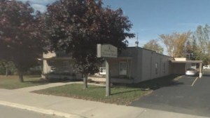
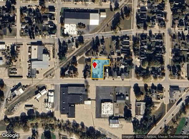
Property Record
1638 10Th Ave, Menominee, MI 49858
NEARBY LISTINGS FOR SALE OR LEASE
Property Detail
1638 10Th Ave
Marinette, WI-MI
W G Boswells 2Nd Add
051-013-090-00
Menominee
Sfr
Michigan
X
0.51 AC
26109C0801E
Upper Peninsula
1,929 SF
Other Market Areas
DEMOGRAPHICS near 1638 10Th Ave
1 Mile
3 Mile
5 Mile
2024 Total Population
8,144
23,756
24,890
2029 Population
8,291
24,112
25,243
Pop Growth 2024-2029
+ 1.81%
+ 1.50%
+ 1.42%
Average Age
43
43
43
2024 Total Households
3,872
10,961
11,449
HH Growth 2024-2029
+ 1.86%
+ 1.52%
+ 1.45%
Median Household Inc
$49,898
$52,384
$53,247
Avg Household Size
2.00
2.10
2.10
2024 Avg HH Vehicles
1.00
2.00
2.00
Median Home Value
$82,173
$96,494
$100,773
Median Year Built
1958
1969
1970
Nearby Places
- Restaurants
- Banks
- Shops
- Fitness
- Groceries
Nearby Properties
Address
Land Use
TOTAL SIZE
Lot Size
Zoning
Address
Land Use
TOTAL SIZE
Lot Size
Zoning
90.49 AC
Address
Land Use
TOTAL SIZE
Lot Size
Zoning
19.68 AC
Address
Land Use
TOTAL SIZE
Lot Size
Zoning
8.50 AC
Address
Land Use
TOTAL SIZE
Lot Size
Zoning
28.13 AC
Address
Land Use
TOTAL SIZE
Lot Size
Zoning
27.53 AC
Address
Land Use
TOTAL SIZE
Lot Size
Zoning
14.64 AC
Address
Land Use
TOTAL SIZE
Lot Size
Zoning
26.56 AC
Address
Land Use
TOTAL SIZE
Lot Size
Zoning
13.41 AC
Address
Land Use
TOTAL SIZE
Lot Size
Zoning
88.80 AC
Address
Land Use
TOTAL SIZE
Lot Size
Zoning
2.32 AC
Address
Land Use
TOTAL SIZE
Lot Size
Zoning
44.93 AC
Address
Land Use
TOTAL SIZE
Lot Size
Zoning
38.43 AC
Address
Land Use
TOTAL SIZE
Lot Size
Zoning
5.44 AC
Address
Land Use
TOTAL SIZE
Lot Size
Zoning
37.80 AC
Address
Land Use
TOTAL SIZE
Lot Size
Zoning
6.55 AC
Address
Land Use
TOTAL SIZE
Lot Size
Zoning
1.91 AC
Address
Land Use
TOTAL SIZE
Lot Size
Zoning
Address
Land Use
TOTAL SIZE
Lot Size
Zoning
Address
Land Use
TOTAL SIZE
Lot Size
Zoning
1.77 AC
Address
Land Use
TOTAL SIZE
Lot Size
Zoning
15.41 AC
Address
Land Use
TOTAL SIZE
Lot Size
Zoning
9.65 AC
Address
Land Use
TOTAL SIZE
Lot Size
Zoning
106,262 SF
18.66 AC
R1
Address
Land Use
TOTAL SIZE
Lot Size
Zoning
Address
Land Use
TOTAL SIZE
Lot Size
Zoning
265,051 SF
13.99 AC
R1
Address
Land Use
TOTAL SIZE
Lot Size
Zoning
6.55 AC
Address
Land Use
TOTAL SIZE
Lot Size
Zoning
2.36 AC
Address
Land Use
TOTAL SIZE
Lot Size
Zoning
Address
Land Use
TOTAL SIZE
Lot Size
Zoning
Address
Land Use
TOTAL SIZE
Lot Size
Zoning
447,920 SF
48.04 AC
M1
Address
Land Use
TOTAL SIZE
Lot Size
Zoning
307,172 SF
29.15 AC
R1
The World's #1 Commercial Real Estate Marketplace
Connect with us
© 2025 CoStar Group
The information above has been obtained from sources believed reliable. While we do not doubt its accuracy we have not verified it and make no guarantee, warranty or representation about it. It is your responsibility to independently confirm its accuracy and completeness. Any projections, opinions, assumptions, or estimates used are for example only and do not represent the current or future performance of the property. The value of this transaction to you depends on tax and other factors which should be evaluated by your tax, financial, and legal advisors. You and your advisors should conduct a careful, independent investigation of the property to determine to your satisfaction the suitability of the property for your needs.