Property Record
1717 Baker St E, Saint Joseph, MN 56374
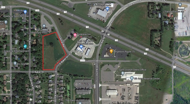
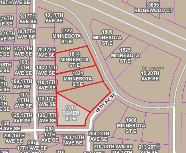
This Property Is For Sale
Property Detail
1717 Baker St E
St. Cloud, MN
LOT 003 BLK 003 K & L PROPERTIES SECTION 11 TOWNSHIP 124 RANGE 029 SECTION 11 TOWNSHIP 124 RANGE 029
84.53547.0010
STEARNS
Agriculturalland
Minnesota
B and X Area of moderate flood hazard, usually the area between the limits of the 100-year and 500-year floods.
3
2025
1 AC
2025
Stearns County
011308
Minneapolis/St Paul
NEARBY LISTINGS FOR SALE OR LEASE
DEMOGRAPHICS near 1717 Baker St E
1 mile
3 mile
5 mile
2025 Total Population
4,181
15,478
48,684
2030 Population
4,369
16,026
50,782
Pop Growth 2025-2030
+ 4.50%
+ 3.54%
+ 4.31%
Average Age
33
37
38
2025 Total Households
1,326
5,914
19,340
HH Growth 2025-2030
+ 5.35%
+ 3.80%
+ 4.42%
Median Household Inc
$73,695
$72,383
$69,699
Avg Household Size
2.30
2.30
2.40
2025 Avg HH Vehicles
2.00
2.00
2.00
Median Home Value
$247,588
$274,086
$269,153
Median Year Built
1994
1995
1995
Nearby Places
Map Layers
Map Styles
 Street
 Aerial
Transit
 Traffic
 Biking
Places
Listings with unknown addresses are not visible on the map
- Restaurants
- Banks
- Shops
- Fitness
- Groceries
PUBLIC TRANSPORTATION
COMMUTER RAIL
St. Cloud Amtrak Station (Empire Builder - Amtrak)
Drive
Walk
Distance
St. Cloud Amtrak Station (Empire Builder - Amtrak)
15 min
8.0 mi
Freight Ports
Port Milwaukee
Drive
Walk
Distance
Port Milwaukee
455 min
411.3 mi
Nearby Properties
Address
Land Use
TOTAL SIZE
Lot Size
Zoning
Address
Land Use
TOTAL SIZE
Lot Size
Zoning
52,983 SF
22 AC
Address
Land Use
TOTAL SIZE
Lot Size
Zoning
148,150 SF
71.46 AC
Address
Land Use
TOTAL SIZE
Lot Size
Zoning
19.06 AC
Address
Land Use
TOTAL SIZE
Lot Size
Zoning
628,000 SF
40.51 AC
PUD16
Address
Land Use
TOTAL SIZE
Lot Size
Zoning
5.34 AC
Address
Land Use
TOTAL SIZE
Lot Size
Zoning
113,268 SF
12 AC
PUD32
Address
Land Use
TOTAL SIZE
Lot Size
Zoning
269,390 SF
15.77 AC
Address
Land Use
TOTAL SIZE
Lot Size
Zoning
146,285 SF
19.10 AC
Address
Land Use
TOTAL SIZE
Lot Size
Zoning
51.70 AC
PL20B2
Address
Land Use
TOTAL SIZE
Lot Size
Zoning
555,652 SF
26.04 AC
PUD16
Address
Land Use
TOTAL SIZE
Lot Size
Zoning
289,470 SF
23 AC
I3
Address
Land Use
TOTAL SIZE
Lot Size
Zoning
288,861 SF
30.27 AC
I3
Address
Land Use
TOTAL SIZE
Lot Size
Zoning
9,448 SF
5.10 AC
Address
Land Use
TOTAL SIZE
Lot Size
Zoning
Address
Land Use
TOTAL SIZE
Lot Size
Zoning
320,450 SF
26.20 AC
I3
Address
Land Use
TOTAL SIZE
Lot Size
Zoning
3,088 SF
67.89 AC
PL20B1
Address
Land Use
TOTAL SIZE
Lot Size
Zoning
28,858 SF
1.89 AC
Address
Land Use
TOTAL SIZE
Lot Size
Zoning
33,796 SF
4.83 AC
Address
Land Use
TOTAL SIZE
Lot Size
Zoning
13,219 SF
2.19 AC
Address
Land Use
TOTAL SIZE
Lot Size
Zoning
44,631 SF
15.01 AC
Address
Land Use
TOTAL SIZE
Lot Size
Zoning
21,528 SF
4.31 AC
R5
Address
Land Use
TOTAL SIZE
Lot Size
Zoning
139,430 SF
17.05 AC
I3
Address
Land Use
TOTAL SIZE
Lot Size
Zoning
27,694 SF
7.17 AC
Address
Land Use
TOTAL SIZE
Lot Size
Zoning
84,646 SF
4.83 AC
PUD32
Address
Land Use
TOTAL SIZE
Lot Size
Zoning
84,646 SF
4.68 AC
PUD32
Address
Land Use
TOTAL SIZE
Lot Size
Zoning
4.15 AC
Address
Land Use
TOTAL SIZE
Lot Size
Zoning
Address
Land Use
TOTAL SIZE
Lot Size
Zoning
The World's #1 Commercial Real Estate Marketplace
Connect with us
© 2026 CoStar Group
The information above has been obtained from sources believed reliable. While we do not doubt its accuracy we have not verified it and make no guarantee, warranty or representation about it. It is your responsibility to independently confirm its accuracy and completeness. Any projections, opinions, assumptions, or estimates used are for example only and do not represent the current or future performance of the property. The value of this transaction to you depends on tax and other factors which should be evaluated by your tax, financial, and legal advisors. You and your advisors should conduct a careful, independent investigation of the property to determine to your satisfaction the suitability of the property for your needs.