Property Record
1717 Cornhusker Hwy, Lincoln, NE 68521
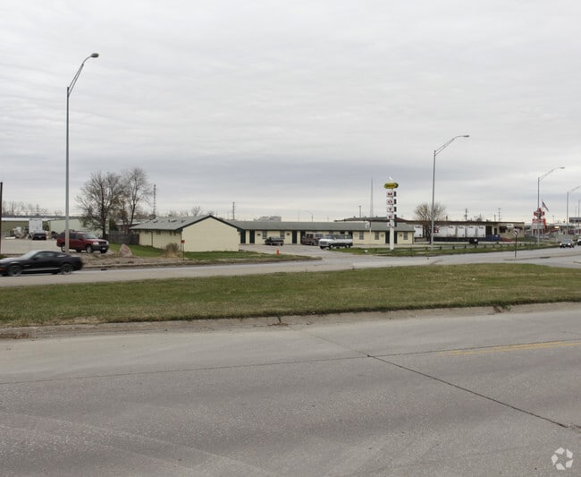
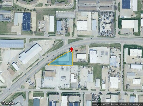
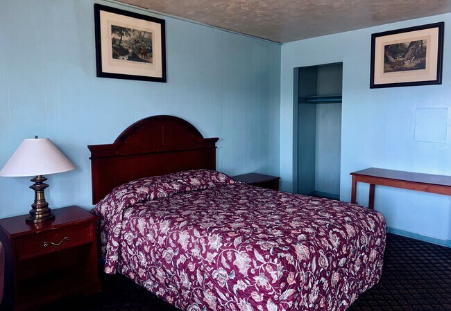
This Property Is For Sale
NEARBY LISTINGS FOR SALE OR LEASE
Property Detail
1717 Cornhusker Hwy
Lincoln, NE
6Th Principal Meridian
11-13-100-016-000
S13, T10, R6, 6TH PRINCIPAL MERIDIAN, IRREGULAR TRACT LOT 134 NW
Hotel
Lancaster
AE
Nebraska
31109C0305F
134
2024
0.71 AC
2025
Lincoln
003003
Lincoln
5,388 SF
DEMOGRAPHICS near 1717 Cornhusker Hwy
1 Mile
3 Mile
5 Mile
2024 Total Population
8,257
101,649
199,684
2029 Population
8,587
105,647
207,016
Pop Growth 2024-2029
+ 4.00%
+ 3.93%
+ 3.67%
Average Age
36
34
36
2024 Total Households
3,254
42,499
81,545
HH Growth 2024-2029
+ 4.06%
+ 4.20%
+ 3.90%
Median Household Inc
$45,728
$44,875
$55,293
Avg Household Size
2.50
2.20
2.30
2024 Avg HH Vehicles
2.00
2.00
2.00
Median Home Value
$149,561
$175,262
$188,762
Median Year Built
1981
1977
1973
Nearby Places
- Restaurants
- Banks
- Shops
- Fitness
- Groceries
PUBLIC TRANSPORTATION
COMMUTER RAIL
Lincoln Amtrak Station (California Zephyr - Amtrak)
DRIVE
WALK
Distance
Lincoln Amtrak Station (California Zephyr - Amtrak)
6 min
3.2 mi
AIRPORT
Lincoln
DRIVE
WALK
Distance
Lincoln
8 min
4.3 mi
Freight Ports
Tulsa Port Of Catoosa
DRIVE
WALK
Distance
Tulsa Port Of Catoosa
475 min
394.5 mi
Nearby Properties
Address
Land Use
TOTAL SIZE
Lot Size
Zoning
Address
Land Use
TOTAL SIZE
Lot Size
Zoning
382,244 SF
44.25 AC
R6
Address
Land Use
TOTAL SIZE
Lot Size
Zoning
30,018 SF
100.37 AC
R3
Address
Land Use
TOTAL SIZE
Lot Size
Zoning
134,835 SF
1.22 AC
B4
Address
Land Use
TOTAL SIZE
Lot Size
Zoning
131,328 SF
2.07 AC
P
Address
Land Use
TOTAL SIZE
Lot Size
Zoning
65,430 SF
1.12 AC
B4
Address
Land Use
TOTAL SIZE
Lot Size
Zoning
182,668 SF
2.07 AC
B4
Address
Land Use
TOTAL SIZE
Lot Size
Zoning
35,233 SF
28.52 AC
NULL
Address
Land Use
TOTAL SIZE
Lot Size
Zoning
72,047 SF
1.03 AC
B4
Address
Land Use
TOTAL SIZE
Lot Size
Zoning
216,894 SF
1.47 AC
B4
Address
Land Use
TOTAL SIZE
Lot Size
Zoning
708,074 SF
66.04 AC
I1
Address
Land Use
TOTAL SIZE
Lot Size
Zoning
48,088 SF
28.06 AC
R5
Address
Land Use
TOTAL SIZE
Lot Size
Zoning
71,046 SF
23.72 AC
R5
Address
Land Use
TOTAL SIZE
Lot Size
Zoning
217,115 SF
2.03 AC
B4
Address
Land Use
TOTAL SIZE
Lot Size
Zoning
37,240 SF
17.06 AC
NULL
Address
Land Use
TOTAL SIZE
Lot Size
Zoning
189,854 SF
2.07 AC
P
Address
Land Use
TOTAL SIZE
Lot Size
Zoning
287,193 SF
6.62 AC
B4
Address
Land Use
TOTAL SIZE
Lot Size
Zoning
27,171 SF
14.68 AC
NULL
Address
Land Use
TOTAL SIZE
Lot Size
Zoning
174,576 SF
2.07 AC
R6
Address
Land Use
TOTAL SIZE
Lot Size
Zoning
65,064 SF
1.39 AC
R6
Address
Land Use
TOTAL SIZE
Lot Size
Zoning
92,418 SF
0.79 AC
B4
Address
Land Use
TOTAL SIZE
Lot Size
Zoning
119,257 SF
1.68 AC
B4
Address
Land Use
TOTAL SIZE
Lot Size
Zoning
180,578 SF
1.32 AC
P
Address
Land Use
TOTAL SIZE
Lot Size
Zoning
56,867 SF
22.10 AC
NULL
Address
Land Use
TOTAL SIZE
Lot Size
Zoning
32,110 SF
9.64 AC
B2
Address
Land Use
TOTAL SIZE
Lot Size
Zoning
22,552 SF
16.68 AC
NULL
Address
Land Use
TOTAL SIZE
Lot Size
Zoning
8,824 SF
12.33 AC
R5
Address
Land Use
TOTAL SIZE
Lot Size
Zoning
11.90 AC
P
Address
Land Use
TOTAL SIZE
Lot Size
Zoning
65,967 SF
11.65 AC
NULL
Address
Land Use
TOTAL SIZE
Lot Size
Zoning
63,914 SF
12.22 AC
R5
The World's #1 Commercial Real Estate Marketplace
Connect with us
© 2025 CoStar Group
The information above has been obtained from sources believed reliable. While we do not doubt its accuracy we have not verified it and make no guarantee, warranty or representation about it. It is your responsibility to independently confirm its accuracy and completeness. Any projections, opinions, assumptions, or estimates used are for example only and do not represent the current or future performance of the property. The value of this transaction to you depends on tax and other factors which should be evaluated by your tax, financial, and legal advisors. You and your advisors should conduct a careful, independent investigation of the property to determine to your satisfaction the suitability of the property for your needs.