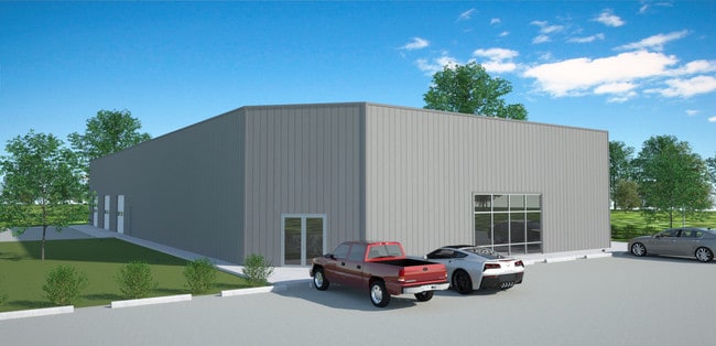
Property Record
1717 Highway 351 Rd, Jonesboro, AR 72405
NEARBY LISTINGS FOR SALE OR LEASE
Property Detail
1717 Highway 351 Rd
12-154334-00906
Cdc Partition Plat
Storebuilding
PT NE
A
Craighead
05031C0100D
Arkansas
2025
0.86 AC
2025
Arkansas North Area
000501
Other Market Areas
12,016 SF
Jonesboro, AR
DEMOGRAPHICS near 1717 Highway 351 Rd
1 Mile
3 Mile
5 Mile
2024 Total Population
2,744
33,537
66,001
2029 Population
2,974
35,922
70,564
Pop Growth 2024-2029
+ 8.38%
+ 7.11%
+ 6.91%
Average Age
36
35
36
2024 Total Households
1,109
12,798
26,314
HH Growth 2024-2029
+ 8.30%
+ 7.40%
+ 7.00%
Median Household Inc
$57,499
$38,360
$41,457
Avg Household Size
2.40
2.40
2.30
2024 Avg HH Vehicles
2.00
2.00
2.00
Median Home Value
$190,722
$179,019
$174,783
Median Year Built
2007
1995
1991
Nearby Places
Map Layers
Map Styles
 Street
 Aerial
- Restaurants
- Banks
- Shops
- Fitness
- Groceries
Nearby Properties
Address
Land Use
TOTAL SIZE
Lot Size
Zoning
Address
Land Use
TOTAL SIZE
Lot Size
Zoning
217,426 SF
48.05 AC
Address
Land Use
TOTAL SIZE
Lot Size
Zoning
353,512 SF
15.01 AC
Address
Land Use
TOTAL SIZE
Lot Size
Zoning
45,783 SF
346.92 AC
Address
Land Use
TOTAL SIZE
Lot Size
Zoning
94,649 SF
18.69 AC
Address
Land Use
TOTAL SIZE
Lot Size
Zoning
61,868 SF
15.69 AC
Address
Land Use
TOTAL SIZE
Lot Size
Zoning
219,080 SF
10.93 AC
Address
Land Use
TOTAL SIZE
Lot Size
Zoning
99,212 SF
7.49 AC
Address
Land Use
TOTAL SIZE
Lot Size
Zoning
Address
Land Use
TOTAL SIZE
Lot Size
Zoning
74,067 SF
8.71 AC
Address
Land Use
TOTAL SIZE
Lot Size
Zoning
62,340 SF
6.78 AC
Address
Land Use
TOTAL SIZE
Lot Size
Zoning
49,568 SF
14 AC
Address
Land Use
TOTAL SIZE
Lot Size
Zoning
57,576 SF
2.06 AC
Address
Land Use
TOTAL SIZE
Lot Size
Zoning
2,685 SF
3.05 AC
Address
Land Use
TOTAL SIZE
Lot Size
Zoning
55,727 SF
2.29 AC
Address
Land Use
TOTAL SIZE
Lot Size
Zoning
13,132 SF
3.69 AC
Address
Land Use
TOTAL SIZE
Lot Size
Zoning
51,360 SF
3.83 AC
Address
Land Use
TOTAL SIZE
Lot Size
Zoning
29,614 SF
1.83 AC
Address
Land Use
TOTAL SIZE
Lot Size
Zoning
25,080 SF
1.47 AC
Address
Land Use
TOTAL SIZE
Lot Size
Zoning
7,830 SF
1.22 AC
Address
Land Use
TOTAL SIZE
Lot Size
Zoning
34,514 SF
3.85 AC
Address
Land Use
TOTAL SIZE
Lot Size
Zoning
21,918 SF
2.77 AC
Address
Land Use
TOTAL SIZE
Lot Size
Zoning
12,024 SF
1.02 AC
Address
Land Use
TOTAL SIZE
Lot Size
Zoning
42,840 SF
4.24 AC
Address
Land Use
TOTAL SIZE
Lot Size
Zoning
18,244 SF
3.20 AC
Address
Land Use
TOTAL SIZE
Lot Size
Zoning
2,540 SF
4.10 AC
Address
Land Use
TOTAL SIZE
Lot Size
Zoning
5,354 SF
2 AC
Address
Land Use
TOTAL SIZE
Lot Size
Zoning
6,868 SF
7.16 AC
Address
Land Use
TOTAL SIZE
Lot Size
Zoning
61,614 SF
4.16 AC
Address
Land Use
TOTAL SIZE
Lot Size
Zoning
20,397 SF
1.80 AC
Address
Land Use
TOTAL SIZE
Lot Size
Zoning
52,300 SF
8.85 AC
The World's #1 Commercial Real Estate Marketplace
Connect with us
© 2026 CoStar Group
The information above has been obtained from sources believed reliable. While we do not doubt its accuracy we have not verified it and make no guarantee, warranty or representation about it. It is your responsibility to independently confirm its accuracy and completeness. Any projections, opinions, assumptions, or estimates used are for example only and do not represent the current or future performance of the property. The value of this transaction to you depends on tax and other factors which should be evaluated by your tax, financial, and legal advisors. You and your advisors should conduct a careful, independent investigation of the property to determine to your satisfaction the suitability of the property for your needs.