Property Record
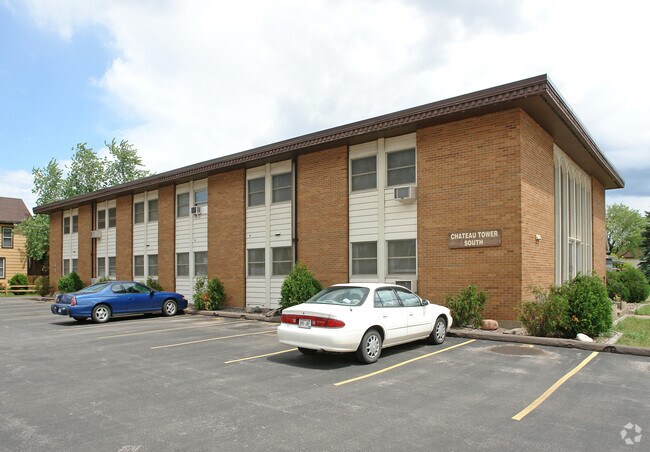
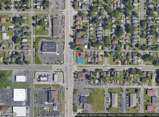
1717 N 28Th St, Superior, WI 54880

NEARBY LISTINGS FOR SALE OR LEASE
-
-
View all Superior listings for sale on LoopNet.com
Property Detail
1717 N 28Th St
Duluth, MN-WI
WEMYSS ADD TO WEST SUPERIOR LOTS 23 THRU 26, BL 20 #925589
07-807-02896-00
Douglas
Commercialnec
Wisconsin
X
23-26
27137C3880E
0.30 AC
2024
Douglas County
2024
Duluth
020600
DEMOGRAPHICS near 1717 N 28Th St
1 Mile
3 Mile
5 Mile
2024 Total Population
8,249
22,868
42,289
2029 Population
8,153
22,593
41,673
Pop Growth 2024-2029
(1.16%)
(1.20%)
(1.46%)
Average Age
38
40
40
2024 Total Households
3,430
10,064
18,850
HH Growth 2024-2029
(1.31%)
(1.26%)
(1.53%)
Median Household Inc
$52,274
$51,503
$50,416
Avg Household Size
2.10
2.10
2.10
2024 Avg HH Vehicles
2.00
2.00
2.00
Median Home Value
$151,587
$150,370
$151,665
Median Year Built
1949
1956
1948
Nearby Places
Map Layers
Map Styles
 Street
 Aerial
- Restaurants
- Banks
- Shops
- Fitness
- Groceries
PUBLIC TRANSPORTATION
AIRPORT
Duluth International
DRIVE
WALK
Distance
Duluth International
28 min
14.1 mi
Nearby Properties
Address
Land Use
TOTAL SIZE
Lot Size
Zoning
Address
Land Use
TOTAL SIZE
Lot Size
Zoning
175 AC
W1
Address
Land Use
TOTAL SIZE
Lot Size
Zoning
50.82 AC
M2
Address
Land Use
TOTAL SIZE
Lot Size
Zoning
2.81 AC
PDD
Address
Land Use
TOTAL SIZE
Lot Size
Zoning
1.45 AC
C3
Address
Land Use
TOTAL SIZE
Lot Size
Zoning
135.91 AC
M2
Address
Land Use
TOTAL SIZE
Lot Size
Zoning
1.36 AC
C2
Address
Land Use
TOTAL SIZE
Lot Size
Zoning
21.96 AC
Address
Land Use
TOTAL SIZE
Lot Size
Zoning
4.17 AC
C2
Address
Land Use
TOTAL SIZE
Lot Size
Zoning
8.50 AC
W1
Address
Land Use
TOTAL SIZE
Lot Size
Zoning
28.37 AC
W1
Address
Land Use
TOTAL SIZE
Lot Size
Zoning
2.47 AC
C2
Address
Land Use
TOTAL SIZE
Lot Size
Zoning
6.94 AC
Address
Land Use
TOTAL SIZE
Lot Size
Zoning
27.99 AC
C2
Address
Land Use
TOTAL SIZE
Lot Size
Zoning
52.06 AC
M2
Address
Land Use
TOTAL SIZE
Lot Size
Zoning
2 AC
R3
Address
Land Use
TOTAL SIZE
Lot Size
Zoning
6.01 AC
M2
Address
Land Use
TOTAL SIZE
Lot Size
Zoning
0.68 AC
R3
Address
Land Use
TOTAL SIZE
Lot Size
Zoning
2.44 AC
C2
Address
Land Use
TOTAL SIZE
Lot Size
Zoning
20.01 AC
Address
Land Use
TOTAL SIZE
Lot Size
Zoning
1.34 AC
Address
Land Use
TOTAL SIZE
Lot Size
Zoning
3.42 AC
R3
Address
Land Use
TOTAL SIZE
Lot Size
Zoning
7.05 AC
M2
Address
Land Use
TOTAL SIZE
Lot Size
Zoning
4.47 AC
Address
Land Use
TOTAL SIZE
Lot Size
Zoning
9.84 AC
C2
Address
Land Use
TOTAL SIZE
Lot Size
Zoning
24.54 AC
W1
Address
Land Use
TOTAL SIZE
Lot Size
Zoning
11.43 AC
R3
Address
Land Use
TOTAL SIZE
Lot Size
Zoning
1.97 AC
PDD
Address
Land Use
TOTAL SIZE
Lot Size
Zoning
Address
Land Use
TOTAL SIZE
Lot Size
Zoning
1.41 AC
C4
Address
Land Use
TOTAL SIZE
Lot Size
Zoning
3.54 AC
W1
The World's #1 Commercial Real Estate Marketplace
Connect with us
© 2025 CoStar Group
The information above has been obtained from sources believed reliable. While we do not doubt its accuracy we have not verified it and make no guarantee, warranty or representation about it. It is your responsibility to independently confirm its accuracy and completeness. Any projections, opinions, assumptions, or estimates used are for example only and do not represent the current or future performance of the property. The value of this transaction to you depends on tax and other factors which should be evaluated by your tax, financial, and legal advisors. You and your advisors should conduct a careful, independent investigation of the property to determine to your satisfaction the suitability of the property for your needs.