Property Record
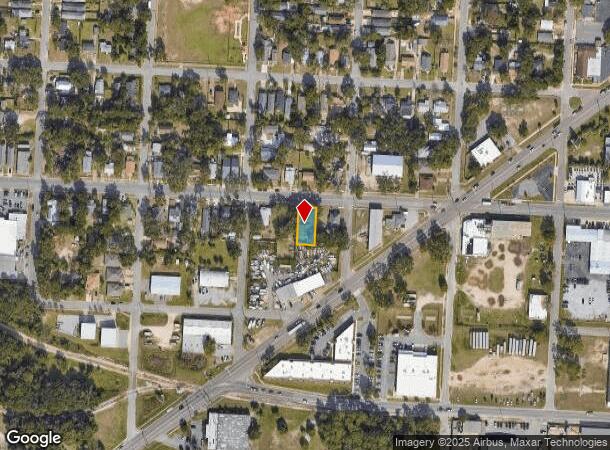
1717 W Government St, Pensacola, FL 32502
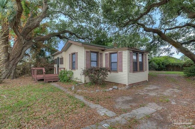
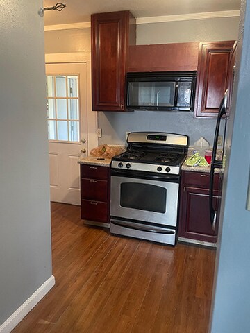
This Property Is For Sale
NEARBY LISTINGS FOR SALE OR LEASE
Property Detail
1717 W Government St
Pensacola-Ferry Pass-Brent, FL
Maxent Tract Pdb 14
00-0S-00-9080-004-127
Escambia
Sfr
Florida
X
0.17 AC
12033C0390G
Central Pensacola/S Brent
848 SF
Pensacola
DEMOGRAPHICS near 1717 W Government St
1 Mile
3 Mile
5 Mile
2024 Total Population
5,734
48,387
126,512
2029 Population
6,237
51,621
133,494
Pop Growth 2024-2029
+ 8.77%
+ 6.68%
+ 5.52%
Average Age
42
40
38
2024 Total Households
2,744
20,221
48,843
HH Growth 2024-2029
+ 9.15%
+ 6.89%
+ 5.76%
Median Household Inc
$33,814
$35,748
$45,058
Avg Household Size
2.00
2.20
2.30
2024 Avg HH Vehicles
1.00
1.00
2.00
Median Home Value
$172,982
$162,744
$179,149
Median Year Built
1958
1962
1970
Nearby Places
- Restaurants
- Banks
- Shops
- Fitness
- Groceries
PUBLIC TRANSPORTATION
AIRPORT
Pensacola International
DRIVE
WALK
Distance
Pensacola International
15 min
7.2 mi
Freight Ports
Port of Mobile
DRIVE
WALK
Distance
Port of Mobile
71 min
58.3 mi
Nearby Properties
Address
Land Use
TOTAL SIZE
Lot Size
Zoning
Address
Land Use
TOTAL SIZE
Lot Size
Zoning
544,835 SF
3.29 AC
C-2,C-2A
Address
Land Use
TOTAL SIZE
Lot Size
Zoning
365,037 SF
5.79 AC
C-3
Address
Land Use
TOTAL SIZE
Lot Size
Zoning
296,361 SF
13.03 AC
GRD
Address
Land Use
TOTAL SIZE
Lot Size
Zoning
368,724 SF
3.17 AC
C-2A
Address
Land Use
TOTAL SIZE
Lot Size
Zoning
56,970 SF
5.94 AC
WRD
Address
Land Use
TOTAL SIZE
Lot Size
Zoning
289,397 SF
12.38 AC
PUB
Address
Land Use
TOTAL SIZE
Lot Size
Zoning
334,324 SF
55.06 AC
PUB
Address
Land Use
TOTAL SIZE
Lot Size
Zoning
353,428 SF
30.10 AC
M-1
Address
Land Use
TOTAL SIZE
Lot Size
Zoning
327,045 SF
7.47 AC
C-2A
Address
Land Use
TOTAL SIZE
Lot Size
Zoning
178,451 SF
3.88 AC
GRD
Address
Land Use
TOTAL SIZE
Lot Size
Zoning
188,512 SF
11.44 AC
COM
Address
Land Use
TOTAL SIZE
Lot Size
Zoning
114,000 SF
3.23 AC
C-2,C-2A
Address
Land Use
TOTAL SIZE
Lot Size
Zoning
96,686 SF
1.06 AC
C-2A
Address
Land Use
TOTAL SIZE
Lot Size
Zoning
282,738 SF
14.64 AC
PUB
Address
Land Use
TOTAL SIZE
Lot Size
Zoning
258,438 SF
48.49 AC
PUB
Address
Land Use
TOTAL SIZE
Lot Size
Zoning
99,623 SF
1.87 AC
C-2A
Address
Land Use
TOTAL SIZE
Lot Size
Zoning
145,264 SF
9.84 AC
SSD
Address
Land Use
TOTAL SIZE
Lot Size
Zoning
169,346 SF
15.21 AC
HDR
Address
Land Use
TOTAL SIZE
Lot Size
Zoning
115,500 SF
3.48 AC
C-2
Address
Land Use
TOTAL SIZE
Lot Size
Zoning
151,996 SF
30.44 AC
HDR
Address
Land Use
TOTAL SIZE
Lot Size
Zoning
166,204 SF
0.97 AC
C-2A
Address
Land Use
TOTAL SIZE
Lot Size
Zoning
75,877 SF
1.55 AC
WRD
Address
Land Use
TOTAL SIZE
Lot Size
Zoning
130,516 SF
4.55 AC
R-2
Address
Land Use
TOTAL SIZE
Lot Size
Zoning
55,337 SF
0.95 AC
C-2A,HC-2
Address
Land Use
TOTAL SIZE
Lot Size
Zoning
99,147 SF
5.89 AC
HDMU
Address
Land Use
TOTAL SIZE
Lot Size
Zoning
116,020 SF
4.71 AC
MDR
Address
Land Use
TOTAL SIZE
Lot Size
Zoning
81,549 SF
0.46 AC
WRD
Address
Land Use
TOTAL SIZE
Lot Size
Zoning
184,232 SF
11.32 AC
HC/LI
Address
Land Use
TOTAL SIZE
Lot Size
Zoning
129,532 SF
10.84 AC
COM
Address
Land Use
TOTAL SIZE
Lot Size
Zoning
73,923 SF
2.87 AC
GRD
The World's #1 Commercial Real Estate Marketplace
Connect with us
© 2025 CoStar Group
The information above has been obtained from sources believed reliable. While we do not doubt its accuracy we have not verified it and make no guarantee, warranty or representation about it. It is your responsibility to independently confirm its accuracy and completeness. Any projections, opinions, assumptions, or estimates used are for example only and do not represent the current or future performance of the property. The value of this transaction to you depends on tax and other factors which should be evaluated by your tax, financial, and legal advisors. You and your advisors should conduct a careful, independent investigation of the property to determine to your satisfaction the suitability of the property for your needs.