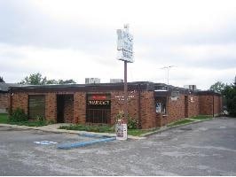
Property Record
1718 S Ingram Ave, Sedalia, MO 65301


NEARBY LISTINGS FOR SALE OR LEASE
Property Detail
1718 S Ingram Ave
Sedalia, MO
BEGIN PT W LI INGRAM 142.13' S S LI 17TH ST SW 167.52' NW 277.67' NE 189.90' SE 138.68' SW 29.16' SE 139.23' TO POB 10 45 21
152010210001000
Pettis
Medicalbuilding
Missouri
2025
1.10 AC
2024
Missouri North Area
481000
Other Market Areas
13,517 SF
DEMOGRAPHICS near 1718 S Ingram Ave
1 Mile
3 Mile
5 Mile
2024 Total Population
9,839
26,555
32,053
2029 Population
10,130
27,252
32,802
Pop Growth 2024-2029
+ 2.96%
+ 2.62%
+ 2.34%
Average Age
37
39
39
2024 Total Households
3,866
10,723
12,694
HH Growth 2024-2029
+ 2.95%
+ 2.65%
+ 2.39%
Median Household Inc
$45,634
$48,930
$51,977
Avg Household Size
2.40
2.40
2.40
2024 Avg HH Vehicles
2.00
2.00
2.00
Median Home Value
$89,747
$128,215
$143,137
Median Year Built
1958
1966
1970
Nearby Places
Map Layers
Map Styles
 Street
 Aerial
- Restaurants
- Banks
- Shops
- Fitness
- Groceries
PUBLIC TRANSPORTATION
COMMUTER RAIL
Sedalia Amtrak Station (Lincoln Service Missouri River Runner - Amtrak, Missouri River Runner - Amtrak)
DRIVE
WALK
Distance
Sedalia Amtrak Station (Lincoln Service Missouri River Runner - Amtrak, Missouri River Runner - Amtrak)
4 min
1.5 mi
Freight Ports
Tulsa Port Of Catoosa
DRIVE
WALK
Distance
Tulsa Port Of Catoosa
314 min
272.4 mi
Nearby Properties
Address
Land Use
TOTAL SIZE
Lot Size
Zoning
Address
Land Use
TOTAL SIZE
Lot Size
Zoning
Address
Land Use
TOTAL SIZE
Lot Size
Zoning
52,605 SF
26.56 AC
Address
Land Use
TOTAL SIZE
Lot Size
Zoning
201,452 SF
15 AC
Address
Land Use
TOTAL SIZE
Lot Size
Zoning
494,190 SF
45.23 AC
Address
Land Use
TOTAL SIZE
Lot Size
Zoning
69,763 SF
9.96 AC
Address
Land Use
TOTAL SIZE
Lot Size
Zoning
440,184 SF
26 AC
Address
Land Use
TOTAL SIZE
Lot Size
Zoning
303,444 SF
40.75 AC
Address
Land Use
TOTAL SIZE
Lot Size
Zoning
223,284 SF
38.25 AC
Address
Land Use
TOTAL SIZE
Lot Size
Zoning
13,158 SF
9.20 AC
Address
Land Use
TOTAL SIZE
Lot Size
Zoning
66,910 SF
44.75 AC
Address
Land Use
TOTAL SIZE
Lot Size
Zoning
11,149 SF
3.81 AC
Address
Land Use
TOTAL SIZE
Lot Size
Zoning
8,699 SF
0.70 AC
Address
Land Use
TOTAL SIZE
Lot Size
Zoning
18,000 SF
342.42 AC
Address
Land Use
TOTAL SIZE
Lot Size
Zoning
108,294 SF
12.31 AC
Address
Land Use
TOTAL SIZE
Lot Size
Zoning
8,700 SF
6.62 AC
Address
Land Use
TOTAL SIZE
Lot Size
Zoning
91,564 SF
4.58 AC
Address
Land Use
TOTAL SIZE
Lot Size
Zoning
22,950 SF
3.34 AC
Address
Land Use
TOTAL SIZE
Lot Size
Zoning
52,400 SF
4.74 AC
Address
Land Use
TOTAL SIZE
Lot Size
Zoning
14,190 SF
1.58 AC
Address
Land Use
TOTAL SIZE
Lot Size
Zoning
32,640 SF
2.17 AC
Address
Land Use
TOTAL SIZE
Lot Size
Zoning
63,240 SF
6.12 AC
Address
Land Use
TOTAL SIZE
Lot Size
Zoning
24,905 SF
4.13 AC
Address
Land Use
TOTAL SIZE
Lot Size
Zoning
30,000 SF
5.54 AC
Address
Land Use
TOTAL SIZE
Lot Size
Zoning
66,046 SF
2.25 AC
Address
Land Use
TOTAL SIZE
Lot Size
Zoning
8,786 SF
2.26 AC
Address
Land Use
TOTAL SIZE
Lot Size
Zoning
47,268 SF
7.50 AC
Address
Land Use
TOTAL SIZE
Lot Size
Zoning
31,026 SF
1.87 AC
Address
Land Use
TOTAL SIZE
Lot Size
Zoning
6,088 SF
7.02 AC
Address
Land Use
TOTAL SIZE
Lot Size
Zoning
75,245 SF
1.04 AC
Address
Land Use
TOTAL SIZE
Lot Size
Zoning
70,075 SF
7.90 AC
The World's #1 Commercial Real Estate Marketplace
Connect with us
© 2025 CoStar Group
The information above has been obtained from sources believed reliable. While we do not doubt its accuracy we have not verified it and make no guarantee, warranty or representation about it. It is your responsibility to independently confirm its accuracy and completeness. Any projections, opinions, assumptions, or estimates used are for example only and do not represent the current or future performance of the property. The value of this transaction to you depends on tax and other factors which should be evaluated by your tax, financial, and legal advisors. You and your advisors should conduct a careful, independent investigation of the property to determine to your satisfaction the suitability of the property for your needs.