Property Record
17180 Wood Rd, Riverside, CA 92508
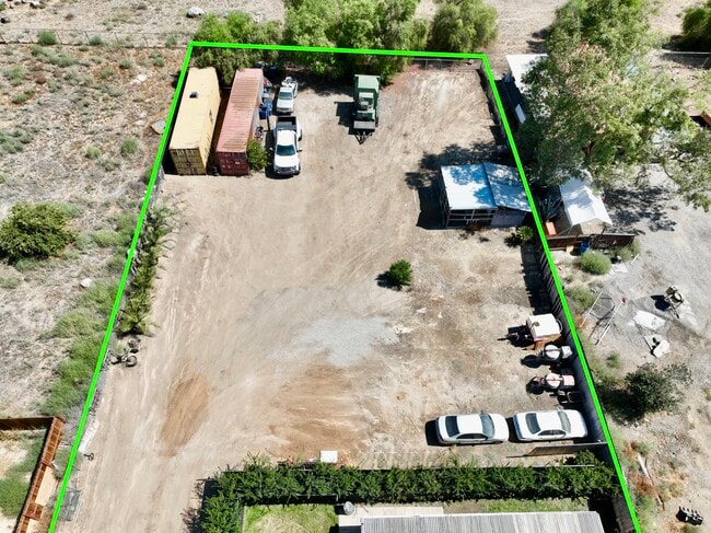
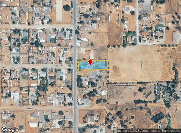
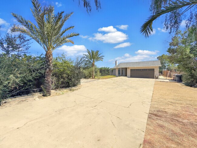
This Property Is For Sale
NEARBY LISTINGS FOR SALE OR LEASE
-
-
-
-
-
-
-
No Photo
-
View all Riverside listings for sale on LoopNet.com
Property Detail
17180 Wood Rd
Riverside-San Bernardino-Ontario, CA
Woodcrest Ac
266-180-004
Riverside
Sfr
California
X
0.69 AC
06065C1405G
Moreno Valley/Perris
1,561 SF
Inland Empire (California)
DEMOGRAPHICS near 17180 Wood Rd
1 Mile
3 Mile
5 Mile
2024 Total Population
7,485
49,176
87,243
2029 Population
7,740
50,248
89,124
Pop Growth 2024-2029
+ 3.41%
+ 2.18%
+ 2.16%
Average Age
38
38
38
2024 Total Households
1,981
13,481
24,783
HH Growth 2024-2029
+ 3.13%
+ 1.87%
+ 1.79%
Median Household Inc
$126,056
$130,974
$123,582
Avg Household Size
3.60
3.50
3.30
2024 Avg HH Vehicles
3.00
3.00
3.00
Median Home Value
$744,518
$743,723
$735,093
Median Year Built
1996
1994
1989
Nearby Places
- Restaurants
- Banks
- Shops
- Fitness
- Groceries
PUBLIC TRANSPORTATION
COMMUTER RAIL
Moreno Valley/March Field (Metrolink 91-Perris Valley Line - Metrolink Trains)
DRIVE
WALK
Distance
Moreno Valley/March Field (Metrolink 91-Perris Valley Line - Metrolink Trains)
10 min
6.0 mi
Riverside-Downtown (91 Line - Southern California Regional Rail Authority (Metrolink), Inland Empire-Orange County Line - Southern California Regional Rail Authority (Metrolink), Riverside Line - Southern California Regional Rail Authority (Metrolink))
DRIVE
WALK
Distance
Riverside-Downtown (91 Line - Southern California Regional Rail Authority (Metrolink), Inland Empire-Orange County Line - Southern California Regional Rail Authority (Metrolink), Riverside Line - Southern California Regional Rail Authority (Metrolink))
17 min
9.3 mi
AIRPORT
Ontario International
DRIVE
WALK
Distance
Ontario International
39 min
24.6 mi
Freight Ports
Port of Long Beach
DRIVE
WALK
Distance
Port of Long Beach
78 min
58.6 mi
Nearby Properties
Address
Land Use
TOTAL SIZE
Lot Size
Zoning
Address
Land Use
TOTAL SIZE
Lot Size
Zoning
782,209 SF
35.98 AC
Address
Land Use
TOTAL SIZE
Lot Size
Zoning
1,007,387 SF
48.02 AC
RR
Address
Land Use
TOTAL SIZE
Lot Size
Zoning
1,001,789 SF
44.53 AC
RR
Address
Land Use
TOTAL SIZE
Lot Size
Zoning
38,560 SF
12.04 AC
R3
Address
Land Use
TOTAL SIZE
Lot Size
Zoning
500,174 SF
22.96 AC
Address
Land Use
TOTAL SIZE
Lot Size
Zoning
4,439 SF
78.46 AC
Address
Land Use
TOTAL SIZE
Lot Size
Zoning
140,030 SF
9.45 AC
Address
Land Use
TOTAL SIZE
Lot Size
Zoning
136,738 SF
25.18 AC
Address
Land Use
TOTAL SIZE
Lot Size
Zoning
219,928 SF
10.74 AC
Address
Land Use
TOTAL SIZE
Lot Size
Zoning
123,500 SF
5.98 AC
Address
Land Use
TOTAL SIZE
Lot Size
Zoning
127,134 SF
7.31 AC
Address
Land Use
TOTAL SIZE
Lot Size
Zoning
97,060 SF
5.07 AC
Address
Land Use
TOTAL SIZE
Lot Size
Zoning
90,960 SF
4.83 AC
Address
Land Use
TOTAL SIZE
Lot Size
Zoning
78,960 SF
3.97 AC
Address
Land Use
TOTAL SIZE
Lot Size
Zoning
51,665 SF
10.32 AC
Address
Land Use
TOTAL SIZE
Lot Size
Zoning
53,085 SF
3.03 AC
Address
Land Use
TOTAL SIZE
Lot Size
Zoning
219,928 SF
4.72 AC
Address
Land Use
TOTAL SIZE
Lot Size
Zoning
47,426 SF
4.32 AC
Address
Land Use
TOTAL SIZE
Lot Size
Zoning
86,938 SF
6.94 AC
Address
Land Use
TOTAL SIZE
Lot Size
Zoning
21.60 AC
CPS
Address
Land Use
TOTAL SIZE
Lot Size
Zoning
45,503 SF
3.56 AC
Address
Land Use
TOTAL SIZE
Lot Size
Zoning
40,925 SF
2.94 AC
Address
Land Use
TOTAL SIZE
Lot Size
Zoning
18,800 SF
3.50 AC
Address
Land Use
TOTAL SIZE
Lot Size
Zoning
15,513 SF
4.86 AC
CPS
Address
Land Use
TOTAL SIZE
Lot Size
Zoning
3.91 AC
Address
Land Use
TOTAL SIZE
Lot Size
Zoning
14,479 SF
1.43 AC
Address
Land Use
TOTAL SIZE
Lot Size
Zoning
40,925 SF
2.91 AC
The World's #1 Commercial Real Estate Marketplace
Connect with us
© 2025 CoStar Group
The information above has been obtained from sources believed reliable. While we do not doubt its accuracy we have not verified it and make no guarantee, warranty or representation about it. It is your responsibility to independently confirm its accuracy and completeness. Any projections, opinions, assumptions, or estimates used are for example only and do not represent the current or future performance of the property. The value of this transaction to you depends on tax and other factors which should be evaluated by your tax, financial, and legal advisors. You and your advisors should conduct a careful, independent investigation of the property to determine to your satisfaction the suitability of the property for your needs.