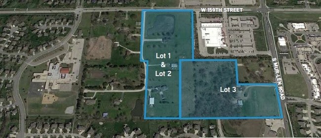
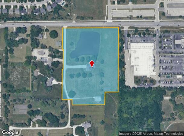
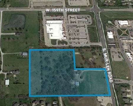
Property Record
17181 W 159Th St, Olathe, KS 66062
This Property Is For Sale
NEARBY LISTINGS FOR SALE OR LEASE
Property Detail
17181 W 159Th St
Kansas City, MO-KS
Johnson
6F241418-3001
Kansas
Sfr
9.56 AC
X
South Johnson County
20091C0109G
Kansas City
3,733 SF
DEMOGRAPHICS near 17181 W 159Th St
1 Mile
3 Mile
5 Mile
2024 Total Population
14,551
58,885
143,247
2029 Population
15,182
61,295
149,485
Pop Growth 2024-2029
+ 4.34%
+ 4.09%
+ 4.35%
Average Age
36
37
37
2024 Total Households
4,587
19,723
49,592
HH Growth 2024-2029
+ 4.45%
+ 4.21%
+ 4.45%
Median Household Inc
$123,687
$111,247
$103,676
Avg Household Size
3.10
2.90
2.80
2024 Avg HH Vehicles
2.00
2.00
2.00
Median Home Value
$303,662
$295,246
$323,088
Median Year Built
2000
1992
1993
Nearby Places
Map Layers
Map Styles
 Street
 Aerial
- Restaurants
- Banks
- Shops
- Fitness
- Groceries
PUBLIC TRANSPORTATION
AIRPORT
Kansas City International
DRIVE
WALK
Distance
Kansas City International
54 min
41.0 mi
Nearby Properties
Address
Land Use
TOTAL SIZE
Lot Size
Zoning
Address
Land Use
TOTAL SIZE
Lot Size
Zoning
401,604 SF
28.35 AC
CP-O
Address
Land Use
TOTAL SIZE
Lot Size
Zoning
512,643 SF
75.55 AC
AG
Address
Land Use
TOTAL SIZE
Lot Size
Zoning
211,054 SF
77.48 AC
R-1
Address
Land Use
TOTAL SIZE
Lot Size
Zoning
130,576 SF
15.20 AC
RP-4
Address
Land Use
TOTAL SIZE
Lot Size
Zoning
720,320 SF
39.19 AC
MP-2
Address
Land Use
TOTAL SIZE
Lot Size
Zoning
508,664 SF
29.46 AC
MP-2
Address
Land Use
TOTAL SIZE
Lot Size
Zoning
103,102 SF
31.90 AC
R-1
Address
Land Use
TOTAL SIZE
Lot Size
Zoning
499,084 SF
28.99 AC
RUR
Address
Land Use
TOTAL SIZE
Lot Size
Zoning
129,325 SF
4.50 AC
R-1
Address
Land Use
TOTAL SIZE
Lot Size
Zoning
137,955 SF
23.80 AC
R-1
Address
Land Use
TOTAL SIZE
Lot Size
Zoning
137,122 SF
7.68 AC
C-1
Address
Land Use
TOTAL SIZE
Lot Size
Zoning
150,122 SF
17.48 AC
R-1
Address
Land Use
TOTAL SIZE
Lot Size
Zoning
934,106 SF
34.09 AC
BP
Address
Land Use
TOTAL SIZE
Lot Size
Zoning
157,344 SF
12.69 AC
R-1
Address
Land Use
TOTAL SIZE
Lot Size
Zoning
236,108 SF
12.38 AC
R-1
Address
Land Use
TOTAL SIZE
Lot Size
Zoning
130,605 SF
18.01 AC
R-1
Address
Land Use
TOTAL SIZE
Lot Size
Zoning
64,953 SF
32.62 AC
CTY RUR
Address
Land Use
TOTAL SIZE
Lot Size
Zoning
71,221 SF
17.13 AC
R-1
Address
Land Use
TOTAL SIZE
Lot Size
Zoning
117,084 SF
10.69 AC
R-1
Address
Land Use
TOTAL SIZE
Lot Size
Zoning
71,221 SF
13.84 AC
R-1
Address
Land Use
TOTAL SIZE
Lot Size
Zoning
81,753 SF
20.88 AC
R-1
Address
Land Use
TOTAL SIZE
Lot Size
Zoning
244,992 SF
15.75 AC
MP-2
Address
Land Use
TOTAL SIZE
Lot Size
Zoning
73,159 SF
12.54 AC
R-1
Address
Land Use
TOTAL SIZE
Lot Size
Zoning
81,096 SF
121.93 AC
AG
Address
Land Use
TOTAL SIZE
Lot Size
Zoning
72,091 SF
11.33 AC
R-1
Address
Land Use
TOTAL SIZE
Lot Size
Zoning
92,328 SF
9.49 AC
M-1
Address
Land Use
TOTAL SIZE
Lot Size
Zoning
69,723 SF
11.29 AC
R-1
Address
Land Use
TOTAL SIZE
Lot Size
Zoning
62,832 SF
15.43 AC
CTY RUR
Address
Land Use
TOTAL SIZE
Lot Size
Zoning
65,691 SF
11.51 AC
RP-1
Address
Land Use
TOTAL SIZE
Lot Size
Zoning
54,005 SF
10.49 AC
R-1/PUD
The World's #1 Commercial Real Estate Marketplace
Connect with us
© 2025 CoStar Group
The information above has been obtained from sources believed reliable. While we do not doubt its accuracy we have not verified it and make no guarantee, warranty or representation about it. It is your responsibility to independently confirm its accuracy and completeness. Any projections, opinions, assumptions, or estimates used are for example only and do not represent the current or future performance of the property. The value of this transaction to you depends on tax and other factors which should be evaluated by your tax, financial, and legal advisors. You and your advisors should conduct a careful, independent investigation of the property to determine to your satisfaction the suitability of the property for your needs.