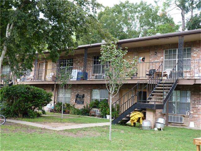
Property Record
1719 6Th St, Rosenberg, TX 77471


NEARBY LISTINGS FOR SALE OR LEASE
-
-
View all Rosenberg listings for sale on LoopNet.com
Property Detail
1719 6Th St
Houston-The Woodlands-Sugar Land, TX
First Hillyer Addn
3035-00-003-0090-901
FIRST HILLYER ADDN, BLOCK C, LOT 9 & 11
Multifamilydwelling
Fort Bend
X
Texas
48157C0245L
9,11
2024
0.29 AC
2025
Richmond/Rosenberg
675200
Houston
6,120 SF
DEMOGRAPHICS near 1719 6Th St
1 Mile
3 Mile
5 Mile
2024 Total Population
12,091
48,909
98,800
2029 Population
14,459
58,940
120,229
Pop Growth 2024-2029
+ 19.58%
+ 20.51%
+ 21.69%
Average Age
38
36
37
2024 Total Households
4,241
16,628
33,215
HH Growth 2024-2029
+ 20.18%
+ 21.13%
+ 22.35%
Median Household Inc
$44,057
$56,545
$69,763
Avg Household Size
2.80
2.90
2.90
2024 Avg HH Vehicles
2.00
2.00
2.00
Median Home Value
$155,962
$199,560
$251,318
Median Year Built
1976
1991
2008
Nearby Places
Map Layers
Map Styles
 Street
 Aerial
- Restaurants
- Banks
- Shops
- Fitness
- Groceries
PUBLIC TRANSPORTATION
AIRPORT
William P Hobby
DRIVE
WALK
Distance
William P Hobby
57 min
41.1 mi
Freight Ports
Port of Houston
DRIVE
WALK
Distance
Port of Houston
59 min
41.8 mi
SALE & LEASE HISTORY
LISTING DATE
SALE/LEASE

Jun 21, 2021
For Sale
Nearby Properties
Address
Land Use
TOTAL SIZE
Lot Size
Zoning
Address
Land Use
TOTAL SIZE
Lot Size
Zoning
44.35 AC
YOSN
Address
Land Use
TOTAL SIZE
Lot Size
Zoning
449,167 SF
73.44 AC
IY
Address
Land Use
TOTAL SIZE
Lot Size
Zoning
672,112 SF
81.77 AC
YHN
Address
Land Use
TOTAL SIZE
Lot Size
Zoning
283,393 SF
93.42 AC
Address
Land Use
TOTAL SIZE
Lot Size
Zoning
10.84 AC
Address
Land Use
TOTAL SIZE
Lot Size
Zoning
Address
Land Use
TOTAL SIZE
Lot Size
Zoning
78,077 SF
16.29 AC
Address
Land Use
TOTAL SIZE
Lot Size
Zoning
169,798 SF
16.29 AC
Address
Land Use
TOTAL SIZE
Lot Size
Zoning
224,099 SF
11.85 AC
Address
Land Use
TOTAL SIZE
Lot Size
Zoning
11.40 AC
Address
Land Use
TOTAL SIZE
Lot Size
Zoning
Address
Land Use
TOTAL SIZE
Lot Size
Zoning
98,691 SF
29.37 AC
Address
Land Use
TOTAL SIZE
Lot Size
Zoning
16.23 AC
Address
Land Use
TOTAL SIZE
Lot Size
Zoning
54,406 SF
13.13 AC
Address
Land Use
TOTAL SIZE
Lot Size
Zoning
3,680 SF
38.68 AC
SMH
Address
Land Use
TOTAL SIZE
Lot Size
Zoning
18.86 AC
Address
Land Use
TOTAL SIZE
Lot Size
Zoning
12.21 AC
Address
Land Use
TOTAL SIZE
Lot Size
Zoning
96,992 SF
14.76 AC
SM
Address
Land Use
TOTAL SIZE
Lot Size
Zoning
28.37 AC
Z
Address
Land Use
TOTAL SIZE
Lot Size
Zoning
64.02 AC
YQ
Address
Land Use
TOTAL SIZE
Lot Size
Zoning
54.25 AC
L
Address
Land Use
TOTAL SIZE
Lot Size
Zoning
94,080 SF
6.23 AC
H
Address
Land Use
TOTAL SIZE
Lot Size
Zoning
46,959 SF
8.36 AC
S
Address
Land Use
TOTAL SIZE
Lot Size
Zoning
1,216 SF
24.38 AC
YZS
Address
Land Use
TOTAL SIZE
Lot Size
Zoning
Address
Land Use
TOTAL SIZE
Lot Size
Zoning
66,896 SF
18.60 AC
ZNY
Address
Land Use
TOTAL SIZE
Lot Size
Zoning
103,380 SF
5.44 AC
NYX
Address
Land Use
TOTAL SIZE
Lot Size
Zoning
103,204 SF
5.50 AC
YX
Address
Land Use
TOTAL SIZE
Lot Size
Zoning
25.69 AC
Address
Land Use
TOTAL SIZE
Lot Size
Zoning
202,234 SF
30.07 AC
S
The World's #1 Commercial Real Estate Marketplace
Connect with us
© 2025 CoStar Group
The information above has been obtained from sources believed reliable. While we do not doubt its accuracy we have not verified it and make no guarantee, warranty or representation about it. It is your responsibility to independently confirm its accuracy and completeness. Any projections, opinions, assumptions, or estimates used are for example only and do not represent the current or future performance of the property. The value of this transaction to you depends on tax and other factors which should be evaluated by your tax, financial, and legal advisors. You and your advisors should conduct a careful, independent investigation of the property to determine to your satisfaction the suitability of the property for your needs.