Property Record
1719 New Hope Rd, Lawrenceville, GA 30045
Property Detail
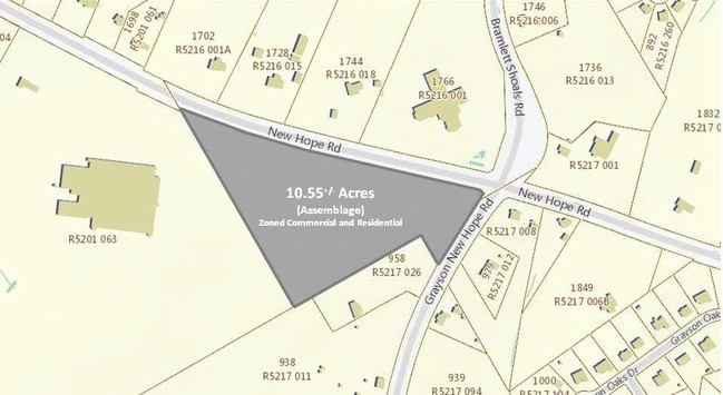
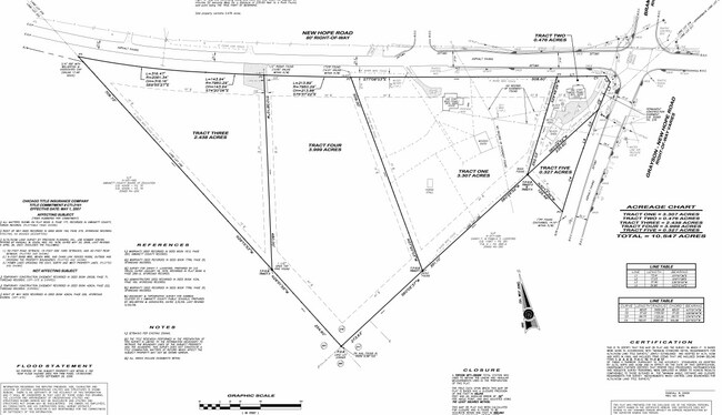
1719 New Hope Rd
5-216-010
NEW HOPE RD
Medicalbuilding
Gwinnett
OI
Georgia
B and X Area of moderate flood hazard, usually the area between the limits of the 100-year and 500-year floods.
217
2025
2.40 AC
2025
Lawrenceville/Lilburn
050588
Atlanta
7,104 SF
Atlanta-Sandy Springs-Roswell, GA
NEARBY LISTINGS FOR SALE OR LEASE
DEMOGRAPHICS near 1719 New Hope Rd
1 mile
3 mile
5 mile
2025 Total Population
7,310
49,039
140,215
2030 Population
7,604
51,728
148,479
Pop Growth 2025-2030
+ 4.02%
+ 5.48%
+ 5.89%
Average Age
36
38
37
2025 Total Households
2,064
14,465
42,891
HH Growth 2025-2030
+ 4.07%
+ 5.59%
+ 6.04%
Median Household Inc
$101,293
$99,819
$90,816
Avg Household Size
3.50
3.30
3.20
2025 Avg HH Vehicles
2.00
2.00
2.00
Median Home Value
$423,852
$424,833
$408,185
Median Year Built
2004
2003
2003
Nearby Places
Map Layers
Map Styles
 Street
 Aerial
Layers
 Traffic
 Biking
Places
Listings with unknown addresses are not visible on the map
- Restaurants
- Banks
- Shops
- Fitness
- Groceries
PUBLIC TRANSPORTATION
AIRPORT
Hartsfield - Jackson Atlanta International
Drive
Walk
Distance
Hartsfield - Jackson Atlanta International
66 min
46.5 mi
SALE & LEASE HISTORY
LISTING DATE
SALE/LEASE

Sep 24, 2016
For Sale
Mar 23, 2017
For Sale
Jun 27, 2017
For Sale
Aug 01, 2017
For Sale
Nearby Properties
Address
Land Use
TOTAL SIZE
Lot Size
Zoning
Address
Land Use
TOTAL SIZE
Lot Size
Zoning
386,454 SF
150 AC
C1
Address
Land Use
TOTAL SIZE
Lot Size
Zoning
702.83 AC
R100
Address
Land Use
TOTAL SIZE
Lot Size
Zoning
194,295 SF
36.59 AC
R100
Address
Land Use
TOTAL SIZE
Lot Size
Zoning
222,622 SF
49.17 AC
R100
Address
Land Use
TOTAL SIZE
Lot Size
Zoning
145,681 SF
49.84 AC
RA200
Address
Land Use
TOTAL SIZE
Lot Size
Zoning
309,156 SF
17.39 AC
OI
Address
Land Use
TOTAL SIZE
Lot Size
Zoning
4,408 SF
148.92 AC
R100
Address
Land Use
TOTAL SIZE
Lot Size
Zoning
125,700 SF
33.85 AC
C2
Address
Land Use
TOTAL SIZE
Lot Size
Zoning
101,193 SF
5.34 AC
C2
Address
Land Use
TOTAL SIZE
Lot Size
Zoning
87,365 SF
11.32 AC
BG
Address
Land Use
TOTAL SIZE
Lot Size
Zoning
112,640 SF
5.17 AC
C2
Address
Land Use
TOTAL SIZE
Lot Size
Zoning
105,453 SF
14.57 AC
OI
Address
Land Use
TOTAL SIZE
Lot Size
Zoning
135,192 SF
16.88 AC
R75
Address
Land Use
TOTAL SIZE
Lot Size
Zoning
68,134 SF
9.48 AC
BG
Address
Land Use
TOTAL SIZE
Lot Size
Zoning
37,246 SF
13.64 AC
RA200
Address
Land Use
TOTAL SIZE
Lot Size
Zoning
327.79 AC
R100
Address
Land Use
TOTAL SIZE
Lot Size
Zoning
69,088 SF
4.19 AC
C2
Address
Land Use
TOTAL SIZE
Lot Size
Zoning
50,972 SF
0.90 AC
C2
Address
Land Use
TOTAL SIZE
Lot Size
Zoning
49,016 SF
4.24 AC
C2
Address
Land Use
TOTAL SIZE
Lot Size
Zoning
44,170 SF
8.51 AC
M1
Address
Land Use
TOTAL SIZE
Lot Size
Zoning
15,044 SF
10.66 AC
MU
Address
Land Use
TOTAL SIZE
Lot Size
Zoning
19,973 SF
4.91 AC
R100
Address
Land Use
TOTAL SIZE
Lot Size
Zoning
13,513 SF
15.23 AC
M2
Address
Land Use
TOTAL SIZE
Lot Size
Zoning
13,080 SF
17.53 AC
RA200
Address
Land Use
TOTAL SIZE
Lot Size
Zoning
17,882 SF
11.67 AC
R100
Address
Land Use
TOTAL SIZE
Lot Size
Zoning
31,710 SF
2.98 AC
C2
Address
Land Use
TOTAL SIZE
Lot Size
Zoning
6,644 SF
16.16 AC
R100
Address
Land Use
TOTAL SIZE
Lot Size
Zoning
22,796 SF
1.84 AC
C1
Address
Land Use
TOTAL SIZE
Lot Size
Zoning
22,282 SF
0.82 AC
PUD
Address
Land Use
TOTAL SIZE
Lot Size
Zoning
25,338 SF
6.43 AC
OI
The World's #1 Commercial Real Estate Marketplace
Connect with us
© 2026 CoStar Group
The information above has been obtained from sources believed reliable. While we do not doubt its accuracy we have not verified it and make no guarantee, warranty or representation about it. It is your responsibility to independently confirm its accuracy and completeness. Any projections, opinions, assumptions, or estimates used are for example only and do not represent the current or future performance of the property. The value of this transaction to you depends on tax and other factors which should be evaluated by your tax, financial, and legal advisors. You and your advisors should conduct a careful, independent investigation of the property to determine to your satisfaction the suitability of the property for your needs.