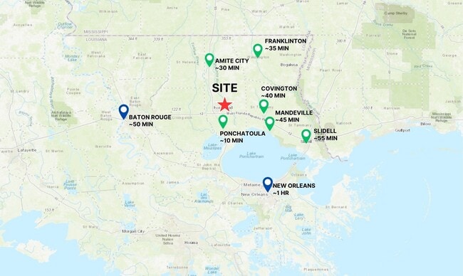
Property Record
I-12 N Service Rd, Ponchatoula, LA 70454

This Property Is For Sale
NEARBY LISTINGS FOR SALE OR LEASE
Property Detail
I-12 N Service Rd
Hammond, LA
Southwood Oaks
02151103
17.76A ML 13.60A IN NE14 OF SW14 OF SEC 31 T6SR8E B335 P464 B719 P879 B718 P767 B775 P854 B886 P468 SOUTHWOOD OAKS B895 P842-
Residentialacreage
Tangipahoa
AE
Louisiana
22105C0465F
17.76 AC
2024
Louisiana South Area
2024
Other Market Areas
954601
DEMOGRAPHICS near I-12 N Service Rd
1 Mile
3 Mile
5 Mile
2024 Total Population
2,674
33,476
64,912
2029 Population
2,906
36,443
70,497
Pop Growth 2024-2029
+ 8.68%
+ 8.86%
+ 8.60%
Average Age
39
37
37
2024 Total Households
1,023
12,918
25,166
HH Growth 2024-2029
+ 8.80%
+ 8.95%
+ 8.66%
Median Household Inc
$54,609
$48,776
$52,777
Avg Household Size
2.40
2.40
2.40
2024 Avg HH Vehicles
2.00
2.00
2.00
Median Home Value
$167,181
$189,844
$201,085
Median Year Built
1999
1995
1995
Nearby Places
Map Layers
Map Styles
 Street
 Aerial
- Restaurants
- Banks
- Shops
- Fitness
- Groceries
PUBLIC TRANSPORTATION
COMMUTER RAIL
Hammond Amtrak Station (City of New Orleans - Amtrak)
DRIVE
WALK
Distance
Hammond Amtrak Station (City of New Orleans - Amtrak)
6 min
2.8 mi
Freight Ports
Port of New Orleans
DRIVE
WALK
Distance
Port of New Orleans
77 min
56.7 mi
Nearby Properties
Address
Land Use
TOTAL SIZE
Lot Size
Zoning
Address
Land Use
TOTAL SIZE
Lot Size
Zoning
124,912 SF
12.50 AC
Address
Land Use
TOTAL SIZE
Lot Size
Zoning
666,424 SF
82.56 AC
Address
Land Use
TOTAL SIZE
Lot Size
Zoning
Address
Land Use
TOTAL SIZE
Lot Size
Zoning
1.74 AC
Address
Land Use
TOTAL SIZE
Lot Size
Zoning
126,240 SF
17.06 AC
Address
Land Use
TOTAL SIZE
Lot Size
Zoning
57,600 SF
2.07 AC
Address
Land Use
TOTAL SIZE
Lot Size
Zoning
152,841 SF
20.69 AC
Address
Land Use
TOTAL SIZE
Lot Size
Zoning
84,000 SF
8.32 AC
Address
Land Use
TOTAL SIZE
Lot Size
Zoning
82,860 SF
11.42 AC
Address
Land Use
TOTAL SIZE
Lot Size
Zoning
24,931 SF
2.67 AC
Address
Land Use
TOTAL SIZE
Lot Size
Zoning
24,823 SF
3 AC
Address
Land Use
TOTAL SIZE
Lot Size
Zoning
61,000 SF
11.91 AC
Address
Land Use
TOTAL SIZE
Lot Size
Zoning
1.56 AC
Address
Land Use
TOTAL SIZE
Lot Size
Zoning
432 SF
14.80 AC
Address
Land Use
TOTAL SIZE
Lot Size
Zoning
0.89 AC
Address
Land Use
TOTAL SIZE
Lot Size
Zoning
52,074 SF
7.40 AC
Address
Land Use
TOTAL SIZE
Lot Size
Zoning
127,380 SF
9.70 AC
Address
Land Use
TOTAL SIZE
Lot Size
Zoning
201,555 SF
11.17 AC
Address
Land Use
TOTAL SIZE
Lot Size
Zoning
236,540 SF
36.01 AC
Address
Land Use
TOTAL SIZE
Lot Size
Zoning
36,593 SF
1.54 AC
Address
Land Use
TOTAL SIZE
Lot Size
Zoning
73,922 SF
9.99 AC
Address
Land Use
TOTAL SIZE
Lot Size
Zoning
108,000 SF
9.78 AC
Address
Land Use
TOTAL SIZE
Lot Size
Zoning
22,000 SF
5.56 AC
Address
Land Use
TOTAL SIZE
Lot Size
Zoning
47,960 SF
9.16 AC
Address
Land Use
TOTAL SIZE
Lot Size
Zoning
96,064 SF
5.03 AC
Address
Land Use
TOTAL SIZE
Lot Size
Zoning
85,430 SF
6.44 AC
Address
Land Use
TOTAL SIZE
Lot Size
Zoning
60,480 SF
7.28 AC
Address
Land Use
TOTAL SIZE
Lot Size
Zoning
20,128 SF
20.77 AC
Address
Land Use
TOTAL SIZE
Lot Size
Zoning
22,507 SF
0.63 AC
Address
Land Use
TOTAL SIZE
Lot Size
Zoning
43,595 SF
10.17 AC
The World's #1 Commercial Real Estate Marketplace
Connect with us
© 2026 CoStar Group
The information above has been obtained from sources believed reliable. While we do not doubt its accuracy we have not verified it and make no guarantee, warranty or representation about it. It is your responsibility to independently confirm its accuracy and completeness. Any projections, opinions, assumptions, or estimates used are for example only and do not represent the current or future performance of the property. The value of this transaction to you depends on tax and other factors which should be evaluated by your tax, financial, and legal advisors. You and your advisors should conduct a careful, independent investigation of the property to determine to your satisfaction the suitability of the property for your needs.