Property Record
1720 Fall St, Cleveland, OH 44113
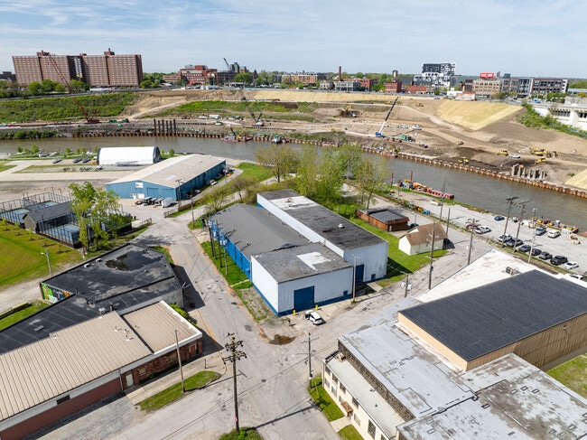

Property Detail
1720 Fall St
Cleveland-Elyria, OH
S/L 494-504 ALL 511 NEC 514-516 EP & PT VAC ALLEYS 0505 EP
101-16-035
Cuyahoga
Lightindustrial
Ohio
GI
505
2025
0.65 AC
2025
Downtown
107701
Cleveland
18,150 SF
NEARBY LISTINGS FOR SALE OR LEASE
DEMOGRAPHICS near 1720 Fall St
1 mile
3 mile
5 mile
2025 Total Population
16,224
97,097
243,710
2030 Population
16,446
96,731
241,471
Pop Growth 2025-2030
+ 1.37%
(0.38%)
(0.92%)
Average Age
36
36
38
2025 Total Households
9,120
45,150
113,010
HH Growth 2025-2030
+ 1.50%
+ 0.02%
(0.76%)
Median Household Inc
$70,906
$42,997
$44,332
Avg Household Size
1.60
2.00
2.00
2025 Avg HH Vehicles
1.00
1.00
1.00
Median Home Value
$341,604
$156,042
$138,902
Median Year Built
1953
1948
1947
Nearby Places
Map Layers
Map Styles
 Street
 Aerial
Layers
 Traffic
 Biking
Places
Listings with unknown addresses are not visible on the map
- Restaurants
- Banks
- Shops
- Fitness
- Groceries
PUBLIC TRANSPORTATION
COMMUTER RAIL
Cleveland Lakefront Station (Blue Line - Greater Cleveland Regional Transit Authority Rapid Transit (The Rapid), Green Line - Greater Cleveland Regional Transit Authority Rapid Transit (The Rapid))
Drive
Walk
Distance
Cleveland Lakefront Station (Blue Line - Greater Cleveland Regional Transit Authority Rapid Transit (The Rapid), Green Line - Greater Cleveland Regional Transit Authority Rapid Transit (The Rapid))
9 min
2.8 mi
AIRPORT
Cleveland-Hopkins International
Drive
Walk
Distance
Cleveland-Hopkins International
25 min
12.4 mi
SALE & LEASE HISTORY
LISTING DATE
SALE/LEASE

Aug 30, 2021
For Lease
Apr 20, 2022
For Lease
Nearby Properties
Address
Land Use
TOTAL SIZE
Lot Size
Zoning
Address
Land Use
TOTAL SIZE
Lot Size
Zoning
3,491,901 SF
34.32 AC
Address
Land Use
TOTAL SIZE
Lot Size
Zoning
753,970 SF
9.31 AC
GR
Address
Land Use
TOTAL SIZE
Lot Size
Zoning
1,570,958 SF
1.33 AC
GR
Address
Land Use
TOTAL SIZE
Lot Size
Zoning
17.45 AC
GI
Address
Land Use
TOTAL SIZE
Lot Size
Zoning
16.78 AC
SI
Address
Land Use
TOTAL SIZE
Lot Size
Zoning
710,780 SF
4.33 AC
GR
Address
Land Use
TOTAL SIZE
Lot Size
Zoning
136,701 SF
2.97 AC
GR
Address
Land Use
TOTAL SIZE
Lot Size
Zoning
765,607 SF
12.15 AC
GR
Address
Land Use
TOTAL SIZE
Lot Size
Zoning
788,580 SF
4.85 AC
GR
Address
Land Use
TOTAL SIZE
Lot Size
Zoning
434,475 SF
0.53 AC
Address
Land Use
TOTAL SIZE
Lot Size
Zoning
1,191,268 SF
3.94 AC
SI
Address
Land Use
TOTAL SIZE
Lot Size
Zoning
6.98 AC
SI
Address
Land Use
TOTAL SIZE
Lot Size
Zoning
148,486 SF
489.21 AC
GI
Address
Land Use
TOTAL SIZE
Lot Size
Zoning
5,100 SF
9.41 AC
GI
Address
Land Use
TOTAL SIZE
Lot Size
Zoning
263,723 SF
7.48 AC
GI
Address
Land Use
TOTAL SIZE
Lot Size
Zoning
1,130,924 SF
4.02 AC
SI
Address
Land Use
TOTAL SIZE
Lot Size
Zoning
1,181,536 SF
27.82 AC
RO
Address
Land Use
TOTAL SIZE
Lot Size
Zoning
228,154 SF
0.48 AC
GR
Address
Land Use
TOTAL SIZE
Lot Size
Zoning
3.23 AC
LLR
Address
Land Use
TOTAL SIZE
Lot Size
Zoning
1,003,787 SF
2.12 AC
GR
Address
Land Use
TOTAL SIZE
Lot Size
Zoning
1,467,599 SF
1.66 AC
GR
Address
Land Use
TOTAL SIZE
Lot Size
Zoning
493,911 SF
1.88 AC
LLR
Address
Land Use
TOTAL SIZE
Lot Size
Zoning
11.02 AC
GR
Address
Land Use
TOTAL SIZE
Lot Size
Zoning
257,857 SF
8.03 AC
GR
Address
Land Use
TOTAL SIZE
Lot Size
Zoning
194,478 SF
9.61 AC
SI
Address
Land Use
TOTAL SIZE
Lot Size
Zoning
2.83 AC
LLR
Address
Land Use
TOTAL SIZE
Lot Size
Zoning
723,254 SF
1.28 AC
SI
Address
Land Use
TOTAL SIZE
Lot Size
Zoning
767,143 SF
3.35 AC
GR
Address
Land Use
TOTAL SIZE
Lot Size
Zoning
1.61 AC
BOR
Address
Land Use
TOTAL SIZE
Lot Size
Zoning
136,701 SF
4.87 AC
GR
The World's #1 Commercial Real Estate Marketplace
Connect with us
© 2026 CoStar Group
The information above has been obtained from sources believed reliable. While we do not doubt its accuracy we have not verified it and make no guarantee, warranty or representation about it. It is your responsibility to independently confirm its accuracy and completeness. Any projections, opinions, assumptions, or estimates used are for example only and do not represent the current or future performance of the property. The value of this transaction to you depends on tax and other factors which should be evaluated by your tax, financial, and legal advisors. You and your advisors should conduct a careful, independent investigation of the property to determine to your satisfaction the suitability of the property for your needs.